


All Files > Page 1372
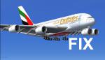
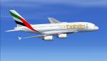
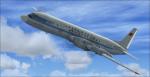
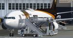
Airbus A380-800 Emirates Expo 2020 A6-EDV Updated
(Category: FSX > Civil Jets)
92.93Mb (25480 downloads)
This is a fixed and updated version of my previous Emirates A380 package. The previous version had a textures error. This version is fixed and VC added. Model by Project Airbus. Textures by Mees Jansen.
Posted Oct 28, 2013 11:13 by Mees Jansen
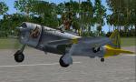
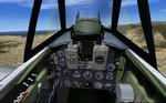
FSX/FS2004 P-47N-2-RE "Chautauqua" and P-47N-5RE"Icky and Me"
(Category: FSX > Vintage)
10.56Mb (2350 downloads)
FSX/FS2004 P-47N-2-RE "Chautauqua" and P-47N-5RE"Icky and Me".
The last of the Thunderbolts to be manufactured in quantity was the P-47N, a specialized long-range version designed for service in the Pacific theatre. The P-47N had a new "wet" wing of slightly larger span and area. It gave excellent service in the Pacific in the final year of the war, particularly in escorting B-29 bombers in raids on the Japanese mainland. They were able to escort bombers all the way from Saipan to Japan and on many other long overwater flights.Tested in FS2004/FSX and FSXacceleration.GMAX mdl by A.F.Scrub.
Posted Oct 28, 2013 05:58 by A.F.Scrub
.jpg-thumb.jpg)
.jpg-thumb.jpg)
FSX Added Views For Junkers Ju-188E Bomber
(Category: FSX > Vintage)
0.35Mb (789 downloads)
FSX cameras for the Junkers Ju-188E bomber from Krzysztof Malinowski and Jay McDanie (Ju188Efsx.zip). There are five added external views plus nine internal views including four gunner positions. A weapon configuration with effects is included. Configuration by Erwin Welker.
Required files:
required file
Posted Oct 28, 2013 05:31 by Erwin Welker
Ilyushin Il-18 Updated Package
(Category: FSX > Props)
50.01Mb (3697 downloads)
This is an update to the Pavel Hvatkin FS2002 Ilyushin IL-18D and Guinart Lopez FS2004 Ilyushin IL18D by replacing incompatible gauges in the Arturr Stechura Il-18 2D panel with gauges by Vladimir Zhyhulskiy. The Hvatkin package includes textures for: Aeroflot, CSA, Interflug, Malev, and Tarom. The Lopez package includes textures for: AeroCaribbean, Aeroflot, CAAC, Cubana, LOT, NPP-MIR, Rossya, and Vietnam presidential transport. Twenty-six textures with thumbnails in all. Includes smoke effect. 2D panel only, no VC panel.
Posted Oct 27, 2013 22:09 by Michael E. Roberts
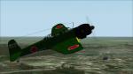
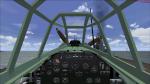
Nakajima B6N2 Tenzan (Jill) Update
(Category: FSX > Vintage)
15.74Mb (1405 downloads)
Updated Nakajima B6N2 Tenzan (Jill) for FSX Acceleration. I used Erwin Welkers/Michael Pooks great VC-update, gun-effects and camera views, put in some panel extra's (bomb scope, radar, japanese minipanel), renewed the air.-file, so now the rear gunner's cockpit opens with the Concorde nose-visor keys and also put in 2 extra textures.
Posted Oct 27, 2013 18:12 by erik hertzberger
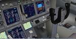
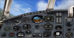
Boeing 767-300 Freighter UPS Cargo winglet with VC
(Category: FSX > Civil Jets)
61.34Mb (6731 downloads)
FSX Boeing 767-300 UPS - United Parcel Service - Cargo with VC for FSX
FSX freighter/cargo model by Project Opensky
with advanced 737-800 VC added. Includes utility for ground services, cargo,
stairs, etc (find it under - Views - Instrument panel - Posky Utility)
The wonderful creation from Project Opensky will be enjoyed by many more people
who do not know how to install a VC, views, exits, Utilities etc into a FSX
native model. So now this 767-300 has the nearest VC I can find -- the 737-800.
The layout fof the 767 cockpit is not a million miles away from the advanced 737
-800.
The VC is the Alejandro Rojas Lucena/FSND fantastic revised Boeing 737-800 VC
model. This VC model includes Working wipers (right mouse click on switch) with
rain effect. Switches for LCD Screens, EICAS, PFD, MFT. Autobrake switch. Opening
pilots window. Cabin Lights switch. Realistic FMC. Ground Proximity Warning
System (GPWS), More Realistic night VC textures. There are custom Boeing sounds
included for that extra realism.
I have used the great UPS (United Parcels Service) textures by Steve McBee.
Also added 767 sounds for more realism. Also added 767-300 exits cfgs so jetways
can be used (Ctrl J)
Model is not modified in any way. Just the VC added and aircraft.cfg edited to
allow correct VC views.
Posky wonderful native FSX Boeing 767-300 models. See VC docs to get the best out
of the VC and FMC.
Prepared and assembled for FSX by Chris Evans.
Posted Oct 27, 2013 08:02 by Chris Evans
Messerschmitt Gigant pack
(Category: FSX > Vintage)
150.27Mb (4435 downloads)
Kazunori Ito's great Messerschmitt Gigant pack, now flyable in FSX Acceleration. All credits for these great designs are for him!! Messerschmitt Me-323E Gigant, Messerschmitt Me-321 Gigant Glider and Heinkel He-111Z Zwilling as towplane for the Gigant Glider. If you follow Thomas Murr's instructions (included) for the towplane, you're should be able to make curves, retract the gear and the flaps. There's something of a VC with working gauges (included), but don't expect too much. I hope you have as much fun flying them as I had updating them! Enjoy!
Posted Oct 27, 2013 06:47 by erik hertzberger
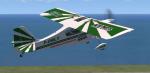
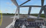
FSX/FS2004 Long Island Classic O'Rielly Textures
(Category: FSX > Props)
1.05Mb (281 downloads)
Textures for the Long island Classic decathlon in fictional O'Rielly Auto parts livery. Enjoy and Happy Flying! Works in FSX and 2004.
Posted Oct 27, 2013 06:46 by Lloyd Horton

PMDG Boeing 777F Qantas Freight (Fictional) Textures
(Category: FSX > Payware)
21.57Mb (3859 downloads)
Qantas Freight 777F (Fictional) repaint for the PMDG Boeing 777F. Textures only.
Posted Oct 27, 2013 06:42 by Darryl Prime
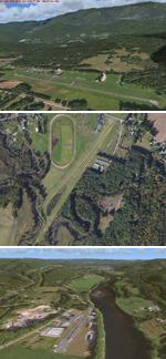
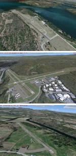
New Hampshire & Vermont 21 Airports Package
(Category: FSX > Scenery)
6.14Mb (2273 downloads)
This package contains 21 airports in New Hampshire and Vermont. These airports are intended to be used with FSX and the free addon - TileProxy. TileProxy provides real-time photorealistic satellite imagery in place of the stock auto generated FSX scenery or any other scenery package. The package includes sixteen (16) stock FSX airports which have been modified (re-located runways, buildings, taxiways, etc.) to more accurately re-position them with the real-world scenery. In addition, there are two (2) unlisted airports which are not available in FSX. These airports are existing real private airports. There are also two (2) "abandoned" airports included (i.e. airports that no longer exist). These airports were active in the 1920s-1970s. There is also one (1) "phantom" airport included (i.e. airport that does not exist in the real world or FSX).
Posted Oct 26, 2013 10:14 by John Greenwood