


All Files > Page 1941
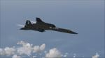
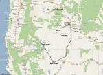
SR-71 Record Speed Run 1
(Category: FSX > Missions)
0.62Mb (2527 downloads)
Welcome to this interesting but very tricky mission. Be sure that you have the instructions printed out and next to you otherwise you will have a lot of difficulties. Remember although this mission seems long, things happen very fast, seconds do play a major role in this mission. Due to the nature of the freeware Alphasim SR71, I don’t know if the mission can be flown with the payware Alphasim SR71, but it should be worth a shot.
Required files:
required file
Posted Jul 8, 2011 08:49 by Robbie Albers

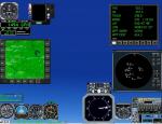
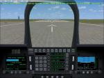
Analog Mini Panel Version 2.1
(Category: FSX > Panels)
7.81Mb (1255 downloads)
FSX Version 2.1 the Analog Mini Panel has been updated with several bug fixes and minor enhancements A major update to Karol Chlebowski spectacular Pave Tack system has been added with documentation to this version. You do not need to download my previous version, everything you need is in this update.
Posted Jul 7, 2011 16:38 by Bill McClellan
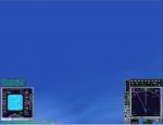
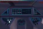
Glass Cockpit Mini Panel Version 2.1
(Category: FSX > Panels)
5.53Mb (1437 downloads)
FSX Version 2.1 Glass Cockpit Mini Panel has been updated with bug fixes and some minor enhancements. A major update of Pave Tack add-on gauge with documentation by Karol Chlebowski has been added to this version that is spectacular. This is an entirely new panel so you do not need to download my previous version.
Posted Jul 7, 2011 16:36 by Bill McClellan
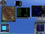
OB-1 Wilder ID Low Altitude Flight Plan
(Category: FS Navigation > Flight Simulator Navigation)
0.92Mb (166 downloads)
FSX Flight Plan for OB-1 Wilder Idaho IFR high speed low altitude military training route. This is the first in a series of flight plans I will be uploading in the near future. These are great routes for B-52, F-111, B-1B, B-2 A6, A4, Vulcan and any fighter or bomber enthusiasts. Of course you can fly the route with any aircraft of your choice. Included in this package are two spectacular gauges by Karol Chlebowski for TFR flying and Pave Tack which includes many advanced features for bombing, navigation and reconnaissance. These two gauges will greatly enhance your ability to fly these challenging routes and are a great companion of the flight plans. Another option to download Version 2.1 of my mini panel which has all this functionality and more.
Posted Jul 7, 2011 16:32 by Bill McClellan
Virtuavia F-22 Comms Radio Fix
(Category: FSX > Military)
0.50Mb (1757 downloads)
Repaired the comms radios so that it didn't have 4 nav radios. Paste folder into F-22 panel folder. Edited by Foxtrot Flyers.
Required files:
required file
Posted Jul 7, 2011 15:54 by John Hauck
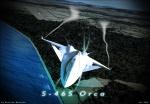
FSX S-46A/S Orca Package
(Category: FSX > Military)
22.15Mb (11702 downloads)
FSX S-46A/S Orca.
Tested with FSX Acceleration.
Model by Ricardo Batalha, texture enhancement and aditional military textures by Mike Durao.
Release video:
http://www.youtube.com/watch?v=bYYVAHiHOGI
Posted Jul 7, 2011 13:22 by Ricardo Batalha
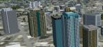
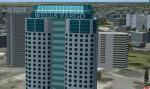
City of Birmingham AL 1.0
(Category: FSX > Scenery)
3.64Mb (1203 downloads)
TalonSim is very excited to bring to you City of Birmingham 1.0. Finally Birmingham, Alabama has character as many features about this historic city have been detailed into Microsoft Flight simulator. This scenery package depicts key architectural structures of The Magic City skyline.
Posted Jul 7, 2011 13:16 by Dexter Pierre Gray and TalonSim
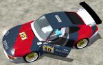
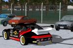
Porsche 911 GT2
(Category: FS2004 > Misc)
4.37Mb (4068 downloads)
Porsche 911 GT2 model, made by Jessy Corrales. Photographical 2-d panel, original Porsche racingsound, great handling and 2 sets of repainted textures by Erwin Welker
Posted Jul 7, 2011 09:13 by Erwin Welker

FSX Boeing 737-800 Batavia Air Textures
(Category: FSX > Civil Jets)
3.62Mb (1017 downloads)
FSX Boeing 737-800 Batavia Air textures for the default B737-800
Posted Jul 7, 2011 07:47 by Muhammad Bukhary

FSX/FS2004 B1900C ERA Alaska Textures
(Category: FSX > Props)
1.18Mb (2323 downloads)
Repaint for the Premier Aircraft Design B1900C in the new livery of ERA Alaska. Suitable for FS9 and FSX.
Era Alaska was recently featured on Discovery Channel's 2011 series, "Flying Wild Alaska".
Requires prior installation of base files b1900c_2_9.zip or b1900c_2_x.zip
Installation instructions included in the zip.
By Jean-Pierre Brisard and Bob May-Premier Aircraft Design
Required files:
required file
Posted Jul 7, 2011 06:24 by Bob May (PAD)