


All Files > Page 1943
-1.jpg-thumb.jpg)
-1.jpg-thumb.jpg)
Boeing 737-800 Air Asia Indonesia Textures
(Category: FSX > Civil Jets)
7.92Mb (4307 downloads)
Air Asia Indonesia textures only for the default Boeing 737-800
Posted Jul 6, 2011 02:37 by ikhsan ramadhan ritonga
-1.jpg-thumb.jpg)
-1.jpg-thumb.jpg)
Boeing 737-800 Citilink Textures
(Category: FSX > Civil Jets)
6.47Mb (1405 downloads)
Citilink Indonesia textures only for the default Boeing 737-800
Posted Jul 6, 2011 02:23 by ikhsan ramadhan ritonga
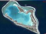
Wake Island Photo Scenery
(Category: FSX > Scenery)
13.91Mb (5015 downloads)
This is Wake Island photoscenery, photo real water, and updated airport. This is a great spot for medium haul cargo runs and makes a challenging flight. The runway can just allow a 747-8 to take off at 100% N1 or land. Now with 100% more fun.
Posted Jul 5, 2011 10:31 by Scenery Dude

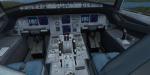
Airbus A319-115 Tibet Airlines B-6436
(Category: FSX > Civil Jets)
13.13Mb (2986 downloads)
Project Airbus Airbus A319-115 Tibet Airlines B-6436 Complete Package for FSX. Featuring Project Airbus's wonderful aircraft of A319, Tibet Airlines Texture by He Lingyuan,China. Tibet Airlines is a new airlines in China and had planned to start operation in July,2011. This package uses Panel, Sound & Virtual Cockpit of the default A321. An Operation Manual written by Project Airbus Members is also included.
Posted Jul 5, 2011 08:43 by He Lingyuan
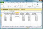
Excell FSX Flightplan Creator
(Category: FSX > Utilities)
4.53Mb (6826 downloads)
FSX Flightplan Creator using Excell V.2
Had to correct formulas.
Here's a complete list of all airports
in the FSX airports file with an
Excell sheet to calculate distances
between airports and a sheet to
create flightplans for an airport
by Gary McDonald
Posted Jul 5, 2011 08:40 by uploader
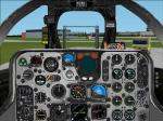
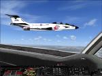
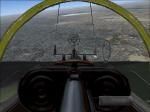
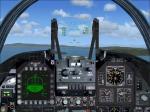
FSX F-101 Voodoo Photorealistic Panel
(Category: FSX > Panels)
1.39Mb (1338 downloads)
FSX photorealistic panel for the fighter F-101 Voodoo with a realistic configuration. Additional cameras allows wingman views, seen from the cockpit plus external views. Configuration from Erwin Welker
Posted Jul 5, 2011 04:58 by Erwin Welker

FS2004/2002 F-101 Voodoo Photorealistic Panel
(Category: FS2004 > Panels)
1.53Mb (1069 downloads)
FS2004/2002 photorealistic panel for the fighter F-101 Voodoo. Panel provides views to 5 directions. Wingmen views, seen from the cockpit, can been inserted at the numpad just hitting some keys for Left_up and Right_up. Two sets of configuration are included. Panel by Erwin Welker
Posted Jul 5, 2011 04:54 by Erwin Welker
FSX Panel Options for Dornier Do17 Nightfighter
(Category: FSX > Panels)
0.62Mb (381 downloads)
FSX panel options for the Dornier Do17 WW2 bomber from "Thicko" and A.F. Scrub (requires: Dornier-do17z.zip). Features: Virtual wingman, views of the bombardier and tailgunner plus external views, smokesystem with guns and bombs. Panel modifications, camera- and smokesystem config from Erwin Welker
Required files:
required file
Posted Jul 5, 2011 04:48 by Erwin Welker
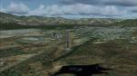
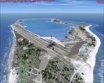
San Juan de los Morros Airport (SVJM) - Venezuela Photo Scenery
(Category: FSX > Scenery)
35.47Mb (1156 downloads)
Small regional airport located in San Juan de los Morros city, the door of entry to the Central Llanos of Venezuela.
With photo-terrain scenery from satellite imagery in Google Earth.
Not compatible with versions prior to FSX.
This scenery includes terminal building and hangars with realistic textures from images obtained from Internet and photos taken by the author on the site. Also includes a friendly Auto-Install.
Posted Jul 4, 2011 21:43 by David Maldonado
FSX/FS2004 Panel for Rockwell Messerschmitt X-31
(Category: FSX > Panels)
2.72Mb (1144 downloads)
FSX/FS2004 Panel for the experimental aircraft with vector controlled thrust Rockwell Messerschmidt X-31 from Italo D'Attomo and Giovanni Quai (requires RockwellX31x.zip for FSX or RockwellX31.zip for FS2004). The style of the panel and the configuration is very close to the real one. The improved VC is matching the 2D-panel. Configuration by Erwin Welker
Required files:
required file
Posted Jul 4, 2011 10:50 by Erwin Welker