


All Files > Page 1358
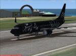
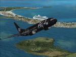
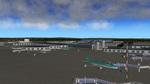
Boeing 737-800 Kings Air Textures
(Category: FSX > Civil Jets)
9.11Mb (512 downloads)
This is a repaint of the FSX default Boeing 737-800. Repaint by M.Folkerts
Posted Dec 7, 2013 15:56 by M.folkerts
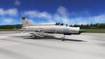
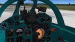
X-Plane 10 MiG-21M v1.0
(Category: X Plane > Military)
49.40Mb (3521 downloads)
X-Plane 10 MiG-21M v1.0. Thanks to Norman (SuperFighter2) for permission to upload this update of his MiG-21 M. Everything contained in this package has been originally created by Norman (every 3D instrument, object, .acf file, etc.). This package includes an updated 3D cockpit. Every 3D instruments in the cockpit has been created by Norman. Updated radar (from Norman's MiG-21PFM). Now shows traffic at correct angles. You can also lock targets. Night lighting in the cockpit. Optimised objects with single sided surfaces. Remapped and retextured external model. New canopy (can be opened pressing shift + F1). Three liveries included: Russia, Croatia, Romania. Also includes a paint kit. By Francesco d'Arpa.
Posted Dec 7, 2013 06:43 by uploader
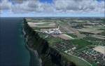
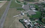
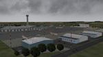
LFOH - Le Havre Octeville - France
(Category: FSX > Scenery)
6.43Mb (3476 downloads)
LFOH - Le Havre Octeville - France - tested with FSX /SP2 and with the NEXTMap ProMesh France 4.75m (FS Dreamscapes).
Le Havre Octeville aiport is in Normandy - region of north-western France
It is situated on the right bank of the estuary of the river Seine on the English Channel. Bruno VALLY
Posted Dec 7, 2013 06:22 by uploader
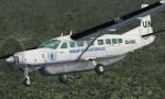
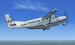
FSX C208B Caravan UN-WFP Textures
(Category: FSX > Props)
2.32Mb (1045 downloads)
Repaint of the default C208B Caravan. Textures for the UN World Food Programme Humanitarian Air Services. Painted by R.E. Wyman.
Posted Dec 6, 2013 23:40 by R.E. Wyman
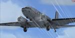
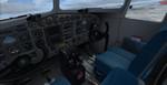
Douglas C-117D, Super DC-3 Package V2
(Category: FSX > Vintage)
22.58Mb (6535 downloads)
FSX Douglas C-117D, Super DC-3 V.2
This revised model features a
modern VC, a realistic slow radial
engine start, a fuel and payload
manager, built-in failure conditions,
improved engine textures and new
engine-focused cameraviews. Sound is
aliased to the default DC-3. Three
C-117D Expansion Packs will be
available separately from Sim-Outhouse:
a custom sound set by Ted "Tufun"
Wolfgang, and a paintkit and two
alternate VC texture sets by Gordon
"Gman" Madison. Historical research by
John Detrick, models by Manfred Jahn,
flight dynamics by Alexander M.
Metzger, gauges, animations, and
failure conditions by Hansjoerg
Naegele. Startup smoke effect by Ted
Wolfgang. DX10 fix included.
Posted Dec 6, 2013 04:06 by uploader
Prepar3D v2 Launcher Utility
(Category: Prepar3d > Utilities)
0.45Mb (1007 downloads)
Prepar3D v2 Launcher Utility. Why you need it?
"Prepar3D v2" starts directly in flight. Even you enable the scenario starup menu on startup there is no option to load your flight from there. Every time, after the default flight gets loaded, you have to go to the menu and load your saved flight from there which is a total waste of time. I created this little utility to solve this little but annoying problem until Prepar3D development team takes care of it. The program will launch "Prepar3D v2" directly with your saved flight that you choose as you will expect.
This method is also a faster way to start the simulator as you don't need to wait anything to be loaded except your saved fight.
Posted Dec 6, 2013 03:06 by Ahmet Mehmetbeyoglu
EGGW London Luton Airport, UK
(Category: X Plane > Scenery)
1.16Mb (1268 downloads)
X-Plane 10 Scenery EGGW London Luton, UK, v1.0. London Luton Airport is an international airport located 1.5 miles east of Luton town center in the Borough of Luton in Bedfordshire, England. Requires Openscenery and special thanks to Walter Blinney for the fuel tank objects. By Rene Bruun (Renair).
Posted Dec 6, 2013 02:56 by uploader
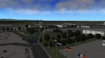
EIDW - Dublin Extreme 2.2, Dublin, Ireland
(Category: X Plane > Scenery)
42.28Mb (1299 downloads)
X-Plane 10 Scenery EIDW - Dublin Extreme 2.2, Dublin, Ireland. One of the most comprehensive sceneries made with OverlayEditor along with OpenScenery 2.0 and RUScenery for XP10. This scenery has over 2500 individually placed objects and not only includes the airport but: Dun Laoghaire Harbour, Dublin Port,Howth Harbour, Malahide Yacht Club, Skerries Dinghys, Skerries Windmill, Dublin Buses, Clongriffin Eco Park, Baldoyle Cyclepath, Baldoyle Village, new fuel depot, Harristown Bus Depot. Special thanks to GOLF1, Walter Blinney, and Mercedes for additional objects. By Rene Bruun (Renair).
Posted Dec 6, 2013 02:15 by uploader
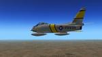
North American Aviation F-86E-6 Sabre 2
(Category: X Plane > Military)
15.92Mb (1617 downloads)
X-Plane 9.70+ North American Aviation F-86E-6 Sabre 2. This plane is based on the Canadair Sabre 6 posted earlier. To convert to a Korean war airplane some changes were made in the model. The wings have a narrower chord. The cockpit is black instead of gray. The engine has been changed to 5200 lb. thrust to represent a J47-GE-13. By Jack Wilkinson.
Posted Dec 6, 2013 02:14 by uploader
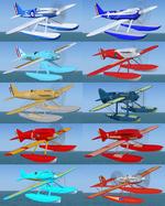
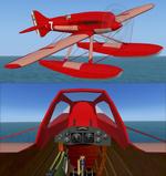
Racing floatplanes from the Virtual Schneider Project updated for FSX
(Category: FSX > Vintage)
65.57Mb (1724 downloads)
10 Racing floatplanes which should have or actually took part in the Schneider Trophy back in 1929. Originally made for FS2004 as part of a freeware project called Virtual Schneider Project by Transglobal. Since the project, makers and models seem to have disappeared from the internet, I decided to not let their work be lost and forgotten. I updated them to make them usable in FSX. They all have a reasonable virtual cockpit. Installation is a simple copy-paste operation. These racers are different beasts to fly: Some need speeds of more than 100 knots to rotate. Most are unstable below 150 knots and require high speed and effective use of the trim to stabilize. Top speeds are surprising for floatplanes and high-g turns, a couple of feet above the water, are what they were made for. All credits go to the original makers of the Virtual Schneider Project. Have fun!
Posted Dec 5, 2013 05:03 by Raoul de Miranda