


All Files > Page 1334
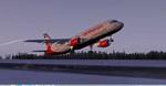
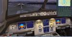
Airbus A320-200 Air Berlin - Etihad Package
(Category: FSX > Civil Jets)
54.57Mb (6832 downloads)
Airbus A320-200 Air Berlin - Etihad for FSX. Includes enhanced default A321 VC with better gauges and popup FMC, GPWS callouts. Custom CFM sounds. Also added jetway configs (Ctrl J) to enable jetways at parking. In January 2014 Etihad Airways and Airberlin announced the expansion of their partnership with the unveiling of a joint-livery Airbus A320. . Model by Project Airbus. Textures by Mathieu Vos. Assembled for FSX by Chris Evans
Posted Jan 16, 2014 08:22 by Chris Evans
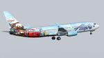
TDS Boeing 737-800 Alaska Airlines "Adventure of Disneyland" Textures
(Category: FS2004 > Civil Jets)
12.09Mb (1062 downloads)
TDS Boeing 737-800 Alaska Airlines "Adventure of Disneyland" Textures. Requires the TDS Boeing 737-800 basepack. Textures by Joe Shimmel.
Required files:
required file
Posted Jan 16, 2014 07:00 by Chris E
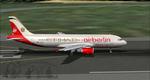
Airbus A320-200 Air Berlin-Etihad
(Category: FS2004 > Civil Jets)
11.54Mb (1947 downloads)
Airbus A320-200 Air Berlin-Etihad BER ETH livery. Model by Project Airbus. Livery by Mathieu Vos.
Posted Jan 16, 2014 06:57 by Chris E
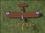
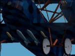
World War I Bombs
(Category: CFS2 > Misc)
0.59Mb (386 downloads)
CFS2 Weapons Pack- World War I Bombs.
By John P Fortin aka Polar_lion
Here are 21 new bombs for use in your World War I installs. These are as accurate as I could make them in both scale and appearance.
***WWI bombs list:
---German---
PuW 50kg bomb and carrier/pylon
PuW 100kg bomb and carrier/pylon
PuW 500kg bomb - For the Large German Bombers
10kg Carbonit bomb - Early aircraft bomb till 1916, Zeppelin Bomb
50kg Carbonit bomb - Zeppelin Bomb
100kg Carbonit bomb - Zeppelin Bomb
300kg Carbonit bomb - Zeppelin Bomb
---French---
75mm Obus shell bomb with long striker and carrier/pylon - Early aircraft bomb till mid 1917
90mm Obus shell bomb and carrier/pylon - Early aircraft bomb till mid 1917
90mm Gros-Andreau bomb with multiple carriers - Used by the AEF, known as the MKIII
90mm Gros-Andreau bomb Vertical Drop - For the SPAD XIII
115mm Michelin Bomb and carrier/pylon
120mm Gros-Andreau bomb - Used mainly in 1917 due to shortage of 155mm shells
120mm Gros-Andreau bomb Vertical Drop - For the SPAD XIII
155mm Gros-Andreau bomb and carrier/pylon - Used by the AEF as well
---British---
50 lb Cooper bomb and carrier/pylon - For the Tondern Raid, Used by the RN
65 lb Royal Lab bomb and carrier/pylon - Smaller version of the RL 112 lb, used around 1917 to early 1918 mostly experimental.
112 lb Royal Lab bomb and carrier/pylon - A re-sized version of Aerocrates Rl 112 lb. True to scale
230 lb RFC bomb and carrier/pylon - Anti Sub and heavy structure
520 lb Royal Lab Bomb and carrier/pylon - Anti Sub bomb used by the Felixtowe F2
1650lb SN bomb - Largest allied bomb of WWI, used by the HP 0/400.
I have tried to be as historicly accurate as possible but 100 year old information is hard to come by. Even with the vast amounts avalable online it was a challange. Still I hope you enjoy.
Posted Jan 15, 2014 18:26 by John P Fortin
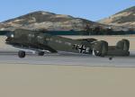
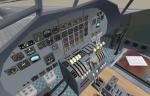
FSX/ FSX Acceleration Junkers JU-90 Military
(Category: FSX > Vintage)
15.07Mb (2529 downloads)
FSX/FSX Acceleration Junkers JU-90.
Deutsche LuftHansa put a request for a long-distance commercial aircraft as early as 1933. The Junkers Ju 90 was a four-engine all-metal, low-wing aircraft fitted with twin end-plate vertical stabilizers. There were four or five divided fuselage sections, the latter holding the maximum of 40 passengers. There were toilets, a cloakroom and a mail store aft, and a baggage hold forward of the passenger space. The fuselage was generous by the standards of the time. In April 1939, the RLM asked Junkers for a further development of the Ju 90 for military transport purposes. Original model by Hauke Keitel. Upgrade to FSX/FSX Acceleration by A.F.Scrub.
Posted Jan 15, 2014 10:21 by A.F.Scrub
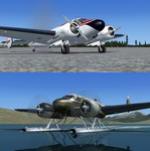
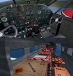
Beechcraft D18S Wheels, Cargo and Floats Package
(Category: FSX > Props)
127.41Mb (8985 downloads)
Beechcraft D18 S wheeled / amphibian / amphibian passenger / float / cargo versions, in standard and BFU Bush Flying Club textures. Model by Milton Shupe, Scott Thomas and Andre Folkers. This file was uploaded by anon but had issues. Fixed by request by Danny Garnier.
Posted Jan 15, 2014 03:31 by palyarmerc
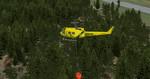
Bell 205 CONAF Chile
(Category: FSX > Helicopters)
7.13Mb (2506 downloads)
Bell 205 CONAF (Corporacion Nacional Forestal) (Chile national Forest Service). Original bambi bucket model by Jordan Moore and textures by juan30005
Posted Jan 14, 2014 23:12 by juan30005
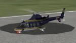
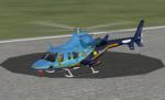
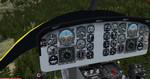
Views for the Bell 430
(Category: FSX > Helicopters)
0.12Mb (1390 downloads)
Additional views ( defined by camera definitions in the aircraft.cfg file ) for
the beautiful Gmax Bell 430 model by Alan Devins and Rory Kelly.
Additional work by Keith Devins, Brian McIntyre, George Arana,
Lynn Rogers, and Zack Schwendenman. Updated first by Ben Batey and second
by Michael E. Roberts. Required package : "Bell 430 Updated package".
1 set of definitions for both models : Wheels and Skids.
9 cameras pointing at the aircraft and 3 additional cameras inside.
See Read me.txt file for very easy installation procedures.
Also included is a text file that contains the new camera definitions.
Finally, two pdf documents for more info about my packages.
Enjoy !
Required files:
required file
Posted Jan 14, 2014 19:13 by Marc Renaud
.jpg-thumb.jpg)
.jpg-thumb.jpg)
FSX Henschel HS P75 Fighter Concept With Canards
(Category: FSX > Vintage)
8.94Mb (2240 downloads)
FSX Henschel HS P75 concept fighter with canards. That german design from the year 1941 was to be a possible successor to the Messerschmitt Bf 110 heavy fighter and used at the beginning the same engines as the He-177 bomber. Later the unreliable engines war replaced with a 3000hp Daimler Benz DB610. The aircraft can exceed 420 mph in level flight using it's counter rotating pusher props. The FS2002-model from Steve Robinson comes with with sound and 3 liveries, including one air brushed air racer. I converted the model to FSX and replaced his modern gauges in the VC with FSX-compatibe, mostly typical german WWII-gauges and created three 2D-panels matching the three paint schemes. Weapon effects are included. Panel bitmaps and configuration by Erwin Welker.
Posted Jan 14, 2014 05:17 by Erwin Welker
FS Scenery Manager V 1.5
(Category: FSX > Utilities)
0.15Mb (1491 downloads)
FS Scenery Manager is a little tool to manage easily sceneries of FSX.
The main particularity is the possibility to classify scenery into folder, for a simplified management of several sceneries in one click.
The scenery.cfg file is found automatically using the registry base.
Posted Jan 14, 2014 05:16 by simviator