


All Files > Page 1454
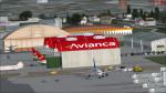
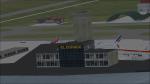
El Dorado International Airport, Columbia final.V1
(Category: FSX > Scenery)
16.94Mb (2870 downloads)
El Dorado International Airport in Bogota, Columbia. New international terminal and cargo terminal, engine test area. Update for El Dorado International Airport, Columbia (Beta)
Posted Jun 23, 2013 13:09 by Gabriel Marin
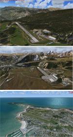
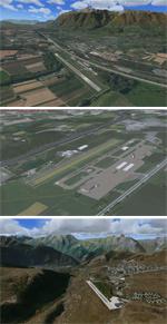
French Alps Airports - FSX/Tile Proxy
(Category: FSX > Scenery)
5.81Mb (7196 downloads)
This package contains 15 airports, most are in the French Alps near Grenoble/Courchevel. These airports are intended to be used with FSX and the free addon - TileProxy. TileProxy provides real-time photorealistic satellite imagery in place of the stock auto generated FSX scenery or any other scenery package.
The package includes six (6) stock FSX airports which have been modified (re-located runways, buildings, taxiways, etc.) to more accurately re-position them with the real-world scenery.
In addition, there are seven (7) unlisted airports which are not available in FSX. These airports are existing real private airports in the French Alps near Courcheval and Grenoble.
There are also two (2) "phantom" airports included (i.e. airports that do not exist in the real world or FSX).
Posted Jun 23, 2013 02:39 by John Greenwood
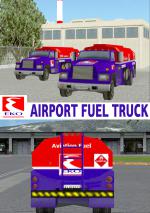
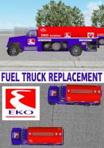
Airport Fuel Truck EKO Replacement Textures
(Category: FSX > Misc)
4.43Mb (2350 downloads)
EKO Airport moving Fuel Truck Replacement Pack.I dont know about you but I was bored of that litle truck moving around with no company logo on it in my airports, so i decided to change it to something more realistic. This will change your standard Air Fuel 100LL truck that you see in your airports supplying fuel, with an EKO Fuel truck. This is a low polygon FSX default model that I added new textures. I have 2 sets of textures in normal 1024 or low 512 resolution DDS1 for you to choose from. Simple copy and paste installation with instructions. Also small tutorial on how to add fuel truck services to any of your favorite small airports that don't have one. You could repaint the texts also to any other fuel co. of your choice. By Hellenic Aircraft/Yiannis Katehis Tsetsas.
Posted Jun 22, 2013 20:26 by YIANNIS KATEHIS TSETSAS
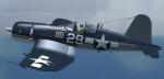
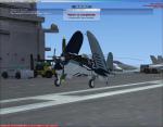
FS2004/FSX FG-1D Corsair VF-17 Textures
(Category: FS2004 > Vintage)
1.84Mb (1828 downloads)
FS2004/FSX FG-1D Goodyear, VF-17 "French Army Chance Vought F4U-7 Corsair" textures for the Alpha Bleu F4U Corsair. Note: Original model is the FG-1D, with a 3-blade propeller and other differences, not this one. Requires original model of the FS2004 ALPHA BLEU CIEL French Chance Vought F4U-7 Corsair and update (or the FSX version):
-TESTED AND WORKS IN FSX-
Posted Jun 22, 2013 20:03 by Enrique Medal
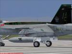
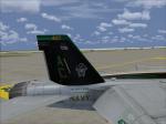
VRS Superbug VFA-105 CAG 2013 Textures
(Category: FSX > Payware)
1.69Mb (205 downloads)
Textures of the current Gunsliners CAG for 2013. Requires the payware VRS Superbug.
Posted Jun 22, 2013 15:00 by Christopher Hammons
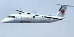
Jazz Complete Fleet
(Category: FSX > Civil Jets)
79.16Mb (10085 downloads)
Air Canada Jazz complete fleet for FSX only!
CRJ-200, CRJ-700, Q400, Dash-8-300, Dash-8-100, all in the Jazz old and new liveries! enjoy! V1.00
Posted Jun 22, 2013 14:19 by Etienne Durocher
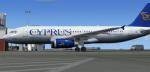
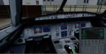
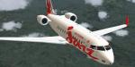
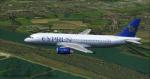
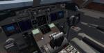
Airbus A320-200 Cyprus Airways Package
(Category: FSX > Civil Jets)
51.06Mb (4996 downloads)
Airbus A320-200 Cyprus Airways for FSX. Includes enhanced default A321 VC with
better gauges and popup FMC, GPWS callouts. Custom Airbus sounds. Also added
jetway configs (Ctrl J). Cyprus Airways operates scheduled services to 22
destinations in Europe and the Middle East from its hub Larnaca. As of April
2013, Cyprus Airways operates 7 Airbus A320's and 2 Airbus A319's. Model by
Project Airbus. Textures by Mathieu Vos. Assembled for FSX by Chris Evans
Posted Jun 22, 2013 06:23 by Chris Evans
Airbus A320-200 Cyprus Airways
(Category: FS2004 > Civil Jets)
12.28Mb (1468 downloads)
FS2004 Cyprus Airways Airbus A320-200
Discription: This is an Airbus A320-200 of Cyprus Airways. Registration: 5B-DCH, Repaint by: Mathieu Vos (APSS), Model by: Project Airbus.
Posted Jun 22, 2013 05:44 by Chris E
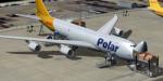
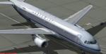
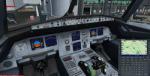
Atlas Air Polar/DHL Boeing 747-8F Package
(Category: FSX > Civil Jets)
69.11Mb (5276 downloads)
Atlas Air Polar/DHL Boeing 747-8F, N853GT
Assembled and upgraded for FSX with the developed B747 VC (virtual 3d cockpit)
from Alejandro Rojas Lucenda. This is the Project Opensky FSX native Boeing
747-8F GenX cargo model, and includes ground cargo servicing, stairs (FSX - Go
to Views - Instrument Panel -Posky Utility), opening nose section and more.
Included CF engine sounds from BrandonG, with realistic jet whine to make your
flight sound great.
Upgraded using the vastly improved Boeing 747 VC from Alejandro Rojas
Lucena/FSND (See panel docs for details). VC includes FMC, EICAS, MFD with
control panel, GPWS, working wipers, cabin lights, fire suppression, avionics
switch, fuel crossfeed, landing lights switches, taxi light switch, engine
generators, APU generator, battery switch, starter switches, de-ice switch,
general lights switches.
Thank you to Skyspirit for their outstanding donations to the worldwide
community of flight simulation. Beautiful Atlas/DHL textures by Mathieu Vos.
Also includes the Boeing 747 VC textures upgrade. This give a much clearer 747
interior virtual cockpit look.
Assembled and edited for FSX by Chris Evans.
Zip preview for larger pictures.
See panel docs and images for VC details and controls!
Posted Jun 22, 2013 05:00 by Chris Evans
Airbus A320-200 Aeroflot Retrojet for FSX
(Category: FSX > Civil Jets)
52.61Mb (2780 downloads)
Aeroflot Airbus A320-200 Retrojet for FSX. Includes enhanced default A321 VC with better gauges and popup FMC, GPWS callouts. Custom Airbus sounds. Also added jetway configs (Ctrl J). Aeroflot Russian Airlines (Moscow) introduced an Airbus A320 retrojet in 2013 painted in the 1956 Tupolev Tu-104 Model by Project Airbus. Textures by Mathieu Vos . Assembled for FSX by Chris Evans
Posted Jun 22, 2013 04:08 by Chris Evans