


All Files > Page 1656
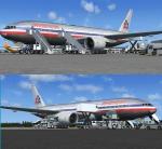
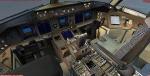
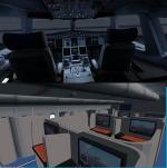
Boeing 777-200ER - American Airlines Package
(Category: FSX > Civil Jets)
37.64Mb (17196 downloads)
Project Opensky -- Boeing 777-200ER - American Airlines Aluminium Textures Package. Boeing 777-200 Rolls Royce Trent VC model.
The textures are saved in 32bit format for quality graphics.
Includes Posky VC with FSX gauges added by Danny Garnier.
Wonderful Boeing 777-200ER Trent VC model by Project Opensky.
Includes ground services (Views - Instrument Panel - Posky Utilities).
Textures by Posky Team Member.
Happy Flying!
Updated for FSX by Chris Evans
Posted Jul 17, 2012 08:14 by chris evans
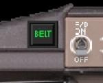
Seatbelt Sign Gauge
(Category: FS Gauges > FS Gauges)
0.22Mb (1066 downloads)
Just put this on your aircraft panel. Tested on FS2004 (FS9). Might also work on FSX or FS2002.
Posted Jul 16, 2012 13:43 by Alexander Speer


Mermaid Lake of Nepal
(Category: FSX > Missions)
19.55Mb (2061 downloads)
E-Short Story and Adventure Flight.." Max Rex woke up as the far away thunder and wind made the flaps of his bedroom
window slam against the wall. He got up and walked to the window and felt the
humid wind from the coming storm. He looked at his watch noting it was very early,
only 4:55 am. He saw huge cumulus clouds churning as the stormwind pushed them
toward the small city of Bhinga in northern India. Max had come to visit his old friend
Dr. Ernest Wingall Bloom, archaeologist and man of great knowledge."--Read the short story and Join Bella, her father, Dr. Wingal and Max in an adventure into Nepal. The Mermaid lake is said to be cursed but the expedition must go on!!. Experienced bush pilots will find all the clues to find the lake and solve the mystery!!!! Must be able to read maps and navigate by the seat of your pants!!! no easy GPS stuff around the Himalayas...join the expedition and either succed or go bust!!!
Posted Jul 16, 2012 11:43 by Gera Godoy Canova
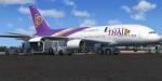
Airbus A380-841 Thai
(Category: FSX > Civil Jets)
62.36Mb (18942 downloads)
Airbus A380-841 Thai for FSX.
Package includes the great added VC. Credits go to the great talent
of Project Airbus team for the wonderful model and Carlos Salas for
great Thai repaint. Includes VC and interior seating. Includes
custom heavy sounds by Brandon G. Assembled for FSX by Chris Evans
Posted Jul 16, 2012 09:59 by chris evans
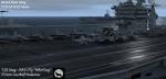
AI Carriers 2 - Carrier Group
(Category: FSX > Scenery)
0.00Mb (4468 downloads)
Just somthing i came up with within Aicarriers2. Instead of one carrier you can now have 5 carriers. 2 have crowded decks. There are also cruisers and destroyers. Requires AI Carriers 2
Posted Jul 16, 2012 04:21 by Dominic Monaco - Fsx Gamespy EASST9
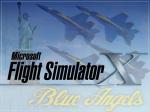
Blue Angels FSX Splashscreen
(Category: Videos/Splashscreens > Splashscreens)
0.79Mb (338 downloads)
This is a U.S. Navy Blue Angels splashscreen for FSX. The splashscreen is what appears before the game itself. I have included a backup file and instructions.
Posted Jul 15, 2012 23:19 by nickthatch12
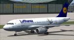
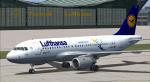
Airbus A319 Lufthansa Package
(Category: FSX > Civil Jets)
73.98Mb (14737 downloads)
Project Airbus A319 Lufthansa D-AILU for FSX.
Includes two different paints of the Lufthansa "LU"
and default VC, upgraded by Jim Fly.
Posted Jul 15, 2012 07:46 by Jim Fly
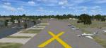
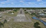
Spruce Creek Fly-in Community, Florida
(Category: FSX > Scenery)
5.31Mb (2163 downloads)
Spruce Creek Fly-in Community (7FL6)
Touted as the worlds most famous residential airpark, this airfield resides within the Daytona Beach International Airport (KDAB) controlled airspace. More information is available at www.7fl6.com. The scenery includes photo landclass changes, rework of the runway, taxiways, aprons and parking; custom scenery objects and placement of library objects. Scenery in this package is based on Virtual Earth (Bing) and Google Earth imagery and photos taken locally. The package includes airport arrival-departure procedures published by the Fly-in and scenery associated with the VFR "Tank Departure". By: Art Poole
Posted Jul 15, 2012 07:44 by uploader
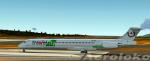
Maddog MD82 Trawel Fly Textures
(Category: FS2004 > Payware)
12.63Mb (369 downloads)
TRAWEL FLY Reg. YR-HBE textures for the payware Maddog MD80
Posted Jul 14, 2012 22:40 by Trino Rojas

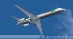
Boeing B737-800 TAM Textures
(Category: FSX > Civil Jets)
3.10Mb (2336 downloads)
New livery of TAM Linhas Aereas, the national carrier of Brazil. Textures for the default FSX B737-800.
Posted Jul 14, 2012 20:53 by good textures