


All Files > Page 1927
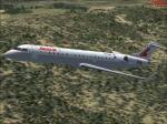
CRJ 700 Lauda Air Textures
(Category: FSX > Civil Jets)
6.02Mb (886 downloads)
Textures only for the default FSX CRJ-700 in Lauda Air
Posted Jul 30, 2011 14:16 by Christoph Stark
Boeing 737-800 Kulula.com Textures
(Category: FSX > Civil Jets)
6.69Mb (997 downloads)
Boeing 737-800 Kulula.com Textures for the default FSX B737-800. This is a popular South African Budget airline which operates all over South Africa.
Posted Jul 30, 2011 04:56 by Michael Adkin
Virginia Airshow Scenery
(Category: FSX > Scenery)
10.62Mb (542 downloads)
Realistic layout for the Virginia Airshow held at the Warren County Airport in Virginia, USA.
Posted Jul 30, 2011 03:42 by Michael Adkin
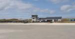
Palermo Punta Raisi Intl Airport, Italy
(Category: FSX > Scenery)
15.10Mb (5575 downloads)
Palermo Punta Raisi, Italy (also known as Falcone-Borsellino Airport) is a big airport situated on Punta Raisi cape. It was built to replace Boccadifalco Airport, because the air traffic was too high for a small airport like that.
It is made for a high density air traffic, with many jetways and many parkings. Many planes, from small turboprop to huge jetliners come from many part of the world.
There are charter flights from Russia and many other countries!
This first version (we will update it soon) Is made to replace the poor, wrong, inaccurate, (and who want to add somethig else is welcome!!!!) default airport.
Aprons setted as the real Airport.
Jetway linked to another building, linked to the main terminal, like in reality Airport full of objects
4 Fueltrucks
Posted Jul 29, 2011 13:22 by Skara Scenery
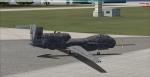
RQ-4 Global Hawk UAV Package
(Category: FSX > Military)
11.25Mb (10832 downloads)
RQ-4 Drone UAV/UACV Remake. Redid cockpit and added 2 textures, added a few sound files. Use the VC for take photographs. The Northrop Grumman (formerly Ryan Aeronautical) RQ-4 Global Hawk (known as Tier II+ during development) is an unmanned aerial vehicle (UAV) used by the United States Air Force and Navy as a surveillance aircraft. Enjoy.
Posted Jul 29, 2011 13:02 by Robert Wahrenbrock
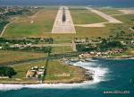
EGPR- Barra Beachport, Scotland
(Category: FSX > Scenery)
11.85Mb (3712 downloads)
Barra Airport in Scotland (also known as Barra Beachport) is the unique airport which operates scheduled passenger flights on a beach. You can see British Airways, Flybe planes,( operated by Loganair) land on the sand. It's one of the most dangerous airport in the world. There is a small terminal, a car park, and 3 runways with red poles to sign where runway starts and finishes. Flights are operated in most of the time in the day, but sometimes you might find a nightime flight.It operates when there's low tide, when the wind blows also just a bit or there's high tide, all flights are cancelled. Usually are operated flights with a DHC 6 Twin Otter, which is one of a very few planes can land on the sand.
Posted Jul 29, 2011 12:22 by Skara Scenery
FSX Linz Ost Airfield (LOLO) Austria
(Category: FSX > Scenery)
0.00Mb (824 downloads)
LOLO Linz is a small Airfield near the Linz harbour... It is used for Gliders and Ultralights...
Posted Jul 29, 2011 07:26 by Alex Grünwald
FSX Ried Kirchheim ( LOLK) V2 Austria
(Category: FSX > Scenery)
0.00Mb (560 downloads)
This file adds two Runway starts and a windsock and windtee to the default Ried Kirchheim scenery in Austria.
Posted Jul 29, 2011 07:13 by Alex Grünwald
FSX Cameras for Savoia Marchetti SM79 from Manuele Villa
(Category: FSX > Vintage)
0.42Mb (489 downloads)
FSX cameras for the italian bomber/torpedo bomber Savoia Marchetti SM79 Sparviero from Manuele Villa (sm79_v01.zip). There are 9 cameras providing internal and external views, f.i. the rear gunner view or animated waist gunners. Configuration by Erwin Welker.
Required files:
required file
Posted Jul 29, 2011 04:11 by Erwin Welker
Map of CFS2 Airfields in Google Earth
(Category: CFS2 > Misc)
0.00Mb (368 downloads)
This KML file contains all of the locations of airfields listed in Combat Flight Simulator 2. The coordinates of each airfield were drawn from the "airbases.dat" file.
Open this file in Google Earth (free from Google), and viola! The location of all airfields are plotted for your use and navigation.
** DISCLAIMER **
This KML file was generated using code I wrote in the Microsoft .NET C# programming language. Any comments, additional features desired or questions about its use should be directed to me at my email address: ghtwo@live.com
Thanks, and I hope you enjoy.
Greg Harrison
Posted Jul 29, 2011 03:26 by Greg Harrison