


All Files > Page 1340
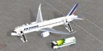
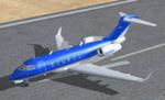
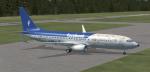
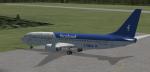
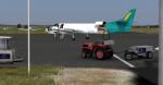
FSX Airbus A320 NEO Air France
(Category: FSX > Civil Jets)
10.40Mb (6140 downloads)
The Airbus A320 NEO (New Engine Option) is the successor of the very popular A320 with a lowest fuel consumption. Prototypes are being constructed and first flight is foreseen by the end of 2014. Here is the Air France version from Camil Valiquette including AGS (Advanced Ground Servicing). 2D panels for wide and standard screen (no VC), GPWS callout, and warning horn callout by Philippe Wallaert. Clock gauge by Pierre Fasseaux. See instructions in the readme.txt file. Credits: Camil Valiquette for the original and excellent aircraft. Nice flights!
Posted Jan 6, 2014 11:22 by Philippe Wallaert
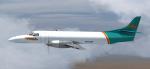
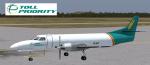
Razbam Metroliner TOLL Priority VH-UZW Textures
(Category: FSX > Payware)
10.88Mb (272 downloads)
Textures for the payware Razbam sim Metroliner TOLL Priority VH-UZW with and without windows. You only have to use the one texture folder for the 2 paints.
Repaint Darryl Prime
Posted Jan 6, 2014 04:40 by Darryl Prime
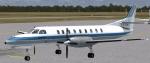
Views for the Bombardier Challenger 300
(Category: FSX > Civil Jets)
0.10Mb (852 downloads)
Additionnal views ( defined by camera definitions in the aircraft.cfg file ) for
the use with the "Bombardier Challenger 300" package by Richard Schwertfeger.
This set of views consists in 9 cameras pointing at the aircraft and 3 virtual cockpit cameras,
which includes the two original views by Richard Schwertfeger. They have been
integrated in the camera definitions set for making it easier to install them.
See Read me.txt file for very easy installation procedures.
See camera definitions.txt for the new camera definitions.
Enjoy !
Required files:
required file
Posted Jan 5, 2014 16:10 by Marc Renaud
Layout package IV
(Category: CFS2 > Utilities)
0.35Mb (394 downloads)
This is a Mission Builder support package containing various layouts for ETO mission writers which allow you to place ready-made structures in any location, or in the location where I have placed them.
It contains ready-made layouts for your missions that allow you to place targets and infrastructure. These include a factory complex, a ball bearing plant, a massive Focke-Wulf assembly plant, a large oil refinery, a small oil refinery near Hawkinge, a large rail yard, a Norwegian command post, and American vehicle depot, the Amiens prison complex, a small munitions factory, a small oil refinery, a wooded radio station, a wooded rail line, and a wooded Radar station.
Also included is a Hawker aircraft plant in southeast England. This is a GSL scenery item that has its own airfield entry for you to utilize.
Rami
Posted Jan 5, 2014 13:02 by Andrew Talbot
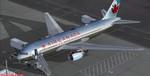
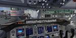
Boeing 767-200 ER Air Canada Bare Metal with VC
(Category: FSX > Civil Jets)
68.99Mb (15176 downloads)
FSX Boeing 767-233ER Air Canada Bare Metal with VC for FSX
FSX 767-200 model by Skyspirit
with advanced 737-800 VC added. Includes utility for ground services, cargo,
stairs, etc (find it under - Views - Instrument panel - Posky Utility)
The wonderful creation from Project Opensky will be enjoyed by many more people
who do not know how to install a VC, views, exits, Utilities etc into a FSX
native model. So now this 767-300 has the nearest VC I can find -- the 737-800.
The layout fof the 767 cockpit is not a million miles away from the advanced
737-800.
The VC is the Alejandro Rojas Lucena/FSND fantastic revised Boeing 737-800 VC
model. This VC model includes Working wipers (right mouse click on switch) with
rain effect. Switches for LCD Screens, EICAS, PFD, MFT. Autobrake switch.
Opening pilots window. Cabin Lights switch. Realistic FMC. Ground Proximity
Warning System (GPWS), More Realistic night VC textures. There are custom
Boeing sounds included for that extra realism.
I have used the great professional Canadian textures by Jorge Santiago.
Also added 767 sounds for more realism. Also added 767-200 exits cfgs so
jetways can be used (Ctrl J)
Model is not modified in any way. Just the VC added and aircraft.cfg edited to
allow correct VC views.
Skyspirit wonderful native FSX Boeing 767-300 model. See VC docs to get the
best out of the VC and FMC.
Prepared and assembled for FSX by Chris Evans.
Posted Jan 5, 2014 11:59 by Chris Evans
Boeing 737-800 'Facebook' Textures
(Category: FSX > Civil Jets)
0.50Mb (567 downloads)
Fictional 'Facebook' textures for the default FSX Boeing 737-800
Posted Jan 5, 2014 11:17 by Holger Tummel
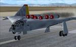
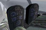
FSX Arado E555-1 updated
(Category: FSX > Vintage)
25.64Mb (1960 downloads)
The construction of this futuristic looking flying wing type jet bomber was started by Arado for the German Luftwaffe in December 1943. However, a year later Arado was ordered to cease all work on this amazing bird, probably due to the worsening war situation. The package features FSX compatible gauges, a new basic VC and smoke effects. Original model by Kazunori Ito, VC and update for FSX by Michael Pook.
Posted Jan 5, 2014 05:22 by Michael Pook
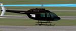
Oklahoma Highway Patrol Textures (fixed)
(Category: FSX > Helicopters)
4.07Mb (304 downloads)
Oklahoma Highway Patrol textures for the default FSX Bell 206B. Enjoy and Happy flying
Posted Jan 4, 2014 22:50 by lloyd hortpm
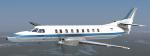
Razbam Metroliner Luxair Textures
(Category: FSX > Payware)
10.35Mb (342 downloads)
Luxair textures for the payware Razbam Metroliner.
Repaint Darryl Prime
Posted Jan 4, 2014 18:00 by Darryl Prime
Razbam Metroliner Toll Priority Textures
(Category: FSX > Payware)
10.39Mb (207 downloads)
Toll Priority textures for the payware Razbam Metroliner.
Repaint Darryl Prime
Posted Jan 4, 2014 17:53 by Darryl Prime