


All Files > Page 1413
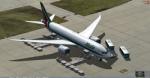
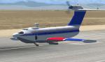
Boeing 787-8 Series Alitalia with VC for FSX
(Category: FSX > Civil Jets)
111.94Mb (6318 downloads)
Boeing 787-8 Series Alitalia with VC for FSX
Model by TDS/ Tenkuu Developers Studio
with advanced 737-800 VC added. Includes utility for ground services, Passenger buses, cargo, stairs, etc (find it under - Views - Instrument panel - Util)
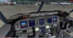
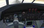
The wonderful new Boeing 787-8 from TDS will be enjoyed by many more people who do not know how to install a VC into a FSX native model. So now the 787-8 has the nearest VC I can find -- the 737-800. The layout fof the 787 cockpit is not a million miles away from the advanced 737-800.
The VC is the Alejandro Rojas Lucena/FSND fantastic revised Boeing 737-800 VC model. This VC model includes Working wipers (right mouse click on switch) with rain effect. Switches for LCD Screens, EICAS, PFD, MFT. Autobrake switch. Opening pilots window. Cabin Lights switch. Realistic FMC. Ground Proximity Warning System (GPWS), More Realistic night VC textures. There are custom Boeing sounds included for that extra realism.
Alitalia textures by Aziz Polash
Model is not modified in any way. Just the VC added and aircraft.cfg edited to allow correct VC views.
TDS wonderful native FSX Boeing 787-8 model. See VC docs to get the best out of the VC and FMC.
Modified and assembled for FSX by Chris Evans.
Posted Aug 30, 2013 15:38 by Chris Evans
FSX Niger Airfield Locator
(Category: FS Navigation > Flight Simulator Navigation)
2.50Mb (80 downloads)
Tested on Windows XP and Windows 7.
This download adds airfield markers and ICAO id's found in FSX, and overlays them on Google Earth.
This file is for Niger.
There is also a seperate file with a list of basic airfield location details.
i.e: EGBB Birmingham Airport. Birmingham. N52* 27.23' W1* 44.88' alt325.
Also the tidying "My places" in Google Earth, file.
Other locator files to follow.
by Carl Vokes
Posted Aug 30, 2013 14:35 by carl vokes
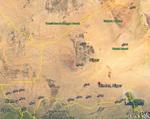
FSX Tanzania Airfield Locator
(Category: FS Navigation > Flight Simulator Navigation)
2.47Mb (127 downloads)
Tested on Windows XP and Windows 7.
This download adds airfield markers and ICAO id's found in FSX, and overlays them on Google Earth.
This file is for Tanzania.
There is also a seperate file with a list of basic airfield location details.
i.e: EGBB Birmingham Airport. Birmingham. N52* 27.23' W1* 44.88' alt325.
Also the tidying "My places" in Google Earth, file.
Other locator files to follow.
by Carl Vokes
Posted Aug 30, 2013 14:34 by carl vokes
FSX update of the Alphasim 2002/2004 A-90 Orlenok Ekranoplan
(Category: FSX > Military)
6.02Mb (1638 downloads)
This is an FSX/ FSX acceleration update of the FS2002/2004 Alphasim A90 Orlenok Ekranoplan, an amphibian Soviet Union aircraft of the 1970s.
Posted Aug 30, 2013 11:23 by Michael Pook
.jpg-thumb.jpg)
.jpg-thumb.jpg)
FSX Pilotable IJN Battleship Yamato
(Category: FSX > Misc)
4.78Mb (2127 downloads)
FSX pilotable Battleship Yamato. This huge japanese warship was together with the Musashi the biggest bettleship ever, armed with three 46cm triple mainguns and finally with over 100 AA-guns. This FS-model is a detailed CFS2 ship made by Usio no Ibuki. It was converted to FSX by Lazarus Starkweather. My AddOn provides a pilotable ship with 2D panel as navigation bridge and four VC-cameras. Sixteen other cameras allows you to explore the ship including the options to set two Aichi Jake floatplane onto the catapults. Included are artillerie-, AA-gun-, target hit fire and general ship-effects. Bitmaps and configuration by Erwin Welker
Posted Aug 30, 2013 05:53 by Erwin Welker


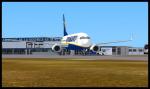
Airbus A320 FLYNIKI Package (Updated)
(Category: FSX > Civil Jets)
58.81Mb (2883 downloads)
UPDATED
Project Airbus A320 FLYNIKI for FSX.
Includes default VC,with upgraded textures by Jim Fly.
You can find this aircraft under 'Project Airbus' in your FSX menu.
Repaint by Jim Fly
Posted Aug 30, 2013 05:41 by Jim Fly
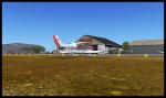
La Rochelle LFBH, France, Scenery Package V3
(Category: FSX > Scenery)
66.70Mb (11655 downloads)
Scenery package for La Rochelle International Airport version3. Situated in Western France, this airport accommodates low cost carriers including EasyJet and Ryanair. Detailed scenery with all the buildings, static planes, etc.
Posted Aug 29, 2013 16:10 by Alexandre REMY - FAF010
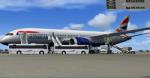
Boeing 787-8 Series British Airways "G-ZBJB" Package
(Category: FSX > Civil Jets)
115.58Mb (5516 downloads)
FSX Boeing 787-8 Series British Airways "G-ZBJB" with VC for FSX
Model by TDS/ Tenkuu Developers Studio
with advanced 737-800 VC added. Includes utility for ground services, fuelling, passenger buses, cargo, stairs, etc (find it under - Views - Instrument panel - Util)
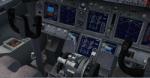
The wonderful new Boeing 787-8 from TDS will be enjoyed by many more people who do not know how to install a VC into a FSX native model. So now the 787-8 has the nearest VC I can find -- the 737-800. The layout fof the 787 cockpit is not a million miles away from the advanced 737-800.
The VC is the Alejandro Rojas Lucena/FSND fantastic revised Boeing 737-800 VC model. This VC model includes Working wipers (right mouse click on switch) with rain effect. Switches for LCD Screens, EICAS, PFD, MFT. Autobrake switch. Opening pilots window. Cabin Lights switch. Realistic FMC. Ground Proximity Warning System (GPWS), More Realistic night VC textures. There are custom Boeing sounds included for that extra realism.
BA textures by Mathieu Vos
Model is not modified in any way. Just the VC added and aircraft.cfg edited to allow correct VC views.
TDS wonderful native FSX Boeing 787-8 model. See VC docs to get the best out of the VC and FMC.
Assembled and prepared for FSX by Chris Evans.
Posted Aug 29, 2013 15:48 by Chris Evans
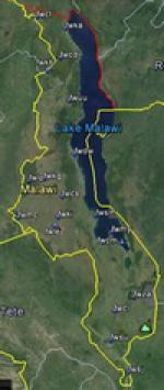
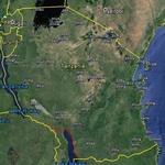
FSX Malawi Airfield Locator
(Category: FS Navigation > Flight Simulator Navigation)
2.42Mb (78 downloads)
Tested on Windows XP and Windows 7.
This download adds airfield markers and ICAO id's found in FSX, and overlays them on Google Earth.
This file is for Malawi.
There is also a seperate file with a list of basic airfield location details.
i.e: EGBB Birmingham Airport. Birmingham. N52* 27.23' W1* 44.88' alt325.
Also the tidying "My places" in Google Earth, file.
Other locator files to follow.
by Carl Vokes
Posted Aug 29, 2013 14:20 by carl vokes
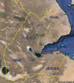
FSX Djibouti Airfield Locator
(Category: FS Navigation > Flight Simulator Navigation)
2.46Mb (87 downloads)
Tested on Windows XP and Windows 7.
This download adds airfield markers and ICAO id's found in FSX, and overlays them on Google Earth.
This file is for Djibouti .
There is also a seperate file with a list of basic airfield location details.
i.e: EGBB Birmingham Airport. Birmingham. N52* 27.23' W1* 44.88' alt325.
Also the tidying "My places" in Google Earth, file.
Other locator files to follow.
by Carl Vokes
Posted Aug 29, 2013 14:18 by carl vokes