


All Files > Page 1549
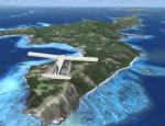
FSX Fiji Photoreal Package - Western Division 3 (Yasawas Part1)
(Category: FSX > Scenery)
200.30Mb (1725 downloads)
FSX Fiji Photoreal Package - Western Division 3 (Yasawas Part1)
Fiji is an island nation in the South Pacific with more than 300 islands in total.
Fiji is divided into four major administrative divisions: Western, Central, Northern
and Eastern. These Western Division scenery packages cover the entire area of
the Western Division. Included are more than 40 islands and huge areas of reefs
stretched over a total area of 20,000 sq km – all in photoreal, 1m/pixel
texture resolution. List of islands included in this package: Jiliva, Kuata, Naviti,
Waya, Wayasewa, Viwa. By Tiberius Kowalski
Posted Jan 3, 2013 06:14 by TK

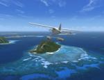
FSX Fiji Photoreal Scenery Package - Western Division 2 (Mamanucas)
(Category: FSX > Scenery)
229.53Mb (1689 downloads)
FSX Fiji Photoreal Scenery Package - Western Division 2 (Mamanucas)
Fiji is an island nation in the South Pacific with more than 300 islands in total.
Fiji is divided into four major administrative divisions: Western, Central, Northern
and Eastern. These Western Division scenery packages cover the entire area of
the Western Division. Included are more than 40 islands and huge areas of reefs
stretched over a total area of 20,000 sq km – all in photoreal, 1m/pixel texture
resolution. List of the 23 islands included in this package: Beachcomber, Bounty,
Castaway, Eori, Kodomo, Mala Mala, Malolo-Lalai, Mana, Matamanoa, Monu, Monuriki,
Namotu, Nautanivono, Navini, South Sea, Tavua, Tavarua, Tivua, Tokuriki, Treasure,
Vanua Levu, Vomo, Yanuya. By Tiberius Kowalski
Posted Jan 3, 2013 03:15 by TK

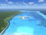
FSX Fiji Photoreal Scenery Package - Western Division 1 (Vatulele)
(Category: FSX > Scenery)
32.59Mb (1437 downloads)
FSX Fiji Photoreal Scenery Package - Western Division 1 (Vatulele)
Fiji is an island nation in the South Pacific with more than 300 islands in total.
Fiji is divided in four major administrative divisions: Western, Central, Northern
and Eastern. These Western Division scenery packages cover the entire area of
the Western Division. Included are more than 40 islands and huge areas of reefs
stretched over a total area of 20,000 sq km – all in photoreal, 1m/pixel
texture resolution. List of islands included in this package: Vatulele By Tiberius
Kowalski
Posted Jan 3, 2013 01:47 by TK
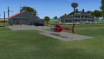
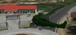
Big Dawg Heliport and Practice Area
(Category: FSX > Helicopters)
0.07Mb (2556 downloads)
Your own house and hanger and your own private practice area for helicopters. By BigDawg205.
Posted Jan 3, 2013 00:08 by BigDawg 205
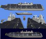
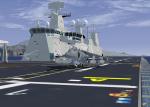
LHD Juan Carlos I Aircraft Carrier
(Category: FSX > Misc)
16.23Mb (3097 downloads)
Spanish Armada LHD Juan Carlos I. To be used with AIcarriers. Improved version of previous releases by jagl04
Posted Jan 2, 2013 18:51 by jagl04
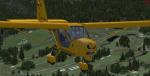

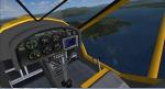
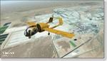
Aeroprakt A-22 Foxbat
(Category: FSX > Props)
9.27Mb (5988 downloads)
Aeroprakt A-22 Foxbat.
The A-22 'Foxbat' is available as a Ready-To-Fly factory built aircraft or as an advanced kit. Building time for the kit is 300 to 500hrs. Designed by former Antonov design engineer, Yuri Yakovlev , the A-22 is one of a line of many aircraft produced by Aeroprakt in the Ukraine. Construction is aluminium with some parts of the wing and control surfaces covered with Ceconite. The A-22 is powered by the reliable Rotax 912 or 912S engine, and the 3-blade composite ground adjustable propellor from KievProp is very quiet. A cabin width of 120cm (128cm at the elbows) ensures ample room for pilot and passenger. As a comparison, the cabin with of a Cessna 172 is 100cm and a Jabiru SP is 97cm (107cm at the elbows). Transparent doors with convex sides allow for excellent downward visibility. The instrument panel has room for a generous instrument layout. Dual controls are standard with options of either conventional control yokes or a centre stick. A centre stick with a "Y" grip is also available. Basic VFR flight and engine instruments are included with the ready-to-fly aircraft. A stall speed of 50kph (30mph) using the full span flapperons puts the A-22 safely into the microlight category. The all round visibility from the A-22 is spectacular. The aircraft has a baggage compartment that allows up to 20kg to be carried.
Posted Jan 2, 2013 14:41 by uploader

Aeroprakt A-22 Foxbat Ultralight
(Category: FSX > Props)
9.27Mb (2575 downloads)
Aeroprakt A-22 Foxbat.
The A-22 'Foxbat' is available as a Ready-To-Fly factory built aircraft or as an advanced kit. Building time for the kit is 300 to 500hrs. Designed by former Antonov design engineer, Yuri Yakovlev , the A-22 is one of a line of many aircraft produced by Aeroprakt in the Ukraine. Construction is aluminium with some parts of the wing and control surfaces covered with Ceconite. The A-22 is powered by the reliable Rotax 912 or 912S engine, and the 3-blade composite ground adjustable propellor from KievProp is very quiet. A cabin width of 120cm (128cm at the elbows) ensures ample room for pilot and passenger. As a comparison, the cabin with of a Cessna 172 is 100cm and a Jabiru SP is 97cm (107cm at the elbows). Transparent doors with convex sides allow for excellent downward visibility. The instrument panel has room for a generous instrument layout. Dual controls are standard with options of either conventional control yokes or a centre stick. A centre stick with a "Y" grip is also available. Basic VFR flight and engine instruments are included with the ready-to-fly aircraft. A stall speed of 50kph (30mph) using the full span flapperons puts the A-22 safely into the microlight category. The all round visibility from the A-22 is spectacular. The aircraft has a baggage compartment that allows up to 20kg to be carried.
Posted Jan 2, 2013 13:57 by uploader
Borax Open Pit Mine, California
(Category: FSX > Scenery)
59.80Mb (984 downloads)
Photoreal coverage of Borax Open Pit Mine near Edwards AFB in California. Scenery includes blend masks, water masks, and night textures.
Posted Jan 2, 2013 02:41 by Chuck79
Changuinola FS-X
(Category: FSX > Scenery)
17.70Mb (443 downloads)
MPCH scenery for FSX.
Airport located in Changuinola, Bocas Del Toro, Panama
Posted Jan 2, 2013 01:27 by Victor Pinto
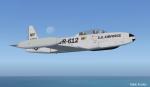
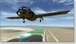
TR-612 USAF T33
(Category: FSX > Military)
17.92Mb (4293 downloads)
This is Tim Conrad's T-33 Updated For Flight Simulator X. Design work for the Lockheed P-80 began in 1943 with the first flight on 8 January 1944. Following on the Bell P-59, the P-80 became the first jet fighter to enter full squadron service in the United States Army Air Forces. As more advanced jets entered service, the F-80 took on another role - training jet pilots. The two-place T-33 jet was designed for training pilots to fly jets. This Aircraft belongs to the United States Air Force. This Aircraft has a new 2D and 3D fully functioning cockpits and new Effects. Textures and Updates by Mark " Fireball " Rooks of RDG Aircraft. Package Includes Pictures of the original TR-612 Aircraft Currently located In South Ga.
Posted Jan 1, 2013 00:27 by Mark Fireball Rooks