


All Files > Page 1565
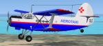
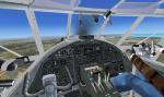
FSX Antonov AN-2 Aerotaxi (Cuba) with VC
(Category: FSX > Vintage)
24.49Mb (7097 downloads)
FSX Aerotaxi Antonov AN-2 with virtual cockpit (VC). Aerotaxi is a Cuban charter airline that operates several AN-2's (and DC-3's) on tourist/scenic flights as well as mail/cargo deliveries. This package includes the entire aircraft. Excellent model by V. Zhyhulskiy. Aerotaxi repaint by kilocharlie1.
Posted Dec 12, 2012 08:56 by kilocharlie1
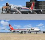
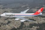
Boeing 747-8 Cargolux Freighter Delux Package
(Category: FSX > Civil Jets)
69.91Mb (7561 downloads)
FSX SkySpirit2012 Boeing 747-8 Freighter Delux Package,
in Cargolux Livery, registration LX-VCA
Assembled and edited for FSX with the developed B747 VC from Alejandro Rojas Lucenda. This is the Skyspirit FSX Boeing 747-8F cargo model updated November 2012, and includes ground cargo servicing, stairs (FSX - Go to Views - Instrument Panel -Posky Utility), jetway (Ctrl J), opening nose section and more.
Included CF engine sounds from BrandonG, with realistic jet whine to make your flight sound great.
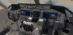
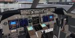
Upgraded using the vastly improved Boeing 747 VC from Alejandro Rojas Lucena/FSND (See panel docs for details). VC includes FMC, EICAS, MFD with control panel, GPWS, working wipers, cabin lights, fire suppression, avionics switch, fuel crossfeed, landing lights switches, taxi light switch, engine generators, APU generator, battery switch, starter switches, de-ice switch, general lights switches.
Thank you to Skyspirit for their outstanding donations to the worldwide community of flight simulation. Beautiful Cargolux textures by Carlos Eduardo Salas. Enhanced shine to give a freshly cleaned look.
Also includes the Boeing 747 VC textures upgrade. This give a much clearer 747 interior virtual cockpit look.
Assembled and edited for FSX by Chris Evans.
Zip preview for larger pictures.
See panel docs and images for VC details and controls
Posted Dec 12, 2012 08:49 by Chris Evans
Boeing 747-8 Freighter Cargolux
(Category: FS2004 > Civil Jets)
22.52Mb (1901 downloads)
Skyspirit2012 747-8F V2
FS2004 SkySpirit2012 Boeing 747-8 Freighter,
in Cargolux Livery, registration LX-VCA.
Textures by Carlos Eduardo Salas
Update model created by Hiroshi Igami
Posted Dec 12, 2012 07:40 by Chris E
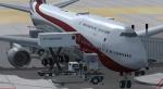
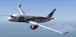
Boeing 747-8i Qatar Business Jet Delux Package
(Category: FSX > Civil Jets)
67.52Mb (5229 downloads)
FSX SkySpirit2012 Boeing 747-8 Intercontinental,
in The State Of Qatar Delux Package.
Assembled and edited for FSX with the developed B747 VC from Alejandro Rojas Lucenda.
This is the Skyspirit FSX Boeing 747-8i model updated November 2012, and includes
ground cargo servicing, stairs (FSX - Go to Views - Instrument Panel -Posky Utility),
jetway (Ctrl J).
Included CF engine sounds from BrandonG, with realistic jet whine to make your flight
sound great.
Upgraded using the vastly improved Boeing 747 VC from Alejandro Rojas Lucena/FSND (See
panel docs for details). VC includes FMC, EICAS, MFD with control panel, GPWS, working
wipers, cabin lights, fire suppression, avionics switch, fuel crossfeed, landing
lights switches, taxi light switch, engine generators, APU generator, battery switch,
starter switches, de-ice switch, general lights switches.
Thank you to Skyspirit for their outstanding donations to the worldwide community of
flight simulation. Beautiful VQ-BSK Qatar textures by Carlos Eduardo Salas.
Also includes the Boeing 747 VC textures upgrade. This give a much clearer 747
interior virtual cockpit look.
Assembled and edited for FSX by Chris Evans.
Zip preview for larger pictures.
See panel docs and images for VC details and controls!
Posted Dec 12, 2012 07:31 by Chris Evans

Bombardier C Series C110 & Cia
(Category: FS2004 > Civil Jets)
7.42Mb (1797 downloads)
NHL CSeries C110 Bombardier's aircraft for the 110 market, TU-414 Superior business jet and ARJ21-700 Regional jet, China. Model and textures by J R Lucariny
Posted Dec 11, 2012 12:36 by archive
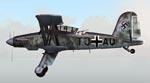
Fieseler Fi-167
(Category: FS2004 > Vintage)
2.31Mb (767 downloads)
Fi-167 German Carrier-based Torpedo bomber. Model and textures by J R Lucariny
Posted Dec 11, 2012 12:16 by JRLucarinyFS2004Models
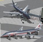
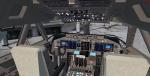
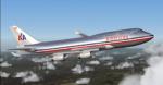
American Airlines Boeing 747-423 Delux Package
(Category: FSX > Civil Jets)
59.13Mb (9418 downloads)
American Airlines Boeing 747-423 Delux Package.
Assembled and edited for FSX with the developed B747 VC from Alejandro Rojas Lucenda. This is the Project Opensky native FSX Boeing 747-400 model, including ground cargo servicing, stairs (FSX - Go to Views - Instrument Panel -Posky Utility), jetway (Ctrl J).
Included CF engine sounds from BrandonG, with realistic jet whine to make your flight sound great.
Upgraded using the vastly improved Boeing 747 VC from Alejandro Rojas Lucena/FSND (See panel docs for details). VC includes FMC, EICAS, MFD with control panel, GPWS, working wipers, cabin lights, fire suppression, avionics switch, fuel crossfeed, landing lights switches, taxi light switch, engine generators, APU generator, battery switch, starter switches, de-ice switch, general lights switches.
Thank you to Skyspirit for their outstanding donations to the worldwide community of flight simulation. Beautiful AA textures by Xudeva Irribarra. Added reflections to give a polished finish.
Also includes the Boeing 747 VC textures upgrade. This give a much clearer 747 interior virtual cockpit look.
Assembled and edited for FSX by Chris Evans.
Zip preview for larger pictures.
See panel docs and images for VC details and controls
Posted Dec 11, 2012 09:22 by Chris Evans
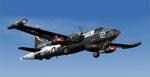
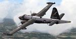
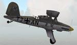
Lockheed P2V-7/P-2H
(Category: FS2004 > Military)
6.37Mb (3326 downloads)
Lockheed P2V-7/P-2H. P2V-7S Maritime patrol and ASW aircraft. Model and textures by J R Lucariny
Posted Dec 11, 2012 08:41 by JRLucarinyFS2004Models
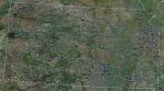
FSX Kansas Airfield Locator
(Category: FS Navigation > Flight Simulator Navigation)
2.78Mb (96 downloads)
Tested on Windows XP and Windows 7.
This download adds airfield markers and ICAO id's found in FSX, and overlays them on Google Earth.
This file is for Kansas. USA.
There is also a seperate file with a list of basic airfield location details.
i.e: EGBB Birmingham Airport. Birmingham. N52* 27.23' W1* 44.88' alt325.
Also the tidying "My places" in Google Earth, file.
Other locator files to follow.
by Carl Vokes
Posted Dec 11, 2012 08:29 by carl vokes
Boeing 747-400 American Airlines
(Category: FS2004 > Civil Jets)
13.01Mb (2435 downloads)
Boeing 747-400 American Airlines for fs2004
This is a repaint of the Project Opensky 747-400 v4 in American Airlines fictional Livery by Xudeva Irribarra.
Posted Dec 11, 2012 08:08 by Chris E