


All Files > Page 1577
Germany - EDKL - Leverkusen
(Category: FSX > Scenery)
3.29Mb (1476 downloads)
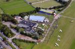
GERMANY - EDKL (Leverkusen-Kurtekotten) Version 0.4 This is the first airfield, that I've created with Airport Design Editor (ADE) of Jon Masterson. I've tried to do the joby as close as possible to reality. Nevertheless, I'm mainly using standard FSX library objects, so that the exact look, the colour of buildings and other objects will differ. In the archive you'll find some aerial photos of the real airfield, so that you can give yourself your own impression of how well the work has succeeded. - - - !! Important: In order to function properly, this scenery necessarily needs a free, third-party library, which you have to install too !! If you don't install this library, most of the objects of the scenery will NOT BE DISPLAYED !!! You can download this free library at: http://www.flightport.de/index.php?id=369 Scroll down a little bit and klick on "Download FlightPort-Gmx-Lib 4.2.7" I have the permission of the library designers to use this fine stuff...:-)
Posted Nov 22, 2012 00:32 by Dirk Cremer
FSX Montana Airfield Locator
(Category: FS Navigation > Flight Simulator Navigation)
2.66Mb (126 downloads)
Tested on Windows XP and Windows 7.
This download adds airfield markers and ICAO id's found in FSX, and overlays them on Google Earth.
This file is for Montana. USA.
There is also a seperate file with a list of basic airfield location details.
i.e: EGBB Birmingham Airport. Birmingham. N52* 27.23' W1* 44.88' alt325.
Also the tidying "My places" in Google Earth, file.
Other locator files to follow.
by Carl Vokes
Posted Nov 21, 2012 15:44 by carl vokes
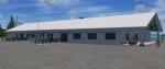
Rock Sound - The Bahamas (MYER)
(Category: FSX > Scenery)
1.19Mb (1118 downloads)
Rock Sound - The Bahamas (MYER)
This scenery includes rework of the runway, taxiways, aprons and parking; custom scenery objects; placement of library objects and landclass changes. It is based on Google Earth imagery and photos taken by Harrington Mallory. By: Art Poole
Posted Nov 21, 2012 15:42 by art poole

FSXCFG Tool v1.05 For Flight Simulator X
(Category: FSX > Utilities)
2.06Mb (2917 downloads)
FSX Utility - FSXCFG Tool v1.05 For Flight Simulator X
A utility to allow the editing your FSX.CFG file.
Gives the user full editing suite with a full
audit trial to allow the user to view and restore previous settings.
Bulk import settings easily, options to remove old gauges and module
references and to backup CFG. Full documentation included.
By Mark Bradshaw
Posted Nov 21, 2012 15:33 by uploader
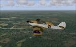
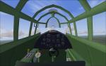
Hawker Hurricane Mk.Ia Bardufoss
(Category: FSX > Vintage)
7.45Mb (849 downloads)
Hawker Hurricane Mk.Ia, 46 squadron, Bardufoss, Norway, 1940. Original CFS2 model by Thicko, new Bardufoss-textures by Pombee, now updated for FSX. Full working VC, all necessary gauges included. Gun-effects for fun. Enjoy!
Posted Nov 21, 2012 13:01 by erik hertzberger
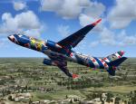
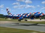
Level D Boeing 767-300 Coca Cola Promotions Textures
(Category: FSX > Payware)
5.12Mb (351 downloads)
Coca Cola Promotions textures for the payware Level D Boeing 767-300ER
This are two liveries of the Coca Cola Promotions an Boeing 767-300ER Winglet.
Textures by Peter Franeker.
Posted Nov 21, 2012 08:58 by Peter Franeker
Level D Boeing 767-300ER Friesland Promotions Textures
(Category: FSX > Payware)
2.58Mb (144 downloads)
Friesland Promotions textures for the payware Level D Boeing 767-300ER.
Textures by Peter Franeker.
Posted Nov 21, 2012 07:44 by Peter Franeker
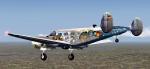
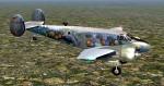
FS2004 (FSX) Beech D18S Aero Astro Design
(Category: FS2004 > Props)
43.83Mb (1997 downloads)
FS2004 (also works in FSX) Beech D18S Aero Astro Design. This is a complete aircraft with two Aero Astro Design liveries (German and US) for the great Beech D18S aircraft with VC by Milton Shupe. Repaints by Ingo Schwan.
Posted Nov 21, 2012 05:56 by Ingo Schwan
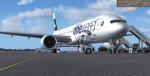
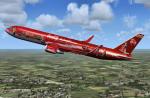
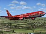
Boeing 777-300ER Cathay Pacific Airways/Oneworld Package
(Category: FSX > Civil Jets)
31.48Mb (7721 downloads)
Boeing 777-300ER with the Cathay Pacific Airways/Oneworld. Features are Opening doors & Cargo doors, detailed textures, accurate paint, dynamic shine & effects, dynamic flexing wings that respond to turbulence, fully independent suspension, trim animation, gear steering, accurate flight dynamics, spoiler animation, reflective cockpit windows, crash effects, animated tilting bogies, full night lighting, ground service vehicles when cargo
door open, (FSX - Go to Views - Instrument Panel -Posky Utility), detailed virtual cockpit and more. Model, VC model by Project Opensky and textures by Juan Rodriguez. Mods for FSX by Chris Evans.
Posted Nov 20, 2012 10:24 by Chris Evans


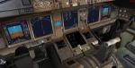
FSX A321 VC Night Lights
(Category: FSX > Panels)
2.94Mb (7265 downloads)
Replacement VC lighting for the FSX A321, to make night flying more enjoyable.
The default dome lighting was far too bright so this has been brought down to a realistic level. In addition to this most of the display lighting has been replaced with a blue/white LED style including a small glow effect. The overall mod means you can now enjoy night flying and the instrument lighting. Check out the before and after pictures in the
File info
Posted Nov 20, 2012 05:52 by Paul Davies