


All Files > Page 1636
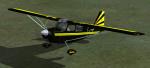
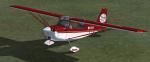
FSX/FS2004 Bellanca Decathlon Black and Yellow Textures
(Category: FSX > Props)
0.92Mb (305 downloads)
FSX/FS2004 Textures only for Long Island Classics Decathlon for fsx and fs9 Black and Yellow livery. Enjoy and Happy Flying
Posted Aug 20, 2012 10:37 by Lloyd Horton
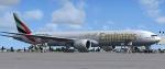
FSX Emirates B777-31H 1000th with VC
(Category: FSX > Civil Jets)
55.69Mb (20265 downloads)
FSX Emirates B777-31H 1000th with VC
FSX native model Emirates B777-31H 1000th. Textures include realistic
shadow, shine and reflective effects. Featuring 32bit Highly Detailed graphics
with night light effects. The model includes all the usual things as a steering
nosewheel, taxi and landing lights, dynamics shine and all moving parts,
including a fully animated landing gear animation. Some special things include
three opening doors, with visible interior. Ground service when cargo doors open (Shift E 2) Added jetway edits (Ctrl J). VC and FSX native model. Flexing wings, wing views and
trim animation for the horizontal stabilisers. Model, dynamics by: Project Opensky,
Repaint By: A.Polash. Updated for FSX by Chris Evans.
Posted Aug 20, 2012 06:34 by chris evans

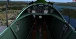
Dart Kitten II
(Category: FSX > Vintage)
14.05Mb (2129 downloads)
Dart Kitten II for FSX Full animations, 3D gauges and Baked Textures. Dart Kitten was an ultra-light single-seat low-wing aircraft, built in 1936, with a fixed tailskid undercarriage. The four examples built were powered by a variety of engines of between 27 h.p. and 40 h.p.[1]By Craig Richardson @ www.Classicwings.net
Posted Aug 20, 2012 04:47 by uploader
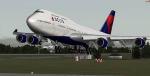
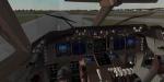
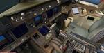
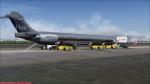
Boeing 747-451 Delta Airlines 2007 Colors BH N665US with Enhanced VC
(Category: FSX > Civil Jets)
30.04Mb (10455 downloads)
Boeing 747-451 Delta Airlines 2007 Colors BH N665US with Enhanced VC
Skyspirit FSX native Boeing 747-400 passenger model upgraded using the vastly improved Boeing 747 VC from Alejandro Rojas Lucena/FSND (See panel docs for details). VC includes FMC, EICAS, MFD with control panel, GPWS, working wipers, cabin lights, fire suppression, avionics switch, fuel crossfeed, landing lights switches, taxi light switch, engine generators, APU generator, battery switch, starter switches, de-ice switch, general lights switches. Beautiful Skyspirit 747-800 Freighter model with complex features and ground service vehicles (press shift e 2, shift e 3, etc. ). Textures by Project Opensky member.
Also includes Boeing 747 upgraded VC textures by Jason A. Lee. This gives a much clearer 747 interior look.
Assembled and edited for FSX by Chris Evans.
Zip preview for larger pictures.
See panel docs and images for VC details and controls!
Posted Aug 19, 2012 09:25 by chris evans
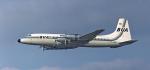
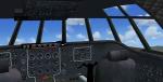
Bristol Britannia Mega Pack
(Category: FSX > Props)
72.85Mb (5815 downloads)
This JBK Britannia mega package is in celebration of the 60th anniversary of the first flight on the 16th august 1952 . With its 4 turboprop engines it soon got the nick name Whispering Giant. There are 15 liveries from various painters including seven new paintings by myself. VC and 2D panel included. Original by Jens B. Kristensen
Posted Aug 18, 2012 22:42 by Stephen Browning
Bellanca Super Decathlon Bush Flying Unlimited Textures
(Category: FSX > Props)
0.84Mb (482 downloads)
Textures for Long Island Classics Decathlon in fictional Bush Flying Unlimited livery. Works with the FS2004 model also. Requires the full Decathlon.
Posted Aug 18, 2012 22:37 by Lloyd Horton
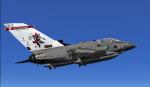
RAF Tornado GR4 41 Sqn Olympics 2012 Textures
(Category: FSX > Military)
0.67Mb (3396 downloads)
FSX 41 Sqn Olympics 2012 textures for the UKMil Tornado GR4.
This pack includes textures for ZA614 of 41 SQN RAF Coningsby.
Requires the UKMil Tornado GR4 package.
Textures by UKMIL [http://WWW.UKMIL.ORG.UK]
Required files:
required file
Posted Aug 18, 2012 21:52 by UKMIL
Jet City MD 88 US Air Textures
(Category: FS2004 > Payware)
9.24Mb (362 downloads)
US Air Textures only for the payware Jet City MD88
Posted Aug 18, 2012 21:45 by LUIS CASTRO
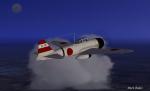
A6M2 Zero A1-101
(Category: FSX > Vintage)
12.67Mb (4338 downloads)
This is an updated version of J R Lucariny's FS2004 A6M for FSX. The Japanese Mitsubishi A6M Zero fighter, which began production in 1940. It's excellent maneuverability and exceptional range allowed it to outperform all other fighters that it encountered in the first years of World War II But as the war drew longer the Zero lost it's advantage. Tail Code A1-101 Textures by Mark Rooks. 2d panel but no VC.
Posted Aug 18, 2012 21:34 by Mark Fireball Rooks
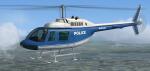
FSX Bell 206B JetRanger Generic 'Police' Textures
(Category: FSX > Helicopters)
4.46Mb (1222 downloads)
Textures for the default Bell 206B JetRanger repaint textures in a generic police blue
and white livery. Awaiting the addition of the call sign letters of your choice,
denoting the law enforcement jurisdiction of your choice. Or you can fly her
as is. Easy installation. Repaint by Tom Tiedman.
Posted Aug 18, 2012 19:33 by Tom Tiedman