


All Files > Page 1653
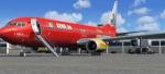
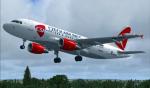
Boeing 737-800w Tuifly (Cewe Fotobuch-cs) Package
(Category: FSX > Civil Jets)
19.54Mb (3440 downloads)
Project Opensky Boeing 737-800w Tuifly (Cewe Fotobuch-cs)
for Microsoft Flight Simulator X
Skyspirit/Project Opensky native FSX Boeing 737-800 model.
Upgraded to FSX using the Alejandro Rojas Lucena/FSND revised Boeing 737-800 VC. This model includes Working wipers (right mouse click on switch) with rain effect. Switches for LCD Screens, EICAS, PFD, MFT. Autobrake switch. Opening pilots window. Cabin Lights switch. Realistic FMC. Ground Proximity Warning System (GPWS), More Realistic night textures.
FSX native model winglet by Skyspirit/Project Opensky. VC by MS/Alejandro Rojas Lucena/FSND.
Textures by Mathieu Vos.
Modified for FSX by Chris Evans.
Posted Jul 23, 2012 15:01 by Chris Evans
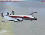
FSX/FS2004 Lockheed L-1049E Constellation IberiaTextures
(Category: FS2004 > Props)
4.05Mb (1075 downloads)
This repaint was one of ten IBERIA's units of Super Constellation: EC-AIN. "Santa Maria" 1049 E-55 (Serial number S/N 4550). A repaint of Manfred Jahn's outstanding Lockheed L-1049 Super G Constellation.
Required files:
required file
Posted Jul 23, 2012 02:51 by Enrique Medal
Airbus A319 Czech Airlines
(Category: FSX > Civil Jets)
63.68Mb (3267 downloads)
Project Airbus Czech Airlines A319 OK-PET for FSX.
Includes default VC, upgraded by Jim Fly.
You can find this aircraft under 'Project Airbus' in your FSX menu.
Posted Jul 23, 2012 02:23 by Jim Fly
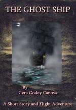
Ghost Ship of the Southern Seas
(Category: FSX > Missions)
0.94Mb (3705 downloads)
This is not a "Mission", its a story of an expedition is South Chile and you will be in the middle of it together with Max Rex, Dr. Buenas and a beautiful lady..." " Santiago tower this is CP559 about twenty miles from your station to land" Max shut the microfone and waited through the radio static a responce. After a few seconds a noice crackling voice said " CP559, land as you see fit, there is a large thunderstorm over the city but two planes just landed without much problema, be on the lookout for lighting"..So the story starts!!!!....
Posted Jul 23, 2012 02:15 by Gera Godoy Canova
Spike's Landing And Taxi Light Gauge
(Category: FS Gauges > FS Gauges)
0.23Mb (472 downloads)
Tired of fiddling with landing light switches on approach?? Use both landing and taxi lights when landing a small aircraft?? Then here’s a handy gauge for you! Add this to any aircraft and when you toggle the landing lights the taxi will also come on for more lighting power. Once on the ground turn off your landing lights off again and the taxi lights stay on (until you turn them off) making lighting control easy.
I made this gauge work only when the aircraft is airborne thus still allowing full lighting control on the ground.
Posted Jul 23, 2012 02:01 by Spike
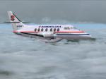
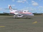
Virtualcol PAWA Dominicana British Aerospace Jetstream 31 (HI841) Textures
(Category: FS2004 > Payware)
1.07Mb (224 downloads)
British Aerospace Jetstream 31,(cn 674), registration HI841, wearing the last
colors used by PAWA in its Jetstream 31. Fully reworked textures only for the
Virtualcol BAe Jetstream 31 model (payware package). Look at
http://products.virtualcol.com/ for detailed info. By Juan Ernesto Oropeza.
Posted Jul 23, 2012 01:58 by Juan Ernesto Oropeza
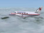
Virtualcol PAWA Dominicana British Aerospace Jetstream 31 (HI817) Textures
(Category: FS2004 > Payware)
1.28Mb (174 downloads)
British Aerospace Jetstream 31,(cn 673), registration HI817, wearing the last colors used by PAWA in its Jetstream 31. Fully reworked textures only for the
Virtualcol BAe Jetstream 31 model (payware package). Look at http://products.virtualcol.com/ for detailed info. By Juan Ernesto Oropeza.
Posted Jul 23, 2012 01:56 by Juan Ernesto Oropeza


3U2 Johnson Creek Airport, Idaho
(Category: FSX > Scenery)
12.69Mb (1112 downloads)
"Johnson Creek Airport (FAA LID: 3U2) is a grass airstrip located in Central Idaho three miles (5 km) south of Yellow Pine, a village in Valley County, Idaho, United States. It is managed by the Idaho Division of Aeronautics of the Idaho Transportation Department. A caretaker resides at the field, and as a result, the turf runway is well cared for. Johnson Creek is in the category of backcountry airstrips, and is popular with pilots who enjoy airplane camping." - Wikipedia
This FSX rendition includes volumetric grass, static aircraft, 1 meter/pixel photoscenery, 10 meter mesh, full autogen annotation, and is color corrected and blended into the surrounding scenery.
Posted Jul 22, 2012 16:08 by Orion Lyau
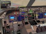
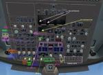
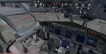
FSND FSX Boeing 747 Upgraded Virtual Cockpit
(Category: FSX > Panels)
17.65Mb (52873 downloads)
FSND FSX Boeing 747 Upgraded Virtual Cockpit.
An upgrade to replace the old default FSX Boeing 747-400 virtual cockpit. This revolutionizes your 747 VC!
FMC, EICAS, MFD with control panel, GPWS, working wipers, cabin lights, fire suppression, avionics switch, fuel crossfeed, landing lights switches, taxi light switch, engine generators, APU generator, battery switch, starter switches, de-ice switch, general lights switches, and more! PDF file illustrated information. (BACK UP YOUR ORIGINAL!). FMC by Garrett Smith. GPWS by Rob Barendregt. Original VC Created and produced by:
Alejandro Rojas Lucena.
Posted Jul 22, 2012 04:48 by Alejandro Rojas Lucena
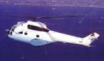
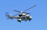
Philippine Air Force AS332 Super Puma
(Category: FS2004 > Helicopters)
4.64Mb (3370 downloads)
FS2004 Philippine Air Force Eurocopter AS332 Super Puma
Philippine Air Force's 252nd Helicopter Squadron of the 250th Presidential Airlift Wing
based in Villamor Air Base. The only Puma helicopter in the inventory of the PAF. A
medium transport helo, France in origin with the capability to operate day or night in
all weather, all climate. It has a large cabin, a crew of 2 and 16-20 troops or 6
stretchers. It has a speed of 163 mph and a range without reserves of 342 miles powered
by a 4-bladed rotor.Helicopter has NO VC but stable flight dynamics and easy to hover.
Capable to make a spot landing.
Base model: FS2004 Eurocopter AS332 Super Puma Japan Coast Guard
This model was built with Gmax.
Visual Model by K.Furuya
Original exterior sound are from Olle Kauppi
Easy Autopilot gauge by Martin “Gizmocat” Benson, Dirk Fassbender and Antti Pankkonen
Sound by Dirk Fassbender
2D cockpit panel by Brian Franklin
Repainted by: Gerard G. Olvis
Posted Jul 21, 2012 23:11 by Gerard G. Olvis