


All Files > Page 1650
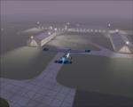
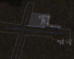
Spike's Bacchus Marsh, Victoria, Australia MOD Spike's Bacchus Marsh, Victoria, Australia MOD (Revised)
(Category: FS2004 > Scenery)
11.38Mb (438 downloads)
99.9% of pilots in Melbourne, Victoria, Australia know about YBSS. It's the classic aerodrome of Bacchus Marsh and has been around for years supporting many-a-sailplane and flying school. I’ve done my best to reproduce this airfield as it appears now. (Taken from my ERSA and online photos). Includes objects, Summer & Winter landclass maps. Includes pre-compiled AI traffic and bonus YMFD Mansfield Airfield ready to go!
Posted Jul 25, 2012 21:48 by Spike

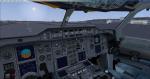
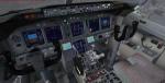
Boeing 767-200ER American Airlines - New VC
(Category: FSX > Civil Jets)
42.01Mb (9438 downloads)
The Skyspirit2010 Boeing 767-200ERV5 model with the spectacular Tom Ruth A310 VC. Contains the default panel and my revised panel. Enjoy!
Posted Jul 25, 2012 19:11 by Skilaeb Dygsbi
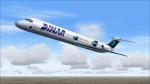
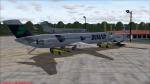
Jet City DC-9-51 Dinar Lineas Aereas Textures
(Category: FS2004 > Payware)
6.12Mb (236 downloads)
DC-9-51 Dinar Lineas Aereas 1999 textures only for the payware Jet City model.
Posted Jul 25, 2012 16:44 by LUIS CASTRO
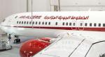
Air Algerie Boeing 737-800 Textures
(Category: FSX > Civil Jets)
1.80Mb (4259 downloads)
Air Algerie textures only for the default FSX Boeing 737-800
Posted Jul 25, 2012 15:40 by LOTFI ABDELGHANI ALGERIAN OF EL MADANIA
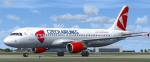
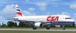
Airbus A320 CSA Czech Airlines
(Category: FSX > Civil Jets)
60.84Mb (5435 downloads)
Project Airbus Air Czech Airlines OK-GEA for FSX.
Includes default VC, upgraded by Jim Fly.
You can find this aircraft under 'Project Airbus' in your FSX menu.
Posted Jul 25, 2012 05:41 by Jim Fly
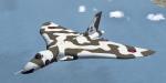
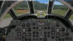
Avro Vulcan B MK.2 XH558
(Category: FSX > Military)
7.42Mb (4926 downloads)
This aircraft is a legend! XH558 is the last Avro Vulcan bomber still flying. This is due to the great job of the "Vulcan to the Sky" club and this realisation is dedicated to them. Original model by Phoenix Design. Adaptation to FSX, textures, photorealistic panel (no VC) including GPWS callouts by Philippe Wallaert. See instructions for installation and configuration in the readme.txt file. Credits: Phoenix Design for the original model. Enjoy!
Posted Jul 25, 2012 02:49 by Philippe Wallaert
REAL STS-109 Entry and Landing scenarios
(Category: Space Orbiter > Orbiter Addons)
0.00Mb (1254 downloads)
These are historically accurate scenarios for the entry and landing of STS-109; the final approach scenarios on Orbithangar are not accurate. This package was originally released on the Orbiter Forum, but is being distributed here for everyone.
Posted Jul 24, 2012 19:08 by David413
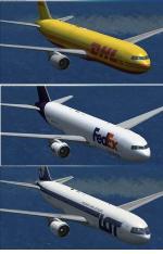
Boeing 767-300 GE CF6 Multi Package
(Category: FSX > Civil Jets)
93.91Mb (11733 downloads)
This package includes passenger and cargo variants of the Skyspirit2010 767-300ER V5 model. Equipped with the upgraded 737 VC by Alejandro Rojas Lucena/FSND and includes working wipers (right mouse click on switch) with rain effect. Switches for LCD Screens, EICAS, PFD, MFT. Autobrake switch. Opening pilots window. Cabin Lights switch. Realistic FMC. Ground Proximity Warning System (GPWS). Comes with 6 liveries: Fedex, UPS, DHL, LOT Polish Airlines, Aeroflot and a special deteriorating Delta livery. Enjoy!
Posted Jul 24, 2012 10:37 by Skilaeb Dygsbi
Airbus A320 Czech Airlines
(Category: FSX > Civil Jets)
60.06Mb (1687 downloads)
Project Airbus Czech Airlines A320 OK-LEF for FSX.
Includes default VC, upgraded by Jim Fly.
You can find this aircraft under 'Project Airbus' in your FSX menu.
Posted Jul 24, 2012 06:10 by Jim Fly
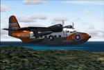
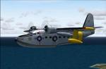
Grumman Albatross (short winged) UF-1/HU-16 Package
(Category: FS2004 > Props)
89.10Mb (3929 downloads)
FS2004 Grumman Albatross (short winged) UF-1/HU-16.The Albatross
started out as a company venture in the late forties and became such a success
that it has been used by more than two dozen armed forces throughout the
world.Original by Greg Pepper,and Michael Verlin.
Models by "Swingman",sounds by "Skysong Soundworks",and textures
by Michael Verlin. Some texture mods by James Craig. 4 different
models, 2d panel as well as VC, unique sounds, many textures, etc..
Posted Jul 24, 2012 06:09 by uploader