


All Files > Page 1663
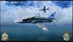
Skysim Hawk - 19 SQN 1992 Textures
(Category: FSX > Payware)
1.01Mb (604 downloads)
Textures for the payware Sky Sim Hawk T1A - Front seat only. I have recreated this texture from 19 Sqn T.1A hawk which is based at Chivanor in 1992.
Posted Jul 3, 2012 15:06 by Gordon Barnes
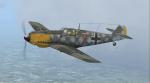
A2A WWII Fighters Bf109E Joachim Schypek Textures
(Category: FS2004 > Payware)
8.59Mb (282 downloads)
Historical Textures only for the Fs9 payware A2A Simulation WWII_Fighters_Bf109E
Bf-109E-4 W.Nr.1988 Oberleutnant Joachim Schypek 5./JG 54. Crashed 10 Hrs 15 on 25 October 1940 at Walls Farm ( Kent, UK ).
Posted Jul 3, 2012 10:49 by Mike Delizée
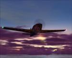
Spike's FS2004 Dawn Skies Update
(Category: FS2004 > Misc)
0.12Mb (999 downloads)
Add more red, magenta and purple to your FS2004 sky dawn appearance.
I made these files as I wasn't happy with the original sky at dawn as it has all this strange green light filling the sky. So i thought you might want this to add some more realistic colors. (Back up your original textures!)
Posted Jul 3, 2012 05:25 by Spike
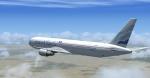
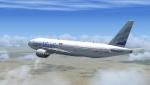
EuroAtlantic Boeing 767-300 Package
(Category: FSX > Civil Jets)
28.20Mb (6204 downloads)
EuroAtlantic Boeing 767-300ER Package. EuroAtlantic Airways had 15 Boeing's B767-332ER entered in 2000 and stored 13 in 2011, 2 still in service. FSX model by Skyspirit/ Project Opensky. Upgraded 737-800 VC by Alrot. Textures, merge & packaged by ricardo_tv
Posted Jul 2, 2012 21:19 by ricardo_tv
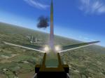
FSX Cameras and Weapon Effects for the Alphasim Bomber Douglas Boston
(Category: FSX > Vintage)
0.21Mb (706 downloads)
FSX cameras and weapon effects for the Alphasim Bomber Douglas Boston / A-20 Hacoc. There are views for the reargunner, for the bombardier, to the animated bombbay plus some external views. Required is the FS2004 Alphasim Douglas Boston plus a FSX panel. Configuration by Erwin Welker.
Required files:
BostonMkIII.zip
panel_ALPHABostonMkIII.zip
Required files:
required file
Posted Jul 2, 2012 13:59 by Erwin Welker
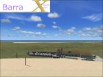
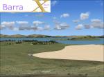
Barra Airport, Scotland, Scenery Package v.2.0
(Category: FSX > Scenery)
94.49Mb (3699 downloads)
Barra Airport, Barra Island, Scotland, (also known as Barra Beachport) is the unique airport which operates scheduled passengers flights on a beach. You can see British Airways, Flybe planes,( operated by Loganair) land on the sand. It's one of the most dangerous airport in the world. There is a small terminal, a car park, and 3 runways with red poles to sign where runway starts and finishes. Flights are operated in most of the time in the day, but sometimes you might find a night time flight. It operates when there's low tide, when the wind blows also just a bit or there's high tide, all flights are canceled. Usually are operated flights with a DHC 6 Twin Otter, which is one of a very few planes can land on the sand. The FSX default airport was wrong placed, with wrong runways and in the area of the real airport's place there was a bay. Now all is as right as possible! there are 3 runways, The airport has a custom terminal, a nice parking lot, and more...! We created for this airport an AI traffic, and it goes well! It has 2 ramps for planes. There is everything you need to enjoy this airport! Custom sand textures included plus new Landclass too!
Posted Jul 2, 2012 07:53 by Skara Scenery
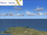
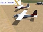
Fair Isle Airport, Scotland, Scenery Package
(Category: FSX > Scenery)
28.99Mb (1268 downloads)
Fair Isle Airport is a small airport located in Fair Isle, Shetland, Scotland. It is owned by the National Trust for Scotland. Fair Isle Aerodrome has a CAA Ordinary Licence that allows flights for the public transport of passengers. The aerodrome is not licensed for night use. The only runway is made up with gravel and the isle from the high is very suggestive, magic. The default airport was very poor, and it was a pity: a tiny runway in the middle of nothing. Now the airport look like the real and is alive with our customized traffic, a new and unique AI traffic, the island now is nice with the new shorelines and if you use a car you can have a trip around the mountains. The custom terminal appears the same of the real world's one and there's more.
Posted Jul 2, 2012 07:07 by Skara Scenery
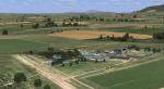
Diemerskraal South Africa
(Category: FSX > Scenery)
8.35Mb (1130 downloads)
Diemerskraal airstrip near Wellington in the Boland is a small privately owned airstrip on a farm with a dirt runway.It has a photoreal base that changes with the seasons.
Posted Jul 2, 2012 05:00 by Jacques Botha
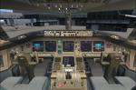
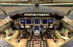
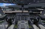
EuroAtlantic Boeing 777-200
(Category: FSX > Civil Jets)
67.27Mb (5419 downloads)
EuroAtlantic Boeing 777-200 package with VC. EuroAtlantic Airways had 3 Boeing's B777-212ER entered in 2012 with 1 still in service. Project Opensky Boeing 777-200 model with VC included(SMS + fsx gauges + VC).
Textures, merge & package by ricardo_tv
Posted Jul 1, 2012 17:55 by ricardo_tv
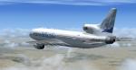
EuroAtlantic Lockheed L-1011 Package
(Category: FSX > Civil Jets)
21.91Mb (12791 downloads)
EuroAtlantic Airways main aircraft in history, had 1 Lockheed L1011-500 entered in 2000 and stored in 2010. Full model with VC. Thomas Ruth L-1011 with added DC-10 VC.
Textures, merge & packaged by ricardo_tv
Posted Jul 1, 2012 17:53 by ricardo_tv