


All Files > Page 1668
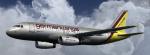
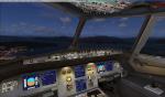
A319-112 German WIngs Package with vc
(Category: FSX > Civil Jets)
78.31Mb (5167 downloads)
This is an New version of the A319-112 German Wings with Virtual Cockpit for FSX.
Model by Project Airbus. Textures by : ©Fsx Designs, Wouter Hollanders
Posted Jun 30, 2012 05:48 by Wouter Hollanders
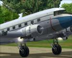
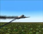
Spike's DC-3 with Engine Fire Effects
(Category: FS2004 > Vintage)
21.20Mb (2003 downloads)
FS2004 default DC-3 with added spike's engine fire and exhaust FX effects.
Prop dust and wheel dust by nick,
engine failure fire by Joe Latarski.
Posted Jun 30, 2012 02:22 by Spike
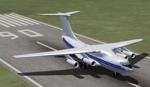
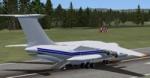
Views for the Ilyushin IL-76 cargo
(Category: FSX > Civil Jets)
0.10Mb (1917 downloads)
Views ( defined by camera definitions in the aircraft.cfg file ) for
the "FSX IL-76 Cargo" ( Ilyushin ) package. Original model by Sergey Varnavskiy.
Textures and updates by Mark Rooks of RSDG. NO VC !
13 outside views of the aircraft and a total of 3 virtual cockpit views ( front, left
right, no panels).
See Read me.txt file for very easy installation procedures.
Also included is a text file that contains the new camera definitions.
Enjoy !
Required files:
required file
Posted Jun 29, 2012 22:52 by Marc Renaud
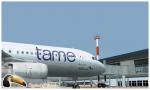
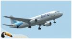
FS2004/FSX Airbus A320 Tame Textures
(Category: FS2004 > Civil Jets)
10.78Mb (1608 downloads)
Tame is the flag carrier of Ecuador with its headquarters located in Quito, Pichincha. TAME covers various routes in Ecuador and at an international level, the airline offers scheduled flights as well as charter flights. Photoreal textures in 32 bit format for the freeware Project Airbus A320 v2.1. Repaint be Manuel Jose. Happy flights.
Required files:
required file
Posted Jun 29, 2012 17:38 by Manuel Jose Larrahondo Burgos
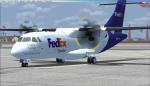
ATR42-300 Fedex Textures
(Category: FSX > Props)
1.23Mb (3463 downloads)
This is a repaint for the ISDT ATR 42-300 in the FedEx livery. Textures saved in 32 bit format with no mip maps. Credits can be found in the readme. Enjoy!
Required files:
required file
Posted Jun 29, 2012 16:39 by Sean
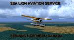
Sea Lion Air Services Scenery, Quebec
(Category: FSX > Scenery)
1.25Mb (1855 downloads)
Sainte-Anne-des-Monts is a city in the Gaspesie-Iles-de-la-Madeleine region of the province of Quebec in Canada. It is here where Gaston DuPellier started 'Sea Lion Air Service' back in 1948 with a war weary C-47. Many villages were covered by Gaston bringing much needed fuel, passengers, mail and supplies. Today Avelar, his grandson still flies to not very well known villages which are the main routes of this small but efficient Air Service.....Scenery and Adventure Flights in Quebec, Canada.
Posted Jun 29, 2012 13:19 by Gera Godoy Canova
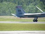
Iris F15 104th Fighter Wing Textures
(Category: FSX > Payware)
6.73Mb (316 downloads)
This is a texture for the payware Iris F15 in 104th Fighter Wing from Barnes Air National Guard Base in Westfield, Massachusetts.
Posted Jun 29, 2012 12:52 by MrAir4orce

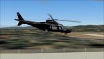
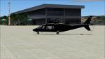
YV 1110CP A109 Helicopteros Pacheco textures
(Category: FS2004 > Helicopters)
1.06Mb (454 downloads)
YV 1110CP A109 Helicopteros Pacheco textures for the model from Alan Devins. Textures by Jose Armando Yanez YV-REPAINT'S FS2004
Required files:
required file
Posted Jun 29, 2012 12:33 by Jose Armando Yanez
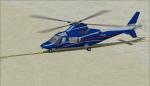
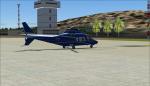
Agusta A-109 YV 274T Textures
(Category: FS2004 > Helicopters)
1.18Mb (555 downloads)
YV 274T textures for the A109 model by Alan Devins. By Jose Armando Yanez YV-REPAINT'S FS2004
Required files:
required file
Posted Jun 29, 2012 12:16 by Jose Armando Yanez
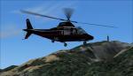
Agusta A-109 YV 257T Helicopteros Pacheco Textures
(Category: FS2004 > Helicopters)
1.04Mb (326 downloads)
Fs2004, A-109 YV 257T Helicopteros Pacheco textures for the A109 by Alan Devin. Textures by Jose Armando Yanez
Required files:
required file
Posted Jun 29, 2012 11:50 by Jose Armando Yanez