


All Files > Page 1905
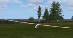
Rans S-12
(Category: FS2004 > Gliders and Ultralites)
23.46Mb (4288 downloads)
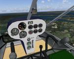
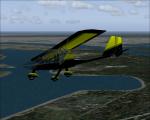
After I looked all over the net to find the perfect LSA for FS I decided that I was gonna need to make one of my own, one that represents the real world, low and slow flying. The Rans S12 is a gorgeous aircraft, with excellent view from the cockpit, but because of the massive wing and tail surfaces, she does handle like a ultralight.With are over a thousand sold and god knows how many flying the S12 is a
very successful aircraft. To bring more realism to the model, I recalibrated the gauges and made a pair of Becker comm and XPDR, it has both VC an 2D panels but I never used the 2D for anything. The Sound
Package if from Diego Furlan, (give the man the credit he deserves!!!) It's a two stoke sound but because of the high revs of the 912 the 2T is a lot closer to the real thing then the
lycommings'.By Ralph Wishart
Posted Aug 30, 2011 07:21 by Ralph Wishart


Rans S-12 Package
(Category: FS2004 > Props)
23.46Mb (2225 downloads)
After I looked all over the net to find the perfect LSA for FS I decided that I was gonna need to make one of my own, one that represents the real world, low and slow flying. The Rans S12 is a gorgeous aircraft, with excellent view from the cockpit, but because of the massive wing and tail surfaces, she does handle like a ultralight.With are over a thousand sold and god knows how many flying the S12 is a
very successful aircraft. To bring more realism to the model, I recalibrated the gauges and made a pair of Becker comm and XPDR, it has both VC an 2D panels but I never used the 2D for anything. The Sound
Package if from Diego Furlan, (give the man the credit he deserves!!!) It's a two stoke sound but because of the high revs of the 912 the 2T is a lot closer to the real thing then the lycommings'
Posted Aug 30, 2011 07:06 by Ralph Wishart

Boeing 707 Sabena Textures
(Category: FSX > Civil Jets)
7.42Mb (1041 downloads)
Boeing 707-323 Sabena Textures only. Requires B707V09.zip [Boeing 707 Collection - Version 2009 - for FSX and FS9].
By Guzman Artes -Libardo Guzman-
Required files:
required file
Posted Aug 29, 2011 18:51 by libardo guzman
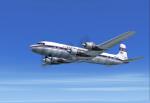
Aerovias Sud Americana DC-7 Textures
(Category: FSX > Vintage)
6.29Mb (389 downloads)
Aerovias Sud Americana textures for the FS2002, FS9, and FSX DC-7 aircraft by Greg Pepper and Tom Gibson (also available at Calclassic.com.)
Textures by Gary Harper.
Required files:
required file
Posted Aug 29, 2011 18:10 by Gary Harper

A380 Real Cockpit Radio Stack fix
(Category: FSX > Civil Jets)
0.00Mb (4370 downloads)
A380 Real Cockpit Radio Stack fix. Fixes the VC so now the radios panel is available. Also includes a sound file for those who got the no sound version.
Required files:
required file
Posted Aug 29, 2011 13:58 by admin

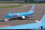
Luxair, Arkefly and Norwegian Texture Pack for FSX Default Boeing 737-800
(Category: FSX > Civil Jets)
9.73Mb (3086 downloads)
These are textures for the FSX Default Boeing 737-800. There are three textures; Luxair, Arkefly, and Norwegian Airlines. Each texture is as accurate to the real thing as I could get them. Come with Readme for installation.
Posted Aug 29, 2011 13:02 by Benjamin Bookman
FS2002 Default Boeing 747-400 Replacement Textures Figuring Typical Passenger and Cargo Airlines Worldwide
(Category: FS2002 > Civil Jets)
4.19Mb (1149 downloads)
FS2002 Default Boeing 747-400 Replacement Textures Figuring Typical Passenger and Cargo Airlines Worldwide. Need Some Text Editing. With a French Readme Too. by G. Guichard
Posted Aug 29, 2011 12:14 by G. Guichard
FS2002 Default Boeing 777-300 Replacement Textures Figuring Two Typical Passenger Airlines Worldwide
(Category: FS2002 > Civil Jets)
0.73Mb (696 downloads)
FS2002 Default Boeing 777-300 Replacement Textures Figuring Two Typical Passenger Airlines Worldwide. Need Some
Text Editing. With French Text Too. Freeware. by G. Guichard
Posted Aug 29, 2011 12:08 by G. Guichard
FS2004 SZD 30 Pirat Glider
(Category: FS2004 > Gliders and Ultralites)
0.64Mb (982 downloads)
FS2004 SZD 30 Pirat Glider
Manufactured in Poland, popular Polish Club Class sailplane
The HA-4379 served the Hungarian Posta Aero Club
FS2K Designed by Oscar Pedrosa, gauges by Wolfgang Piper
Mods for FS2K4 works by George Csillag
Posted Aug 29, 2011 11:56 by George Csillag

FS2002 Monaco Scenery
(Category: FS2002 > Scenery)
0.65Mb (1056 downloads)
Monaco Scenery for FS2002, With A French Readme Also
Posted Aug 29, 2011 11:54 by G. Guichard