


All Files > Page 1923
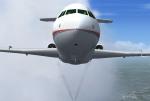
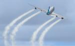
FSX/FS2004 BAC 1-11-200 with Hush Kits Engine smoke coordinates
(Category: FSX > Civil Jets)
0.06Mb (704 downloads)
FSX BAC 1-11-200 with hush kits engine smoke coordinates for the
freeware FS2004 BAC 1-11-200 with hush kits by David Maltby,
which you must have previously installed in FSX, and which
is available at (www.dmflightsim.co.uk) Easy installation.
By Tom Tiedman
Posted Aug 1, 2011 03:02 by Tom Tiedman
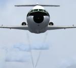
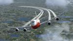
BAC 1-11-200 Engine Smoke Coordinates
(Category: FSX > Civil Jets)
0.04Mb (550 downloads)
FSX BAC 1-11-200 engine smoke coordinates for the freeware
FS2004 BAC 1-11-200 by David Maltby, which you must have
previously installed in FSX, and which is available at
(www.dmflightsim.co.uk) Easy installation. By Tom Tiedman
Posted Aug 1, 2011 03:00 by Tom Tiedman
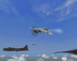
ETO BOE 1941-1945 Mission set HH 300
(Category: CFS3 > Missions & Campaigns)
0.07Mb (581 downloads)
These Missions are meant to challenge the flier and your ability to fly against heavy odds..
There are missions set in 1941-45' various types of missions, several "Furballs" where you fight hard just to survive.
Including, several Italian Missions for the RA..And some Me 262 missions set in 1945..
A package that requires Two downloads, Links included.
Thanks to The ETO/PTO Team for this wonderful expansion
And to Regs Hanger, and to Italian Wings/isoliti4gatti..
Posted Jul 31, 2011 23:25 by HouseHobbit
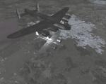
ETO TOW Night Fighter Missions 1943-1944 HH 200
(Category: CFS3 > Missions & Campaigns)
0.53Mb (660 downloads)
You Must fly from a flight plan, Beacon to Beacon..
Fly By instrument and comp headings in the briefings ** the mission plans
One base mission by O1-Driver
( Nine Hobbit missions with way points and without way points)
** Mosquito NF, Ju 88 NF, Me 110 NF and Do 217 NF aircraft**
And missions with way points for those who would like them to practice with
Based on methods that used by the Luftwaffe and Allies during the war..
Thanks to O1-Driver and Nachtpiloten
And to the ETO/PTO Team Many Thanks for the Great ETO Expansion Sim
Posted Jul 31, 2011 23:22 by HouseHobbit
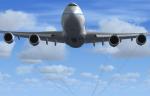
FSX 747-8F Freighter Engine Smoke or White Airshow Smoke Coordinates
(Category: FSX > Civil Jets)
0.49Mb (1846 downloads)
FSX Boeing 747-8F freighter gray engine smoke effect (or white
airshow engine smoke effect so you can wow them at Oshkosh)
for the freeware Project Opensky 747-8F when used in FSX.
Requires previous installation in FSX of a Posky 747-8F,
such as the N5017Q model in rollout colors shown in
these screenshots (newposky748fwvc.zip). Easy installation.
By Tom Tiedman
Required files:
required file
Posted Jul 31, 2011 23:22 by Tom Tiedman
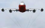
FSX 747-8i Engine Smoke or White Airshow Smoke Coordinates
(Category: FSX > Civil Jets)
0.24Mb (2341 downloads)
FSX Boeing 747-8i passenger model gray engine smoke effect
(or white airshow engine smoke effect so you can wow them at
Oshkosh) for the freeware SkySpirit2011 747-8i when used in FSX.
Requires previous installation in FSX of a SkySpirit2011 747-8i,
such as the N6067E model in rollout colors shown in
these screenshots (ssp748v4_genx_n6067e.zip). Easy installation.
By Tom Tiedman
Required files:
required file
Posted Jul 31, 2011 22:26 by Tom Tiedman
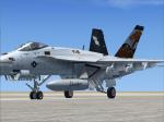
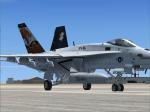
VRS Superbug VFA-86 CAG Textures
(Category: FSX > Payware)
2.69Mb (684 downloads)
VRS Superbug VFA-86 Sidewinders CAG
textures only. Requires the payware VRS SuperBug. Repaint by Hornet202 Enjoy
Posted Jul 31, 2011 21:57 by Chris Hammons
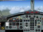
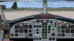
British Aerospace BAC 1-11 2D Panel (Standard screen)
(Category: FSX > Panels)
2.25Mb (1507 downloads)
Photorealistic 2D panel (4/3 screen) for the British Arerospace BAC 1-11. You can use this panel with the FS9 model by David Maltby. All custom gauges in xml for FSX compatibility. See instructions for installation and configuration in the readme.txt file.
Required files:
required file
Posted Jul 31, 2011 13:12 by Philippe Wallaert
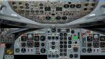
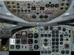
British Aerospace BAC 1-11 2D panel (Wide screen)
(Category: FSX > Panels)
2.08Mb (1156 downloads)
Photorealistic 2D panel (16/9 screen) for the British Arerospace BAC 1-11. You can use this panel with the FS9 model by David Maltby. All custom gauges in xml for FSX compatibility. See instructions for installation and configuration in the readme.txt file.
Required files:
required file
Posted Jul 31, 2011 03:04 by Philippe Wallaert
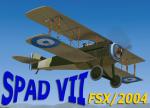
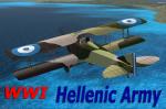
FSX/2004 SPAD VII Hellenic Army Package
(Category: FSX > Vintage)
8.30Mb (2868 downloads)
FSX /2004 Hellenic Army Air Sevice (STRATIOTIKH AEROPIKH YPHRESIA)Spad VII Package.
The SPAD S.VII was in action during WWI with 16 aircraft of the Hellenic Army Air Service operating
with the Greek/ French Sqadrons and during the Asia Minor Campain as a Fighter.
This is a complete package with full VC and 2d panel and gages, effects and Sound.
Many thanks to Stuart Green for this outstanding freeware model.Repaint for the Hellenic colors and repacking for FSX by Yiannis Katehis Tsetsas.
Posted Jul 30, 2011 22:38 by YIANNIS KATEHIS TSETSAS