


All Files > Page 2181
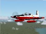
IRIS T-6A Texan II - FS9 - RAF T-6 Linton Red and White Textures
(Category: FS2004 > Payware)
3.92Mb (439 downloads)
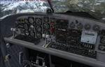
IRIS T-6A Texan II - FS9 - RAF T-6 Linton Red and White
Texure coulours are based on RAF Tucano at Linton On Ouse UK Code EGXU Web www.raf.moduk/raflintononouse
This repaint requires the payware IRIS T-6A Texan II.
Repaint by Dave Gore fooflyer
Posted Sep 3, 2010 20:50 by Dave Gore fooflyer
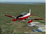
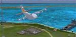
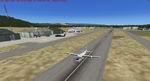
Monterey Peninsula Airport KMRY Version 2
(Category: FSX > Scenery)
11.36Mb (2777 downloads)
Scenery for Monterey Peninsula Airport Version 2, located on the coast in Central California. The Monterey Peninsula Airport has regular flights that are available to San Francisco, Los Angeles, Phoenix, Denver and Las Vegas where connecting flights can take you anywhere in the world. There are five fixed base operators located here: APR Aviation, Million Air, Monterey Bay Aviation, Monterey Jet Center and Navy Flying Club. Version 2 adds the following: Photoscenery to cover within airport grounds, all aprons, taxiways, buildings placed correctly on phototexture, GA Static aircraft, apron lights, taxi lights, animated windsock with segmented circle and pattern markers and a variety of custom hangars and eye-candy. See update below.
Posted Sep 3, 2010 17:38 by Eric McCloud
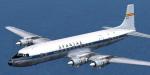
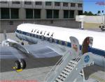
FS2004/FSX DC-7C SPANTAX Textures
(Category: FS2004 > Props)
6.89Mb (1172 downloads)
FS2004/FSX REPAINT ONLY DC-7C Seven Seas (CalClassic) - SPANTAX dark blue. Original Aircraft by Greg Pepper and Tom Gibson. Repainted by Enrique Medal.
Required files:
required file
Posted Sep 3, 2010 17:00 by Enrique Medal
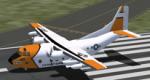
Operation Tight Reign for FSX Vietnam War project
(Category: FSX > Scenery)
71.26Mb (2286 downloads)
1966 - USAF ask US Coast Guard for help during flight navigation.
A USCG team was sent to South-East Asia to install four Loran C stations at Sattahip and Lampang (Thaîland), Con Son, and later Tan My (Vietnam). They were helped by a USCG C-123.
1975 - The day before Saigon fell the Loran Station on Con Son Island was evacuated. The final radio messages were:
To: Con Son
From COMSEASEC.
Destroy equipment. Evacuate aboard Air America chopper. When safely evacuated, advise COMSEASEC your location and names of personnel. Also equipment salvaged, if any.”
“This is Con Son. Roger. We will be going off air in five minutes and will destroy equipment. Will try to keep comms until the end.” (from Chuck Zanti, Con Son Loran-C history, pdf document)
Content : USCG Loran C stations during Vietnam war.
Con Son, Sattahip, Lampang airfields.
C-123 USCG AI and trafic files
C-123 USCG texture for V Zhyhulskiy C-123
French and english Documentations
require : FSX Vietnam War project base pack
and Vladimir Zhyhulskiy C-123
By Jacques Godfrin, Xavier Carre - FSX Vietnam War project http://vietnamwar.project.free.fr/
FSX Vietnam War Project :
find-file?fileId=6116
Posted Sep 3, 2010 13:45 by Jacques Godfrin, Xavier Carre
AFCAD Newcastle EGNT, UK
(Category: FSX > Scenery)
0.01Mb (803 downloads)
This is my 1st AFCAD file updating the original stock file of EGNT Newcastle UK.
Basically putting the correct gates and their numbers in place.
Just place the bgl file into your Microsoft Flight Simulator XAddon Sceneryscenery directory.
Posted Sep 3, 2010 09:00 by Paul Humphries
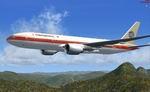
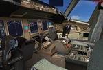
Continental Airlines Old Colors Boeing 777-200
(Category: FSX > Civil Jets)
61.37Mb (6792 downloads)
FSX Continental Airlines Boeing 777-200 (fictional old colors). Includes detailed virtual cockpit and inbuilt scenery. Model by Project Open Sky. Repaint by Jim Waters.
Posted Sep 3, 2010 07:24 by Jim Waters
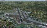
Orio al Serio (LIME), Bergamo, Italy
(Category: FSX > Scenery)
0.37Mb (2463 downloads)
FSX Orio al Serio (LIME), Bergamo, Italy. Refurbished to match the real world. All gates are present correct taxiway and lots of object. For FSX default scenery only. By Victor Nauta.
Posted Sep 3, 2010 06:18 by Victor Nauta
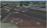
Kalispell City Airport, Montana
(Category: FSX > Scenery)
1.57Mb (814 downloads)
FSX Kalispell City Airport (S27) additions, Montana (MT). Includes two military style hangars, one new style hangar and a warehouse along with upgrades to the default airport adding taxiways and parking areas, many vehicles (ground vehicles and aircraft) and two start / landable helipads.
Posted Sep 3, 2010 06:17 by Nathan Blue
Blue Smoke Effect
(Category: FSX > Misc)
1.34Mb (1407 downloads)
Blue smoke effect for any plane.
Posted Sep 2, 2010 17:02 by Austin Sedivy(ams0596)
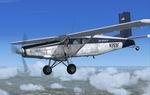
Pilatus PC-6C H2 Package
(Category: FSX > Props)
12.12Mb (61529 downloads)
FSX SP-2 Acceleration
Pilatus PC-6C_H2
Fairchild-built version of the Pilatus PC-6 Turbo Porter, with the Garrett TPE 331 turboprop engine. This release also includes a paint kit. By Tim 'Piglet'Conrad
Posted Sep 2, 2010 06:03 by Piglet