


All Files > Page 1417

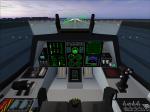
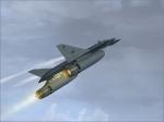
CF-220 Grizzly Package (v.4)
(Category: FSX > Military)
107.65Mb (6292 downloads)
CF-220 Grizzly (version 4, revised 2013) for FSX. Concept design for a Canadian dedicated air superiority aircraft with secondary ground attack capability. Features include full virtual cockpit, operating afterburner petals, four loadout options, and a total of 56 texture options (including four display schemes). FREEWARE by Brian Sturton.
Posted Aug 25, 2013 03:49 by Brian Sturton

CF-220 Grizzly Package (v.4)
(Category: FS2004 > Military)
79.32Mb (3317 downloads)
CF-220 Grizzly (version 4, revised 2013) for FS2004. Concept design for a Canadian dedicated air superiority aircraft with secondary ground attack capability. Features include full virtual cockpit, operating afterburner petals, four loadout options, and a total of 56 texture options (including four display schemes). FREEWARE by Brian Sturton.
Posted Aug 25, 2013 03:21 by Brian Sturton
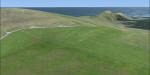
EGPB, Scotland, Photorealistic Scenery
(Category: FSX > Scenery)
31.01Mb (2074 downloads)
Photorealistic scenery for EGPB in Scotland. Sumburgh Airport is the main airport serving Shetland Island in the north of Scotland
Posted Aug 25, 2013 02:15 by sander
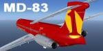
FS2004 & FSX MD-83 1time Airline Textures
(Category: FS2004 > Civil Jets)
1.59Mb (443 downloads)
FS2004 & FSX MD-83 1time Airline. Repaint for HJG's MD-83 model, downloadable at:
http://simviation.com//hjg/main.htm
Posted Aug 24, 2013 15:24 by Enrique Medal
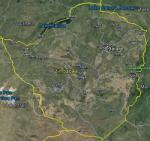
FSX Zimbabwe Airfield Locator
(Category: FS Navigation > Flight Simulator Navigation)
2.50Mb (90 downloads)
Tested on Windows XP and Windows 7.
This download adds airfield markers and ICAO id's found in FSX, and overlays them on Google Earth.
This file is for Zimbabwe .
There is also a seperate file with a list of basic airfield location details.
i.e: EGBB Birmingham Airport. Birmingham. N52* 27.23' W1* 44.88' alt325.
Also the tidying "My places" in Google Earth, file.
Other locator files to follow.
by Carl Vokes
Posted Aug 24, 2013 15:20 by carl vokes
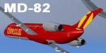
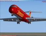
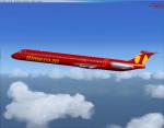
FS2004 & FSX MD-82 1time Airline Textures
(Category: FS2004 > Civil Jets)
1.46Mb (270 downloads)
FS2004 & FSX MD-82 1time Airline. Repaint for HJG's MD-82 model, downloadable at:
http://simviation.com//hjg/main.htm
Posted Aug 24, 2013 15:14 by Enrique Medal
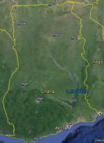
FSX Ghana Airfield Locator
(Category: FS Navigation > Flight Simulator Navigation)
2.43Mb (72 downloads)
Tested on Windows XP and Windows 7.
This download adds airfield markers and ICAO id's found in FSX, and overlays them on Google Earth.
This file is for Ghana.
There is also a seperate file with a list of basic airfield location details.
i.e: EGBB Birmingham Airport. Birmingham. N52* 27.23' W1* 44.88' alt325.
Also the tidying "My places" in Google Earth, file.
Other locator files to follow.
by Carl Vokes
Posted Aug 24, 2013 14:18 by carl vokes
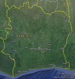
FSX Cote d'lvoire Airfield Locator
(Category: FS Navigation > Flight Simulator Navigation)
2.46Mb (62 downloads)
Tested on Windows XP and Windows 7.
This download adds airfield markers and ICAO id's found in FSX, and overlays them on Google Earth.
This file is for Cote d'lvoire .
There is also a seperate file with a list of basic airfield location details.
i.e: EGBB Birmingham Airport. Birmingham. N52* 27.23' W1* 44.88' alt325.
Also the tidying "My places" in Google Earth, file.
Other locator files to follow.
by Carl Vokes
Posted Aug 24, 2013 14:16 by carl vokes
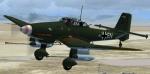
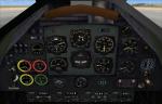
FSX VC panel update for the Alphasim Ju 87 Stuka
(Category: FSX > Panels)
3.96Mb (1111 downloads)
I reconfigured all the VC gauges according to Jean-Pierre Langer`s photorealistic 2d panel and added more gauges to it to make it look more complete. Thanks to Jean-Pierre,
whose great panel is part of this download.
Posted Aug 24, 2013 10:49 by Michael Pook
.jpg-thumb.jpg)
.jpg-thumb.jpg)
Texture fix for the He-112b VC
(Category: FSX > Panels)
0.08Mb (284 downloads)
This is a texture fix for the He-112b,which
forgot to enclose in my recent upload of the
He-112b VC. Sorry!
Required files:
required file
Posted Aug 24, 2013 05:42 by Michael Pook