


All Files > Page 1646
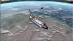
STS-51L Alternate History Scenarios
(Category: Space Orbiter > Orbiter Addons)
0.01Mb (2013 downloads)
This is my tribute package for the last flight of Challenger; STS-51L. Based upon historical documentation and personal development of orbital state vectors for the expected flight events I have created the following scenarios using the available components from the "STS_Payloads" package and my previously release extension package for the Shuttle Fleet.
Godspeed to Challenger and her crew; let this package be a celebration of their dream.
Space Orbiter base pack here
Posted Aug 2, 2012 21:15 by David413
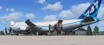
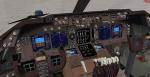
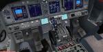
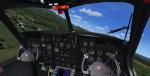
Boeing 747-8F Cargo Rollout Colors with Enhanced VC
(Category: FSX > Civil Jets)
48.19Mb (4082 downloads)
Project Opensky - Boeing 747-8F CARGO ROLLOUT COLOR NEW VC
747-8GEnx Enhanced VC for FSX
Skyspirit FSX native Boeing 747-800 Freighter model upgraded using the vastly improved Boeing 747 VC from Alejandro Rojas Lucena/FSND (See panel docs for details). VC includes FMC, EICAS, MFD with control panel, GPWS, working wipers, cabin lights, fire suppression, avionics switch, fuel crossfeed, landing lights switches, taxi light switch, engine generators, APU generator, battery switch, starter switches, de-ice switch, general lights switches. Beautiful Skyspirit 747-800 Freighter model with complex features and ground service vehicles (press shift e 2, shift e 3, etc. ). Textures by Project Opensky member.
Also includes Boeing 747 VC textures upgrade by Jason A. Lee. This give a much clearer 747 interior look.
Assembled and edited for FSX by Chris Evans.
Zip preview for larger pictures.
See panel docs and images for VC details and controls!
Posted Aug 2, 2012 11:42 by chris evans
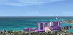
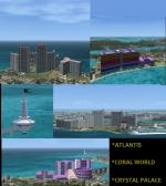
Nassau Bahamas Landmarks
(Category: FSX > Scenery)
1.59Mb (3602 downloads)
This scenery of Nassau/Paradise Island. Bahamas has 3 major landmarks that include Atlantis Resort & Casino, Coral World (underwater observatory)and Carnival's Crystal Palace Resort & Casino. Created by bahamasflyers
Posted Aug 1, 2012 23:53 by SHAWN PENN
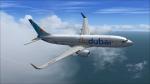
Fly Dubai - Boeing 737-8KN(WL) with VC
(Category: FSX > Civil Jets)
22.29Mb (3632 downloads)
Project Open Sky - Flydubai Boeing 737-8KN(WL). Includes the enhanced VC from Alejandro Rojas Lucena/FSND with GWPS and FMC, for FSX.
Posted Aug 1, 2012 19:43 by Joel Stern
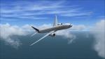
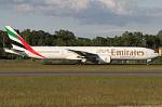
Boeing 777-31H(ER) -- Emirates (A6-EGL)
(Category: FSX > Civil Jets)
77.06Mb (5466 downloads)
Project Open Sky -- Emirates Boeing 777-31H(ER) - 41072 / 985 [V2] for FSX with working gauges.
Posted Aug 1, 2012 19:09 by Joel Stern
Boeing 717 Soundset
(Category: FS Sounds > Flight Simulator Sounds)
1.92Mb (1155 downloads)
A Boeing 717 Soundset with sounds from JT8D and V2500. even though these sounds are from different engines it still sounds like a BR715! For the A1-30 series ONLY. C1-30 series coming soon!
Posted Aug 1, 2012 18:20 by LM Aviation
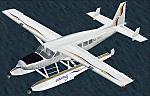
FS2002/2004 Seawings Cessna 208 Caravan Amphibian Repaints
(Category: FS2002 > Props)
13.33Mb (1198 downloads)
Two complete textures for the FS2002 default Caravan Amphibian, based on the livery of real-world airline Seawings, which operates three C208s. These are complete MIP-mapped reflective DXT3 textures including DXT1 damage textures. Variations are 'Polar' (with de-icing boots) and 'Tropical' (without de-icing boots). Also included: paint kit (blank) textures and alpha channel reflection and transparency files, as well as a voice mod file for EditVoicepack.
Tested in FS2002 only but should also work in FS2004.
Posted Aug 1, 2012 17:17 by A.J. Franzman
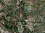
FSX Colorado Airfield Locator
(Category: FS Navigation > Flight Simulator Navigation)
2.76Mb (146 downloads)
Tested on Windows XP and Windows 7.
This download adds airfield markers and ICAO id's found in FSX, and overlays them on Google Earth.
This file is for Colorado. USA
There is also a seperate file with a list of basic airfield location details.
i.e: EGBB Birmingham Airport. Birmingham. N52* 27.23' W1* 44.88' alt325.
Also the tidying "My places" in Google Earth, file.
Other locator files to follow.
by Carl Vokes
Posted Aug 1, 2012 14:50 by carl vokes
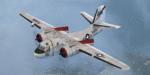
Grumman S2F-3 Tracker Sound Patch
(Category: FSX > Military)
36.02Mb (4568 downloads)
This is a patch for existing users of the FSX Grumman S2F-3 Tracker. Just run the installer in this download to add the missing sound folder to the original release.
Posted Aug 1, 2012 13:15 by Milton Shupe, George Arana, Brandon Filer, Sim-Outhouse
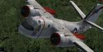
Grumman S2F-3 Tracker FSX Package
(Category: FSX > Military)
42.36Mb (17967 downloads)
Functional VC model included; Package includes one aircraft with two beautifully crafted exterior liveries, a great flight model, authentic custom radial sounds, and custom panels with aircraft specific gauges, and easy-to-read clickable virtual cockpits.
FSX native upgrade by Eagle Rotorcraft Simulations
This aircraft release is one of 7 aircraft in a series that will be released.
FSX Only. DirectX 10 compatible.
Posted Aug 1, 2012 02:23 by Milton Shupe, George Arana, Brandon Filer, Sim-Outhouse