


All Files > Page 1652
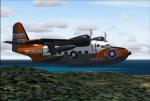
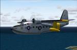
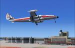
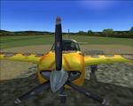
Grumman Albatross (short winged) UF-1/HU-16 Package
(Category: FS2004 > Props)
89.10Mb (3929 downloads)
FS2004 Grumman Albatross (short winged) UF-1/HU-16.The Albatross
started out as a company venture in the late forties and became such a success
that it has been used by more than two dozen armed forces throughout the
world.Original by Greg Pepper,and Michael Verlin.
Models by "Swingman",sounds by "Skysong Soundworks",and textures
by Michael Verlin. Some texture mods by James Craig. 4 different
models, 2d panel as well as VC, unique sounds, many textures, etc..
Posted Jul 24, 2012 06:09 by uploader
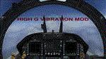
FSX Virtual Cockpit High G Vibration Mod for Fighter Jets
(Category: FSX > Misc)
2.74Mb (1669 downloads)
This mod adds to your Default Acceleration F/A-18C Hornet, High G Vibration effects and sounds in virtual cockpit.
You can Add this mod to other jets too.
Posted Jul 23, 2012 17:27 by Ismail Hakki Guezel
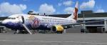
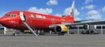
Boeing 737-800w Tuifly (Bären Marke-cs) Package
(Category: FSX > Civil Jets)
21.20Mb (1479 downloads)
Project Opensky Boeing 737-800w Tuifly (Bären Marke-cs)
for Microsoft Flight Simulator X
Skyspirit/Project Opensky native FSX Boeing 737-800 model.
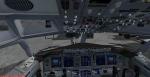
Upgraded to FSX using the Alejandro Rojas Lucena/FSND revised Boeing 737-800 VC. This model includes Working wipers (right mouse click on switch) with rain effect. Switches for LCD Screens, EICAS, PFD, MFT. Autobrake switch. Opening pilots window. Cabin Lights switch. Realistic FMC. Ground Proximity Warning System (GPWS), More Realistic night textures. FSX native model winglet by Skyspirit/Project Opensky. VC by MS/Alejandro Rojas Lucena/FSND. Textures by Mathieu Vos. Modified for FSX by Chris Evans.
Posted Jul 23, 2012 15:10 by Chris Evans
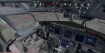
Boeing 737-800w Tuifly (Cewe Fotobuch-cs) Package
(Category: FSX > Civil Jets)
19.54Mb (3440 downloads)
Project Opensky Boeing 737-800w Tuifly (Cewe Fotobuch-cs)
for Microsoft Flight Simulator X
Skyspirit/Project Opensky native FSX Boeing 737-800 model.
Upgraded to FSX using the Alejandro Rojas Lucena/FSND revised Boeing 737-800 VC. This model includes Working wipers (right mouse click on switch) with rain effect. Switches for LCD Screens, EICAS, PFD, MFT. Autobrake switch. Opening pilots window. Cabin Lights switch. Realistic FMC. Ground Proximity Warning System (GPWS), More Realistic night textures.
FSX native model winglet by Skyspirit/Project Opensky. VC by MS/Alejandro Rojas Lucena/FSND.
Textures by Mathieu Vos.
Modified for FSX by Chris Evans.
Posted Jul 23, 2012 15:01 by Chris Evans
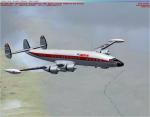
FSX/FS2004 Lockheed L-1049E Constellation IberiaTextures
(Category: FS2004 > Props)
4.05Mb (1075 downloads)
This repaint was one of ten IBERIA's units of Super Constellation: EC-AIN. "Santa Maria" 1049 E-55 (Serial number S/N 4550). A repaint of Manfred Jahn's outstanding Lockheed L-1049 Super G Constellation.
Required files:
required file
Posted Jul 23, 2012 02:51 by Enrique Medal
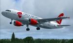
Airbus A319 Czech Airlines
(Category: FSX > Civil Jets)
63.68Mb (3267 downloads)
Project Airbus Czech Airlines A319 OK-PET for FSX.
Includes default VC, upgraded by Jim Fly.
You can find this aircraft under 'Project Airbus' in your FSX menu.
Posted Jul 23, 2012 02:23 by Jim Fly
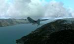
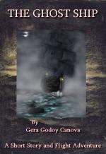
Ghost Ship of the Southern Seas
(Category: FSX > Missions)
0.94Mb (3705 downloads)
This is not a "Mission", its a story of an expedition is South Chile and you will be in the middle of it together with Max Rex, Dr. Buenas and a beautiful lady..." " Santiago tower this is CP559 about twenty miles from your station to land" Max shut the microfone and waited through the radio static a responce. After a few seconds a noice crackling voice said " CP559, land as you see fit, there is a large thunderstorm over the city but two planes just landed without much problema, be on the lookout for lighting"..So the story starts!!!!....
Posted Jul 23, 2012 02:15 by Gera Godoy Canova
Spike's Landing And Taxi Light Gauge
(Category: FS Gauges > FS Gauges)
0.23Mb (472 downloads)
Tired of fiddling with landing light switches on approach?? Use both landing and taxi lights when landing a small aircraft?? Then here’s a handy gauge for you! Add this to any aircraft and when you toggle the landing lights the taxi will also come on for more lighting power. Once on the ground turn off your landing lights off again and the taxi lights stay on (until you turn them off) making lighting control easy.
I made this gauge work only when the aircraft is airborne thus still allowing full lighting control on the ground.
Posted Jul 23, 2012 02:01 by Spike
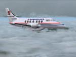
Virtualcol PAWA Dominicana British Aerospace Jetstream 31 (HI841) Textures
(Category: FS2004 > Payware)
1.07Mb (224 downloads)
British Aerospace Jetstream 31,(cn 674), registration HI841, wearing the last
colors used by PAWA in its Jetstream 31. Fully reworked textures only for the
Virtualcol BAe Jetstream 31 model (payware package). Look at
http://products.virtualcol.com/ for detailed info. By Juan Ernesto Oropeza.
Posted Jul 23, 2012 01:58 by Juan Ernesto Oropeza
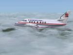
Virtualcol PAWA Dominicana British Aerospace Jetstream 31 (HI817) Textures
(Category: FS2004 > Payware)
1.28Mb (174 downloads)
British Aerospace Jetstream 31,(cn 673), registration HI817, wearing the last colors used by PAWA in its Jetstream 31. Fully reworked textures only for the
Virtualcol BAe Jetstream 31 model (payware package). Look at http://products.virtualcol.com/ for detailed info. By Juan Ernesto Oropeza.
Posted Jul 23, 2012 01:56 by Juan Ernesto Oropeza