


All Files > Page 1657
FSX - Blue User Interface replacement
(Category: FSX > Misc)
1.80Mb (3022 downloads)
Graphics replacement for FSX UI (user interface). See readme for further information.(as always back up any files before replacing)
Posted Jul 14, 2012 12:17 by Jiri Soukup
JT8D Soundpack
(Category: FS Sounds > Flight Simulator Sounds)
64.33Mb (5486 downloads)
Finally, there's a JT8D soundpack with sonecones! This is a must for any pilot of an aircraft powered by the JT8Ds. Enjoy!
Posted Jul 14, 2012 00:14 by Brandon G.

FS2004/FSX United Short Range Traffic with complete sound
(Category: FSX > Scenery)
9.58Mb (1613 downloads)
FS2004/FSX United Short Range Traffic with complete sound
Posted Jul 13, 2012 18:53 by Edriann Nazareth

Boeing 737-200 Southern Winds
(Category: FS2004 > Civil Jets)
7.49Mb (2245 downloads)
Boeing 737-200 in "Southern Winds" Argentine airline colours. Model By Erick Cantu /Kittyhawk. Complete aircraft includes panel & sound, full animated parts, opening passengers and cargo doors and much more. This update contains operating Taxi lights and splashlights on wings.
Posted Jul 13, 2012 18:44 by LUIS CASTRO
SkySpirit Boeing 747-8i Garuda Indonesia Textures
(Category: FSX > Civil Jets)
17.29Mb (3680 downloads)
i've updated Febrianto Leocesio's Garuda Indonesia texture for the FS2004 SkySpirit 748i to be usable in the FSX version of the SkySpirit 748i. Currently Garuda doesn't have any plan of buying the 747-8i, instead it has chosen to buy the 777-300er instead. For the base file search for 747-8 in simviation, and download the "skyspirit 747-8i 2012 collection"
Required files:
required file
Posted Jul 13, 2012 16:38 by ryanID
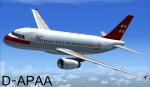
Airbus A319 Privat Air Package
(Category: FSX > Civil Jets)
35.84Mb (2038 downloads)
Project Airbus A319 Privat Air D-APAA for FSX.
Includes default VC, upgraded by Jim Fly.
You can find this aircraft under 'Project Airbus' in your FSX menu
Posted Jul 13, 2012 06:00 by Jim Fly
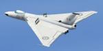
Avro Vulcan B.1 VX770 Beta Version (visual model only)
(Category: FSX > Military)
12.86Mb (2926 downloads)
Avro Vulcan B.1 VX770. Visual model only (no panel - just with the default 737 panel). Default sounds. No VC. Slightly updated from the original Doug Sleigh version. Source file included (FSDS FSC file) in case anyone wished to develop this model.
Posted Jul 13, 2012 04:51 by Jarod Edwards
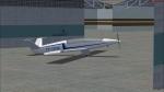
Cessna 150 DQWWT Textures
(Category: FS2004 > Props)
2.48Mb (152 downloads)
This is a Cessna 150 aircraft that I painted into the color of my Flying school (Advance Aviation Training Fiji Ltd)aircraft DQ-WWT. Requires the Ranchojen C150
Required files:
required file
Posted Jul 13, 2012 00:21 by Haueia Joseph Reemon
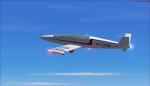
Fs2004/Fs2002 Moni Motorglider YV-09X
(Category: FS2004 > Gliders and Ultralites)
3.58Mb (1749 downloads)
This is the FS2002/FS2004 Moni Motorglider by Monnett Experimental Aircraft Company. This model features an opening canopy, detailed Virtual Cockpit with functioning instruments, FS2002 Panel adaption folder, animated control surfaces, working suspension, turning pilots head, and a 3d panel. Original modeled in Gmax by William Ortis. Texture by Armando Yanez YV-REPAINT'S
Posted Jul 12, 2012 23:24 by Jose Armando Yanez
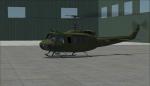
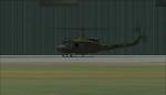
UH-1H Ejercito Venezolano EV-7704 textures
(Category: FS2004 > Helicopters)
1.04Mb (515 downloads)
EV-7704(Ejercito Venezolano) textures for the model by Jordan Moore. Texture By Jose Armando Yanez YV-REPAINT'S FS2004
Required files:
required file
Posted Jul 12, 2012 22:39 by Jose Armando Yanez