


All Files > Page 1693
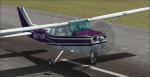
Cessna 172 N971JR Textures
(Category: FSX > Props)
5.84Mb (401 downloads)
Textures only for the default Cessna 172 in the fictional N971JR. It is a purple Cessna 172 with some black. The livery and the tail number are fictional. There are instructions on how to install in the readme file. By Tyler Lawrence.
Posted May 25, 2012 18:36 by Tyler Lawrence
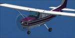
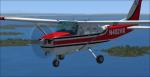
Cessna 172 N4179H Textures
(Category: FSX > Props)
5.45Mb (464 downloads)
Textures only for the default Cessna 172 in the fictional N4179H. It is a maroon Cessna 172 with some black. The livery and the tail number are fictional. There are instructions on how to install in the readme file. By Tyler Lawrence.
Posted May 25, 2012 18:31 by Tyler Lawrence
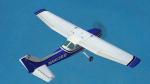
Cessna 172 N903ED Textures
(Category: FSX > Props)
5.72Mb (539 downloads)
Textures only for the default Cessna 172 in the fictional N903ED. It is a blue Cessna 172 with some black. The livery and the tail number are fictional. There are instructions on how to install in the readme file. By Tyler Lawrence.
Posted May 25, 2012 18:22 by Tyler Lawrence
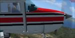
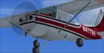
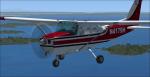
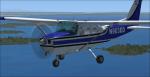
Cessna 172 N492VR Textures
(Category: FSX > Props)
5.73Mb (494 downloads)
Textures only for the default Cessna 172 in the fictional N492VR. It is a red Cessna 172 with some black. The livery and the tail number are fictional. There are instructions on how to install in the readme file. By Tyler Lawrence.
Posted May 25, 2012 18:15 by Tyler Lawrence
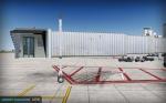
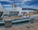
FSX Jetways New Textures
(Category: FSX > Scenery)
21.01Mb (10915 downloads)
These Jetways replace the old boring jetways in FSX. This file contains two jetway textures. Real life jetway textures and a creative jetway texture. (Be sure to back up your original files in case you decide to go back)
Posted May 25, 2012 12:06 by Jack Doss

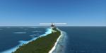
FSX Northern Cook Islands Photo Real Scenery
(Category: FSX > Scenery)
161.12Mb (4125 downloads)
The Northern Cook Islands are a group of 6 islands and atolls in the South Pacific Ocean, north east of New Zealand. The Northern Cookies in this package are: Manihiki, Nassau, Penrhyn, Pukapuka, Rakahanga and Suwarrow. Texture resolution 1m/pixel. By Tiberius Kowalski
Posted May 25, 2012 08:08 by Tiberius Kowalski
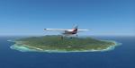
FSX Southern Cook Islands Photo Real Scenery
(Category: FSX > Scenery)
98.35Mb (2816 downloads)
The Southern Cook Islands are a group of 9 islands and atolls in the South Pacific Ocean, north east of New Zealand. The Southern Cookies in this package are: Aitutaki, Atiu, Mangaia, Manuae, Mauke, Mitiaro, Palmerston, Rarotonga and Takutea.
Texture resolution 1m/pixel. By Tiberius Kowalski
Posted May 25, 2012 07:17 by Tiberius Kowalski
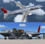
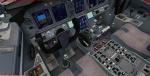
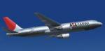
JAL CARGO Silver Bullet Boeing 767-300ER Package
(Category: FSX > Civil Jets)
29.94Mb (4350 downloads)
JAL CARGO Silver Bullet Boeing 767-300ER JA631J
Upgraded to FSX using Alrot's revised Boeing 737-800 VC. This model includes Working
wipers (right mouse click on switch) with rain effect. Switches for LCD Screens, EICAS,
PFD, MFT. Autobrake switch. Opening pilots window. Cabin Lights switch. Realistic FMC.
Ground Proximity Warning System (GPWS), More Realistic night textures. Model features
High resolution textures, Dynamic flexing wings, Body gear steering, Nose gear
steering, Rudder lock, Ground spoilers, Low speed aileron locks at high speed, Fully
animated control surfaces, Fully independent suspension, Trim Animation, Opening
Passenger Doors, Animated tilting bogies, Rolling wheels, Animated thrust reverser's
with reverser block doors, Detailed textures, Full night lighting, Crash affects,
Ground Service Vehicles (Activate under Views-Instrument panel - Posky Utilities)..
Model Designer Hiroshi Igami/Yosuke Ube. Flight Dynamics Designer Warren C. Daniel.
Painted by Yosuke Ube.
FSX native model by Skyspirit. VC by Alejandro Rojas Lucena (Alrot).
Modified for FSX by Chris Evans.
Posted May 25, 2012 06:58 by Chris Evans
Boeing 767-300ER JAL Cargo Silver Bullet
(Category: FS2004 > Civil Jets)
15.61Mb (1190 downloads)
SKYSPIRIT2010 BOEING 767-300F v5 for FS2004
JAL Cargo Silver Bullet Boeing 767-300ER JA631J.
Painted by Yosuke Ube. Thank you to the Skyspirit team, for their wonderful models!
Posted May 25, 2012 06:21 by Chris Evans
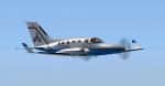
VFR Prop Hops Cessna 414A Package
(Category: FSX > Props)
12.90Mb (8276 downloads)
The complete Cessna 414A Chancellor package from Premier Aircraft Design plus the VFR Prop Hops livery.
We fly general aviation aircraft in group flights and special events on the VAT ME Server - http://www.vatmegroup.com/newsite/ See our website at www.vfrprophops.com - contact us at vfrprophops@gmail.com. We want all pilots who want to do real general aviation simulation. We follow FAA rules for VFR flight but we also use ILS approaches and other instrument flying. Flight plans are available in our personal TeamSpeak channel - sign up with us at www.vfrprophops.com for more information.
Posted May 24, 2012 16:32 by VFR Prop Hops