


All Files > Page 1927
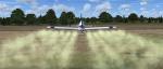
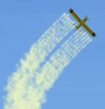
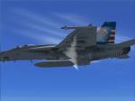
FSX Air Tractor 802A Crop Duster Chemical Trails Fix
(Category: FSX > Props)
0.69Mb (4488 downloads)
By request, an FSX Air Tractor 802A Crop Duster chemical trails fix
for the wonderful freeware Brian Gladden FS9 Air Tractor 802A
Crop Duster version when used in FSX, which you must have previously
installed in FSX. Changes the nozzle count from 7 per wing to 6 for a
more well defined and visually appealing space between chem-trails.
Fixes the missing chem-trail in Brian's original release. Offers your
choice of four [SMOKESYSTEM] chem-trail coordinates... for FS9 white
smoke, FSX white smoke, FSX red smoke, or FSX thin gray smoke.
Includes a blue and white repaint texture. Easy installation.
By Tom Tiedman
Required files:
required file
Posted Jul 28, 2011 21:10 by Tom Tiedman
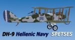
FSX DeHavilland DH-9 Hellenic Royal Navy SPETSES Package
(Category: FSX > Vintage)
4.23Mb (1414 downloads)
FSX Hellenic Royal Navy Air Service (NAYTIKH AEROPORIKH YPHRESIA) DeHavilland DH-9
This is a complete package with full VC and 2d panel and gauges.
N.A.Y.received, after the end of WWI, a total of 42 D.H.9s and used them as rec/bombers.After 1926 six of them were transformed in to Hydroplanes (Coming Soon in Another repaint). The D.H.9s were used with success by N.A.Y. during the Micrasiatic Campaign (1922). All the D.H.9s were based on Tatoi's and Faliro's Airports, near Athens, until 1932. Original Model by Chris Herring whom i thank for giving me the permition to include the model in this package. Repaint for the Hellenic colors and repacking for FSX by Yiannis Katehis Tsetsas.
Posted Jul 28, 2011 17:17 by YIANNIS KATEHIS TSETSAS
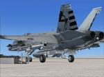
VRS Superbug VX-23 Salty Dogs Line 2 Textures
(Category: FSX > Payware)
2.34Mb (285 downloads)
VRS Superbug VX-23 Salty Dogs Current Line
textures Requires the Payware VRS SuperBug
Enjoy repaint by Hornet202
Posted Jul 28, 2011 17:12 by Chris Hammons

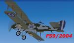
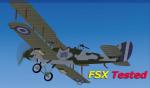
FS9 FS2004 DeHavilland DH-9 Hellenic Royal Navy SPETSES Package
(Category: FS2004 > Vintage)
6.30Mb (917 downloads)
FS9/2004 Hellenic Royal Navy Air Service (NAYTIKH AEROPORIKH YPHRESIA) DeHavilland DH-9
This is a complete package with full VC and 2d panel and gauges.
N.A.Y.received, after the end of WWI, a total of 42 D.H.9s and used them as rec/bombers.After 1926 six of them were transformed in to Hydroplanes (Coming Soon in another repaint). The D.H.9s were used with success by N.A.Y. during the Micrasiatic Campaign (1922). All the D.H.9s were based on Tatoi's and Faliro's Airports, near Athens, until 1932.Original Model by Chris Herring whom i thank for giving me the permition to include the model in this package. For FSX there is another packege listed in the FSX Vintage page. Repaint for the Hellenic colors by Yiannis Katehis Tsetsas.
Posted Jul 28, 2011 16:36 by YIANNIS KATEHIS TSETSAS
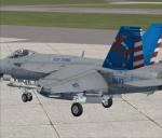
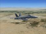
VRS Superbug VX-23 Updated CAG Textures
(Category: FSX > Payware)
2.34Mb (278 downloads)
VRS Superbug VX-23 Salty Dogs updated CAG
textures Requires the Payware VRS Superbug
enjoy repaint by Hornet202
Posted Jul 28, 2011 15:14 by Chris Hammons
.jpg-thumb.jpg)
.jpg-thumb.jpg)
Complete Set of FSX Oil Burner Flight Plans
(Category: FS Navigation > Flight Simulator Navigation)
13.89Mb (475 downloads)
This is a complete set of all 17 of my FSX Oil Burner Flight Plans uploaded earlier. Installation and Usage instructions are inside each individual folder. No changes have been made to the individual flight plans since they were uploaded earlier. Theses 17 routes are located throughout the continental United States. These are great routes for B-52, F-111, B-1B, B-2 A6, A4, Vulcan and any fighter or bomber enthusiasts. Of course you can fly the
routes with any aircraft of your choice. Included in this package are two spectacular gauges by Karol Chlebowski
for TFR flying and Pave Tack which includes many advanced features for bombing, navigation and reconnaissance.
These two gauges will greatly enhance your ability to fly these challenging routes and are a great companion of the flight plans. Another option to download Version 2.1 of my mini panel which has all this functionality and more.
Posted Jul 28, 2011 12:26 by Bill McClellan
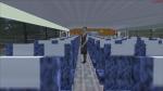
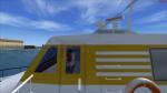
FSX Panel plus Cameras for Hamas Hovercraft - Travel on Land or Water!
(Category: FSX > Misc)
1.81Mb (1764 downloads)
FSX modified panel plus cameras for the Passenger hovercraft ferry from Mitsuya Hamaguchi (Requires hover_v03.zip). Makes the Hovercraft useable in FSX. The 2D panel matches th VC and additional there are 5 external and 6 internal views. Configuration by Erwin Welker.
Required files:
required file
Posted Jul 28, 2011 08:47 by Erwin Welker
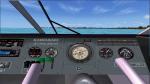
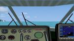
FSX Panel plus Cameras for the Kawasaki Jetfoil
(Category: FSX > Misc)
1.34Mb (628 downloads)
FSX modified panel plus cameras for the Kawasaki Jetfoil from Mitsuya Hamaguchi (Requires Jetfoil_v03.zip). Makes the Jetfoil useable in FSX. The 2-D panel matches th VC and additional there 4 external and 3 internal views. Configuration by Erwin Welker.
Required files:
required file
Posted Jul 28, 2011 08:44 by Erwin Welker
Complete Set of FS2004 Oil Burner Flight Plans
(Category: FS Navigation > Flight Simulator Navigation)
12.10Mb (120 downloads)
This is a complete set of all my FS2004 Oil Burner Flight Plans. Installation and Usage instructions are inside each individual folder. This should simplify the download for those who want all Flight Plans.
Posted Jul 27, 2011 23:01 by Bill McClellan
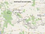
FS2004 Flight Plan for OB-98 Rapid City South Dakota
(Category: FS Navigation > Flight Simulator Navigation)
0.35Mb (130 downloads)
FS2004 Flight Plan for OB-98 Rapid City South Dakota IFR high speed low altitude military training route. This is the seventeenth in a series of FS2004 flight plans I have uploaded. This route goes through both mountainous and flat and rolling terrain in South Dakota, Nebraska, Wyoming and Montana. This route has two different sets of targets. These are great routes for B-52, F-111, B-1B, B-2 A6, A4, Vulcan and any fighter or bomber enthusiasts. Of course you can fly the route with any aircraft of your choice. Included in this package is a gauge by Karol Chlebowski for TFR flying at very low altitude. This gauge will greatly enhance your ability to fly these challenging routes and is a great companion of the flight plans. Another option to download Version 2.0 of my FS2004 mini panel which has all this functionality and more.
Posted Jul 27, 2011 22:35 by Bill McClellan