


All Files > Page 1929
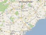
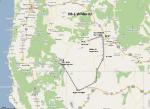
FS2004 Flight Plan for OB-17 Statesboro Georgia
(Category: FS Navigation > Flight Simulator Navigation)
0.44Mb (73 downloads)
FS2004 Flight Plan for OB-17 Statesboro Georgia IFR high speed low altitude military training route. through flat and rolling terrain in North Carolina, South Carolina and Georgia This is the sixth in a series of flight plans I have uploaded. These are great routes for B-52, F-111, B-1B, B-2 A6, A4, Vulcan and any fighter or bomber enthusiasts. Of course you can fly the route with any aircraft of your choice. Included in this package is a gauge by Karol Chlebowski for TFR flying at very low altitude. This gauge will greatly enhance your ability to fly these challenging routes and is a great companion of the flight plans. Another option to download Version 2.0 of my FS2004 mini panel which has all this functionality and more.
Posted Jul 27, 2011 22:20 by Bill McClellan
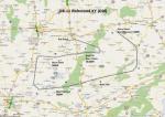
FS2004 Flight Plan for OB-11 Richmond KY (Old)
(Category: FS Navigation > Flight Simulator Navigation)
0.09Mb (53 downloads)
FS2004 Flight Plan for OB-11 Richmond KY (Old) IFR high speed low altitude military training route. This is the fifth in a series of flight plans I have uploaded. These are great routes for B-52, F-111, B-1B, B-2 A6, A4, Vulcan and any fighter or bomber enthusiasts. Of course you can fly the route with any aircraft of your choice. Included in this package is a gauge by Karol Chlebowski for TFR flying at very low altitude. This gauge will greatly enhance your ability to fly these challenging routes and is a great companion of the flight plans. Another option to download Version 2.0 of my FS2004 mini panel which has all this functionality and more.
Posted Jul 27, 2011 22:18 by Bill McClellan
-1.jpg-thumb.jpg)
FS2004 Flight Plan for OB-11 Richmond Kentucky
(Category: FS Navigation > Flight Simulator Navigation)
0.36Mb (62 downloads)
FS2004 Flight Plan for OB-11 Richmond Kentucky IFR high speed low altitude military training route. This route goes through mountainous terrain in Tennessee, North Carolina, Virginia and Kentucky. This is the fourth in a series of flight plans I have uploaded. These are great routes for B-52, F-111, B-1B, B-2 A6, A4, Vulcan and any fighter or bomber enthusiasts. Of course you can fly the route with any aircraft of your choice. Included in this package is a gauge by Karol Chlebowski for TFR flying at very low altitude. This gauge will greatly enhance your ability to fly these challenging routes and is a great companion of the flight plans. Another option to download Version 2.0 of my FS2004 mini panel which has all this functionality and more.
Posted Jul 27, 2011 22:17 by Bill McClellan
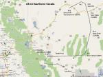
FS2004 Flight Plan for OB-10 Hawthorne Nevada
(Category: FS Navigation > Flight Simulator Navigation)
0.31Mb (73 downloads)
FS2004 Flight Plan for OB-10 Hawthorne Nevada IFR high speed low altitude military training route. This is the third in a series of flight plans I have uploaded . This route goes through both mountainous and flat and rolling terrain in California, and Nevada. These are great routes for B-52, F-111, B-1B, B-2 A6, A4, Vulcan and any fighter or bomber enthusiasts. Of course you can fly the route with any aircraft of your choice. Included in this package is a gauges by Karol Chlebowski for TFR flying at very low altitude. This gauge will greatly enhance your ability to fly these challenging routes and is a great companion of the flight plans. Another option to download Version 2.0 of my FS2004 mini panel which has all this functionality and more.
Posted Jul 27, 2011 22:15 by Bill McClellan
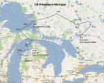
FS2004 Flight Plan for OB-9 Bayshore Michigan
(Category: FS Navigation > Flight Simulator Navigation)
0.45Mb (82 downloads)
FS2004 Flight Plan for OB-9 Bayshore Michigan IFR high speed low altitude military training route. This is the second in a series of flight plans I have uploaded. This route goes through flat and rolling terrain and over water in Ontario and Michigan. These are great routes for B-52, F-111, B-1B, B-2 A6, A4, Vulcan and any fighter or bomber enthusiasts. Of course you can fly the route with any aircraft of your choice. Included in this package is a gauge by Karol Chlebowski for TFR flying at very low altitude. This gauge will greatly enhance your ability to fly these challenging routes and is a great companion of the flight plans. Another option to download Version 2.0 of my FS2004 mini panel which has all this functionality and more.
Posted Jul 27, 2011 22:14 by Bill McClellan
FS2004 Flight Plan for OB-1 Wilder Idaho
(Category: FS Navigation > Flight Simulator Navigation)
0.30Mb (67 downloads)
FS2004 Flight Plan for OB-1 Wilder Idaho IFR high speed low altitude military training route through mountainous terrain in Oregon, Nevada and Idaho. This is the first in a series of FS2004 flight plans I will upload. These are great routes for B-52, F-111, B-1B, B-2 A6, A4, Vulcan and any fighter or bomber enthusiasts. Of course you can fly the route with any aircraft of your choice. Included in this package is a gauge by Karol Chlebowski for TFR flying at very low altitude. This gauge will greatly enhance your ability to fly these challenging routes and is a great companion of the flight plans. Another option to download Version 2.0 of my FS2004 mini panel which has all this functionality and more.
Posted Jul 27, 2011 22:12 by Bill McClellan

FSX Force Texture Fix
(Category: FSX > Military)
4.79Mb (457 downloads)
This is a replacement for the left and right wing pilots because of the unavailability of the pilots
Required files:
required file
Posted Jul 27, 2011 19:34 by FSX Force

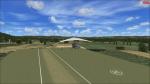
FSX Eferding Airfield, Austria
(Category: FSX > Scenery)
0.00Mb (731 downloads)
The Eferding Airfield in Austria doesn't exist in FSX! That's the reason why I've made it. Wels, Vrsar and Linz Airport are my next big projects! There will be some updates soon. This scenery is only for FSX! Please watch my youtube Channel: http://www.youtube.com/user/FSAG007?feature=mhee
Posted Jul 27, 2011 15:47 by Alex Grünwald
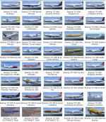
169 Liveries Collection Pack for Default B737-800 V3
(Category: FSX > Civil Jets)
152.43Mb (90574 downloads)
169 Liveries Collection Pack for Default Boeing 737-800. V3 * 6 Default + 19 Air India + 144 real and defunct airlines liveries from all over the world by various artists. ** - The ZIP file contains 169 Liveries for the Default Boeing 737-800 : 6 Default, 19 Air India, and other 144!! - Fixed Airlines.cfg / Aircraft.cfg so that many existing CALLSIGN work and are spelled correctly in game. - Deleted hundreds of MB of un-useful textures or images left in texture folder by most livery designers. - Added new THUMBNAIL for each plane were missing or not well visible so that the preview is good. - Added real CALLSIGN at the end of each airline description to set it correctly from game menu. - Added for each plane a description of the airline it belong to, taken from Wikipedia. - Added Smoke System - Added different languages (ENG, ITA, FRA, GER) "aircraft.cfg", default is the english version. - Added a little SOUND MOD (Hostess radio security messages) invented and developed by me. - Added TAXI lights using existing fsx lights made by me. - All new planes have been tested and work perfectly. - Add-On tested only on FSX with SP1 and SP2 installed. Changes and fix compared with 151 Liveries Collection Pack. - New "aircraft.cfg" and updated "airlines.cfg" which fix a mistakes of 151 Liveries Pack. - Fixed Caribbean Airlines plane which wasn't working due to a typying mistake in "aircraft.cfg". - Fixed Vietnam Airlines's CALLSIGN to "VIETNAM" so now will be spelled in game's ATC. - All new planes have been cleaned from unuseful textures and other useless files. - All new planes have been tested and work perfectly. - Added a folder with Wikipedia Airlines's urls. This is the full list of the other 144 liveries includes in the pack : Adam Air, Aeromexico, Aerosvit, Air Asia Indonesia, Air Astana, Air Berlin, Air Canada, Air China, Air China Olympic, Air Europa, Air France, Air Jamaica, Air New Zealand, Air One, Air Slovakia, AirTran Airways, Air Vanuatu, Alaska , Alaska.com, Alaska Spirit of Seattle, Alaska Starliner 75, Alitalia, All Nippon Airways (ANA), ALOHA, American Airlines, America West, Ansett Australia, Austrian Airlines, Batavia Air (x3), BMI baby, British Airways, Brussels Airlines, Bulgaria Air, Caribbean Airlines, Cebu Pacific Air, Continental Airlines, Copa Airlines, Corendon Airlines, Cubana De Aviacion, Cyprus Airways, Czech Airlines, Delta Airlines, DHL Cargo, EasyJet, Eastern Airlines, El Al (Israel), EgyptAir, Europe Airpost, FedEx Cargo, Ferrari, Ferrari Cargo, Finnair, First Choice, Flash Airlines, Fly Dubai, Flyglobespan, Frontier Airlines, Garuda Indonesia, Garuda SkyTeam, GOL, Gulf Air, Hainan Airlines (x2), IRONMAIDEN, Japan Airlines (JAL), JAT Airways (old and new), Jet2 (grey and white), JetAmerica, JetTime, Kenya Airways, Landmark (Coliseum tail), Lion Air (Indonesia), LOT (Polish Airlines), Lufthansa, Luxair, Malaysia Airlines, MALEV, Mexicana (x4), Military Woodland Camo, Mongolian Airlines (MIAT), Montenegro Airlines, Myanmar Airlines (MAI) , NASA, NAVY, Norwegian Air, Northwest (NWA), OceanAir (Avianca), Olympic Airlines, Pan-Am, Philippine Airlines, PIA (Pakistan Intenrational Airlines), Prague (Czech Republic), Primera Air JetX (Iceland), PrivatAir, Qantas, Ryanair, Ryanair Guinness, Ryanair Kilkenny, Ryanair Vodafone, Scandinavian Airlines (SAS), Singapore Airlines, South African Airways, Southwest Airlines (Blue, Gold, New Mexico), Sterling (Australia), SunExpress, Swiss Air, TAM (Brasil), TAROM (Romania), Thomson Airways, Transavia, TUIfly (x7), Turkish Airlines, Ukraine International Airlines (UIA), UNITED (old and new), UPS Cargo, US Airways, Varig (old and new), VASP (Brazil) , V Australia, Vietnam Airlines, Virgin (blue and red), WestJet, XL Airways, XL Airways Excel.com, XL Airways Oger Tours and XL Airways Viking. Read full instruction to install all textures or individually.
Posted Jul 27, 2011 04:25 by Edoardo Ammannati
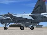
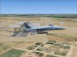
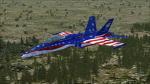
VRS Superbug VFA-2 Bounty Hunters Textures
(Category: FSX > Payware)
2.58Mb (547 downloads)
VRS Superbug VFA-2 Bounty Hunters LINE textures. Requires the payware VRS Superbug
Posted Jul 27, 2011 01:46 by Chris Hammons