


All Files > Page 1895
-2.jpg-thumb.jpg)
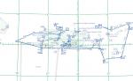
FSX Flight Plans for Current Low Altitude Military Training Routes for the US Territories of Guam and Puetro Rico
(Category: FS Navigation > Flight Simulator Navigation)
1.56Mb (427 downloads)
FSX Flight Plans for current low altitude military training route for the US Territories of Guam and Puetro Rico.
This package includes 9 individual flight plans for IFR, VFR and Slow Speed Routes. These are great routes for B-52, F-111, B-1B, B-2 A6, A4, Vulcan and any fighter or bomber enthusiasts. Of course you can fly the route with any aircraft of your choice. Also included in this package are two spectacular gauges by Karol Chlebowski for TFR flying and Pave Tack which ncludes many advanced features for bombing,navigation and reconnaissance. these two gauges will greatly enhance your ability to fly these challenging routes and are a great companion of the flight
plans. Another option is to download Version 2.1 of my mini panel which has all this functionality and more.
Posted Sep 16, 2011 03:21 by Bill McClellan
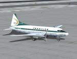
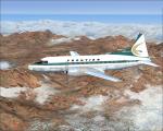
Frontier Convair 340 Textures
(Category: FS2004 > Vintage)
4.00Mb (511 downloads)
FS9/FSX Frontier experimental 1964 textures for Tom Gibson/ Greg Pepper Convair 340.
Textures by Gary Harper. These textures depict N73106 about 1964.
Required files:
required file
Posted Sep 16, 2011 01:06 by Gary Harper
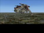
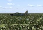
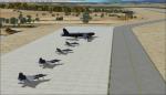
FSX Republic Gunship (Final)
(Category: FSX > Misc)
14.86Mb (3341 downloads)
This is my Star Wars Episode 2 LAAT/I or better known as the Republic Gunship. I believe it is a first ever to, I don't know of any other one for fsx ever made until now. It's not anything amazing no panel no vc. It's just something I threw together using model converter x, google sketchup, and gmax. Enjoy. This is "for now" the final version. I am going to learn how to make animations in gmax. So I will be releasing a new animated ship soon. Feel free to tweak and edit it.
Posted Sep 16, 2011 00:45 by Skyler Henry
FSX Golden Age Simulations WACO RNF Wooden Special Texture
(Category: FSX > Payware)
3.81Mb (270 downloads)
This is a special wooden texture for the payware Golden Age Simulations WACO RNF model for FSX. have fun!
Posted Sep 16, 2011 00:36 by Ken Pochinko

FSX Flight Plans for Current Low Altitude Military Training Routes in the Alaska
(Category: FS Navigation > Flight Simulator Navigation)
1.71Mb (456 downloads)
FSX Flight Plans for current low altitude military training route in Alaska. This package includes 53 individual flight plans for IFR, VFR and Slow Speed Routes. These are great routes for B-52, F-111, B-1B, B-2 A6, A4, Vulcan and any fighter or bomber enthusiasts. Of course you can fly the route with any aircraft of your choice. Also included in this package are two spectacular gauges by Karol Chlebowski for TFR flying and Pave Tack which includes many advanced features for bombing, navigation and reconnaissance. These two gauges will greatly enhance your ability to fly these challenging routes and are a great companion of the flight plans. Another option is to download Version 2.1 of my mini panel which has all this functionality and more.
Posted Sep 15, 2011 16:55 by Bill McClellan
-1.jpg-thumb.jpg)
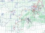
FSX Flight Plans for Current Low Altitude Military Training Routes in the Northwesternl U.S.
(Category: FS Navigation > Flight Simulator Navigation)
5.38Mb (443 downloads)
FSX Flight Plans for current low altitude military training route in the Northwestern U.S. This package includes 75 individual flight plans for IFR, VFR and Slow Speed Routes. These are great routes for B-52, F-111, B-1B, B-2 A6, A4, Vulcan and any fighter or bomber enthusiasts. Of course you can fly the route with any aircraft of your choice. Also included in this package are two spectacular gauges by Karol Chlebowski for TFR flying and Pave Tack which includes many advanced features for bombing, navigation and reconnaissance. These two gauges will greatly enhance your ability to fly these challenging routes and are a great companion of the flight plans. Another option is to download Version 2.1 of my mini panel which has all this functionality and more.
Posted Sep 15, 2011 16:41 by Bill McClellan
-1.jpg-thumb.jpg)
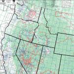
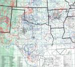
FSX Flight Plans for Current Low Altitude Military Training Routes in the Southwestern U.S.
(Category: FS Navigation > Flight Simulator Navigation)
7.03Mb (801 downloads)
FSX Flight Plans for current low altitude military training route in the Southwestern U.S. This package includes 142 individual flight plans for IFR, VFR and Slow Speed Routes. These are great routes for B-52, F-111, B-1B, B-2 A6, A4, Vulcan and any fighter or bomber enthusiasts. Of course you can fly the route with any aircraft of your choice. Also included in this package are two spectacular gauges by Karol Chlebowski for TFR flying and Pave Tack which includes many advanced features for bombing, navigation and reconnaissance. These two gauges will greatly enhance your ability to fly these challenging routes and are a great companion of the flight plans. Another option is to download Version 2.1 of my mini panel which has all this functionality and more.
Posted Sep 15, 2011 16:26 by Bill McClellan
-1.jpg-thumb.jpg)
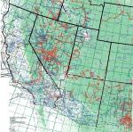
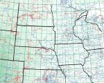
FSX Flight Plans for Current Low Altitude Military Training Routes in the North Central U.S.
(Category: FS Navigation > Flight Simulator Navigation)
5.13Mb (291 downloads)
FSX Flight Plans for current low altitude military training route in the North Central U.S. This package includes 77 individual flight plans for IFR, VFR and Slow Speed Routes. These are great routes for B-52, F-111, B-1B, B-2 A6, A4, Vulcan and any fighter or bomber enthusiasts. Of course you can fly the route with any aircraft of your choice. Also included in this package are two spectacular gauges by Karol Chlebowski for TFR flying and Pave Tack which includes many advanced features for bombing, navigation and reconnaissance. These two gauges will greatly enhance your ability to fly these challenging routes and are a great companion of the flight plans. Another option is to download Version 2.1 of my mini panel which has all this functionality and more.
Posted Sep 15, 2011 16:03 by Bill McClellan
FSX Flight Plans for Current Low Altitude Military Training Routes in the South Central U.S.
(Category: FS Navigation > Flight Simulator Navigation)
4.74Mb (308 downloads)
FSX Flight Plans for current low altitude military training route in the South Central U.S. This package includes 179 individual flight plans for IFR, VFR and Slow Speed Routes. These are great routes for B-52, F-111, B-1B, B-2 A6, A4, Vulcan and any fighter or bomber enthusiasts. Of course you can fly the route with any aircraft of your choice. Also included in this package are two spectacular gauges by Karol Chlebowski for TFR flying and Pave Tack which includes many advanced features for bombing, navigation and reconnaissance. These two gauges will greatly enhance your ability to fly these challenging routes and are a great companion of the flight plans. Another option is to download Version 2.1 of my mini panel which has all this functionality and more.
Posted Sep 15, 2011 15:32 by Bill McClellan
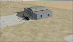
Malaga, Spain, LEMG scenery v.1.1
(Category: FSX > Scenery)
0.00Mb (1446 downloads)
Added scenery on the military apron and the 6 helipads that were missing in the default FSX Malaga scenery in Spain. This is my first scenery project so please enjoy!
Posted Sep 15, 2011 13:23 by Haydn Jakes