


All Files > Page 1899
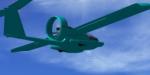
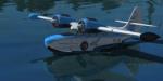
Sky Blue Stingray Texures
(Category: FSX > Props)
6.39Mb (634 downloads)
Sky Blue textures only for the Stingray Prototype Package by Simon Smeiman. Created by Club508.
Required files:
required file
Posted Sep 11, 2011 17:29 by Club508
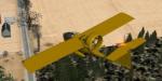
Yellow Stingray Textures
(Category: FSX > Props)
6.42Mb (626 downloads)
Yellow textures for the Stingray Prototype Package by Simon Smeiman. Created by Club508.
Required files:
required file
Posted Sep 11, 2011 17:21 by Club508
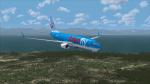
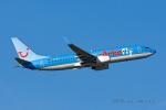
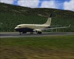
Arkefly Boeing 737-800 Textures
(Category: FSX > Civil Jets)
8.96Mb (1935 downloads)
Arkefly textures for the default Boeing 737-800. Painted with nice colors, flags on the back, and the original Arkefly logo. Arkefly is a Dutch charter airline and a part of the German TUI Group.
Posted Sep 11, 2011 09:31 by Lars V.
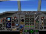
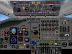
Douglas DC 8-70 2D Panel (Standard screen)
(Category: FSX > Panels)
1.62Mb (2231 downloads)
Standard screen 2D panel (no VC) for the Douglas DC 8-70. See instructions for installation and configuration in the readme.txt file. All custom gauges in xml. This will enable the HJG DC-8 to be used in FSX with a 2d panel.
Required files:
required file
Posted Sep 11, 2011 04:05 by Philippe Wallaert
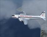
Flying Tiger Line DC-4 Textures
(Category: FSX > Vintage)
3.17Mb (529 downloads)
FS9 Flying Tiger Line textures for the JBK DC-4 V.3 by Jens Kristensen. These textures represent Flying Tiger's livery for the DC-4 about 1949.
Textures by Gary Harper.
Required files:
required file
Posted Sep 11, 2011 00:22 by Gary Harper
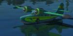
Grumman Goose G21A Forest Lakes Textures Set
(Category: FSX > Props)
22.80Mb (1121 downloads)
Created by Club508. These are some of the default liverys slightly altered to give them colors with a more forest-like feel. The new colors are a green, sky blue, blue, and orangy-brown. There are 8 diffrent textures. For the default Grumman Goose G21A.
Posted Sep 10, 2011 14:03 by Club508
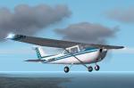
FS2002/2004 Skylane Textures
(Category: FS2004 > Props)
0.88Mb (333 downloads)
A repaint of the default Cessna 182s to add variaty to your flightline. Repaint by Don Brynelsen using the paintkit by Andrew Van Sickle
Posted Sep 10, 2011 13:21 by Don Brynelsen
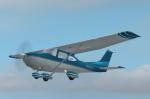
FS2002/2004 Skyhawk Textures
(Category: FS2004 > Props)
1.72Mb (356 downloads)
Repaint Textures for the default Cessna 172 to add variety to your flightline. Repaint by Don Brynelsen using the paintkit by Mark Rooks.
Posted Sep 10, 2011 13:19 by Don Brynelsen
POSKY 737-700 BBJ Modification
(Category: FSX > Civil Jets)
0.01Mb (1561 downloads)
This is a redesigned Aircraft.cfg file for the default POSKY 737-700 With winglets, converting it into a Boeing Business Jet (BBJ). Config file only! Fuel flow and engine performance have been reworked to mimic realistic operating criteria. It is based information available from Conklin & De Decker, Business & Commerical Aviation, CFM International, Boeing and other various sources. Some Basic Specs: BOW: 95,620 lbs // MDTW: 171,500 lbs // MTOW: 171,000 lbs // MLW: 134,000 lbs // Fuel: 69,981 lbs ( 10,737 gallons) - 9 PATS AUX Tanks. Range Estimates (with NBAA IFR 200 NM Reserves): 8 pax: 6,141 nm. Typical Crew/Pax Seating: 4+19 (4 crew and 19 passengers)
Required files:
required file
Posted Sep 10, 2011 13:19 by S. Lisle Horne
FS2002/2004 Skylane Textures
(Category: FS2004 > Props)
0.90Mb (245 downloads)
Repaint textures for the default Cessna 182s. Repaint by Don Brynelsen using the paintkit by Andrew van Sickle
Posted Sep 10, 2011 13:16 by Don Brynelsen