


All Files > Page 1903
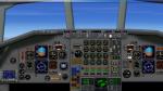
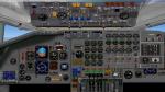
Douglas DC 8-70 2D panel (wide screen)
(Category: FSX > Panels)
1.76Mb (1117 downloads)
Wide screen 2D panel (no VC) for the Douglas DC 8-70. See instructions for installation and configuration in the readme.txt file. All custom gauges in xml.
Posted Sep 6, 2011 13:32 by Philippe Wallaert
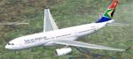
FSX South African Airways Airbus A330-200 Textures V2
(Category: FSX > Civil Jets)
1.67Mb (2058 downloads)
Textures only for Thomas Ruth's A330-200 model in the colors of SAA's first A330-200, registered ZS-SXZ. Improvements include new tailfin and winglets, resized titles, new registrations, and the aircraft's name under the cockpit windows as per the real plane. Requires SP1, SP2, or the Acceleration expansion pack by Microsoft or the model will not be displayed correctly.
Required files:
required file
Posted Sep 5, 2011 22:10 by Ryan Gabuyo
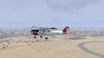
N7177G Textures for the Default C172
(Category: FSX > Props)
1.90Mb (382 downloads)
This is a repaint based on the N7177G USAF replica. Texture by Benjamin Rothstein.
Posted Sep 5, 2011 20:29 by Benjamin Rothstein
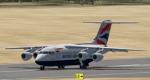
Added views for the BAe 146-100
(Category: FSX > Civil Jets)
0.07Mb (1698 downloads)
Additionnal views ( defined by camera definitions in the aircraft.cfg file ) for
the beautiful BAe 146-100 by Premier Aircraft Design.
A total of 7 cameras pointing at the aircraft and 6 virtual cockpit cameras.
See Read me.txt file for very easy installation procedures AND a special one .
Also included is a text file that contains the new camera definitions.
Enjoy !
Required files:
required file
Posted Sep 5, 2011 18:22 by Marc Renaud
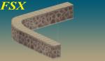
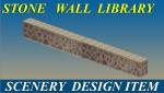
FSX Yiannis Stone Wall Library
(Category: FS Design > Scenery Design Objects)
0.56Mb (1078 downloads)
Yiannis Stone Wall Library for Scenery Builders
Three Different styles of Round and Strait stone walls with Photo Real textures.
They are intended to use for scenery building with instant scenery or other object placement tools.
This is tested in FSX since the textures are DXT5.
Complete Freeware package
By :Yiannis Katehis Tsetsas.
Posted Sep 5, 2011 08:19 by YIANNIS KATEHIS TSETSAS
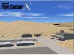
Area 51 Scenery Package
(Category: FSX > Scenery)
1.95Mb (7681 downloads)
Area 51 Airbase, Nevada. I don't think Area 51 needs explanation. I just say that it's a secret base (the most famous in the world) which operates since the sovietic war (also known as "cold war"). It's located on a protected zone in the Nevada desert. Only authorized personnel allowed. In my work I did the best. I think that it is the most similar project than ever. Try to believe you are there!
Anything in this scenery is new: fsx did not a good job with the default, so I started from zero. Now it's full of objects.
Posted Sep 5, 2011 07:36 by Skara Scenery
3rd Runway for Vienna Schwechat Airport
(Category: FSX > Scenery)
0.42Mb (1067 downloads)
Today the Vienna Schwechat Airport has two Runways! There is more and more traffic. So the Airport Owner decided to make a extension...
Posted Sep 5, 2011 07:01 by Alex Grünwald
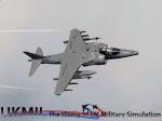
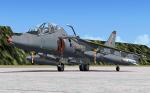
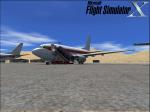
UKMIL FSX Harrier Gr5/7 and T10 Package
(Category: FSX > Military)
55.39Mb (34433 downloads)
UKMIL FSX Harrier Gr57 and T10 Package. Welcome to the UKMIL Harrier Package for FSX. Comprehensive package including clickable VC.
Posted Sep 4, 2011 13:42 by UKMIL
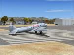
American Eagle Textures for the default DC-3-3
(Category: FSX > Vintage)
2.24Mb (755 downloads)
American Eagle textures for the default fsx Douglas DC-3
Posted Sep 4, 2011 13:33 by Zane Gray
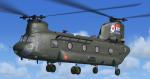
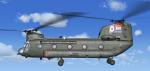
RAF Chinook 30th Anniversary Textures
(Category: FSX > Helicopters)
2.23Mb (5300 downloads)
RAF Chinook 30th Anniversary Textures.
This pack will give you the 2011 30th anniversary textures for the ukmil Boeing Chinook.
Requires the freeware RAF Boeing Chinook by UKMil.
Textures by UKMIL [www.ukmil.org.uk]
Required files:
required file
Posted Sep 4, 2011 10:29 by UKMIL