


All Files > Page 1905
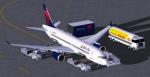
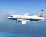
Delta Connection CSeries CS100 V2
(Category: FS2004 > Civil Jets)
5.45Mb (2142 downloads)
FS2004 Delta Connection CSeries CS100 V2. Version 2 includes aircraft design improvements,
This CamSim Version 2 is also includes four aircrafts with different new Animated Ground Servicing (AGS).
Model design and paint by Camil Valiquette.
Posted Sep 3, 2011 09:11 by Camil Valiquette

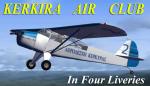
FS 2004 Taylorcraft Auster 5 Aeroleshi Kerkiras (Corfu Air Club) Package in 4 Liveries.
(Category: FS2004 > Props)
14.71Mb (2927 downloads)
One the best trainers you can get. Take off at about 70 meters and glide to approach as low as 30 mph .
This repaint of Kerkira Air Club was created especially for my Kerkira and Othonoi
(LGOT)Scenery due to Fanari Airport Short runway (1100 ft with overrun of 250 ft).
This Scenery will be released soon. Many thanks to Bjorn Bucher for the model.
There are four repaints of Red, Sky Blue, Orange and Yellow with Numbers 1-4 in this package.
This is a Complete freeware package including fully animated parts VC and 2d Panel and Sound.
Textures Repaint for 2004 1n 16 bit bmp Format by: Yiannis Katehis Tsetsas
Posted Sep 3, 2011 01:20 by One the best trainers you can get. Take off at about 70 meters and glide to approach as low as 30 mph .
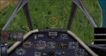
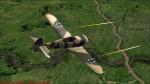
CFS2/FS2004 FW190A-C 2D Panel
(Category: CFS2 > Panels)
4.21Mb (510 downloads)
This is a modded panel from a download I had for years. I refined the bitmaps and rarranged the gauges to more acurately portray the FW190A-4 I've been working on.
Gauges are included from JWB,MAPE,and VW and stock. Watch for my FW190 on the payware downloads.
Posted Sep 3, 2011 00:54 by vincent farnham
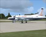
Eastern 1961 CV440 Textures
(Category: FS2004 > Vintage)
3.72Mb (606 downloads)
FS9/FSX Eastern 1961 "Silver Falcon" textures for Tom Gibson/ Greg Pepper Convair 440.
Textures by Gary Harper. These textures depict N9306 about 1961.
Note: Use in FSX will require a panel modification. Add a 2d FSX panel!
Required files:
required file
Posted Sep 3, 2011 00:32 by Gary Harper
UPDATE-to "He went North to the Swamps" Mission
(Category: FSX > Missions)
0.05Mb (693 downloads)
This is an important Update to the Scenery and Texture directory of this Flight Adventure. You will not find Joe without them!!!
Required files:
required file
Posted Sep 3, 2011 00:24 by Gera Godoy Canova
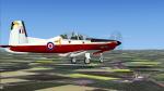
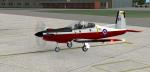
Iris Pilatus PC-9 - RAF Trainer Fictional Textures
(Category: FSX > Props)
4.65Mb (569 downloads)
Textures for the ex payware Iris Pilatus PC-9 - RAF TRAINER livery.
Fictional repaint by Dave Gore (fooflyer) using the IRIS PRO Series PC-9 paintkit by DAVID BRICE.
Required files:
required file
Posted Sep 2, 2011 10:01 by Dave Gore fooflyer
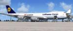
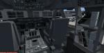
Boeing 747-823F Lufthansa Cargo with VC
(Category: FSX > Civil Jets)
28.45Mb (9407 downloads)
Boeing 747-823F Lufthansa Cargo. VC and other edits to make it work in FSX. Used edited version of the default B747-400 VC. Project Opensky Freighter 747-823F model. Opening cargo doors on nose and both sides with service vehicles. Opening Passenger (L1) door: Shift + E ( Opening door ) Opening Cargo Doors: Shift + E then quickly 2 Opening Passenger (L2) door: Shift + E then quickly 3 Opening Bulk Cargo Door: Shift + E then quickly 4. Lufthansa Cargo textures by Stefan Bree. FSX portover by Chris Evans.
Posted Sep 2, 2011 01:06 by Chris Evans
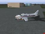
Beechcraft -C90B-Airborne-Critical-Care
(Category: FS2004 > Props)
6.10Mb (2220 downloads)
Airborne Critical Care was from Smithfield, NC located at KJNX. This business was a medical transport from about 2005 till 2007. Model by Dee Waldron. Panel by Michael Verlin. Textures by J.B. Barbour
Posted Sep 1, 2011 21:12 by J.B. Barbour

Punta Cana Airport, Dominican Republic Update
(Category: FS2004 > Scenery)
0.03Mb (4189 downloads)
Punta Cana Airport, Dominican Republic, with the new runway now included.
Posted Sep 1, 2011 17:45 by Alberto Thomas - Costa Rica
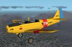
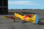
FS2004 US Navy PT-19 Textures
(Category: FS2004 > Vintage)
0.35Mb (467 downloads)
My idea of what a Fairchild PT-19 trainer might look like in US Navy colors based on Harm's Stearman from the TV show JAG. Textures only, you need Denis Da Silva's original PT-19 or my US version of it to use.
Required files:
required file
Posted Sep 1, 2011 13:29 by Don Brynelsen