


All Files > Page 1908
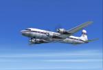
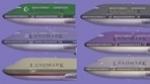
Aerovias Sud Americana DC-7 Textures
(Category: FSX > Vintage)
6.29Mb (389 downloads)
Aerovias Sud Americana textures for the FS2002, FS9, and FSX DC-7 aircraft by Greg Pepper and Tom Gibson (also available at Calclassic.com.)
Textures by Gary Harper.
Required files:
required file
Posted Aug 29, 2011 18:10 by Gary Harper
A380 Real Cockpit Radio Stack fix
(Category: FSX > Civil Jets)
0.00Mb (4370 downloads)
A380 Real Cockpit Radio Stack fix. Fixes the VC so now the radios panel is available. Also includes a sound file for those who got the no sound version.
Required files:
required file
Posted Aug 29, 2011 13:58 by admin
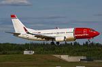
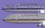
Luxair, Arkefly and Norwegian Texture Pack for FSX Default Boeing 737-800
(Category: FSX > Civil Jets)
9.73Mb (3086 downloads)
These are textures for the FSX Default Boeing 737-800. There are three textures; Luxair, Arkefly, and Norwegian Airlines. Each texture is as accurate to the real thing as I could get them. Come with Readme for installation.
Posted Aug 29, 2011 13:02 by Benjamin Bookman
FS2002 Default Boeing 747-400 Replacement Textures Figuring Typical Passenger and Cargo Airlines Worldwide
(Category: FS2002 > Civil Jets)
4.19Mb (1149 downloads)
FS2002 Default Boeing 747-400 Replacement Textures Figuring Typical Passenger and Cargo Airlines Worldwide. Need Some Text Editing. With a French Readme Too. by G. Guichard
Posted Aug 29, 2011 12:14 by G. Guichard
FS2002 Default Boeing 777-300 Replacement Textures Figuring Two Typical Passenger Airlines Worldwide
(Category: FS2002 > Civil Jets)
0.73Mb (696 downloads)
FS2002 Default Boeing 777-300 Replacement Textures Figuring Two Typical Passenger Airlines Worldwide. Need Some
Text Editing. With French Text Too. Freeware. by G. Guichard
Posted Aug 29, 2011 12:08 by G. Guichard
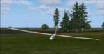
FS2004 SZD 30 Pirat Glider
(Category: FS2004 > Gliders and Ultralites)
0.64Mb (982 downloads)
FS2004 SZD 30 Pirat Glider
Manufactured in Poland, popular Polish Club Class sailplane
The HA-4379 served the Hungarian Posta Aero Club
FS2K Designed by Oscar Pedrosa, gauges by Wolfgang Piper
Mods for FS2K4 works by George Csillag
Posted Aug 29, 2011 11:56 by George Csillag
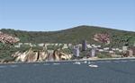
FS2002 Monaco Scenery
(Category: FS2002 > Scenery)
0.65Mb (1056 downloads)
Monaco Scenery for FS2002, With A French Readme Also
Posted Aug 29, 2011 11:54 by G. Guichard
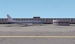
FS2002 Basic Additions to Geneve-Cointrin (LSGG)
(Category: FS2002 > Scenery)
0.93Mb (364 downloads)
FS2002 Basic Additional Scenery and Objects to Genève-Cointrin (LSGG), With A French Readme Also
Posted Aug 29, 2011 11:53 by G. Guichard

FS2002 French-Speaking Flying Logbook
(Category: FS2002 > Misc)
0.14Mb (125 downloads)
Web Browser FS2002 Flying Logbook for PPL Pilots of French-Speaking Areas and Countries. Need to Know to Edit a HTML Page. Caution! Readme in French Only
Posted Aug 29, 2011 11:51 by G. Guichard
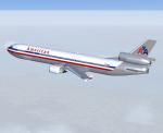
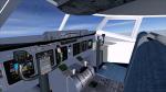
McDonnell Douglas MD-11P Package
(Category: FSX > Civil Jets)
2.86Mb (7341 downloads)
American Airlines (1994) livery.
Long range wide body airliner, full package for FSX/SP2.
Custom panel & VC, sound, full moving parts, dynamic shine, operating passenger,
crew & cargo doors, HTML check/ref lists.
This is a re-issue of our original model with new bare metal & white textures and improved flight dynamics.
By Jean-Pierre Brisard, Barry Blaisdell & Bob May -Premier Aircraft Design.
Posted Aug 29, 2011 10:03 by Bob May (PAD)