


All Files > Page 1910
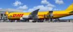
Boeing 747-823F DHL Cargo Package
(Category: FSX > Civil Jets)
28.15Mb (11306 downloads)
Boeing 747-823F DHL Cargo. VC and other edits to make it work in FSX. Used edited version of the default B747-400 VC. Project Opensky Freighter 747-823F model. Opening cargo doors on nose and both sides with service vehicles. Opening Passenger (L1) door: Shift + E ( Opening door )
Opening Cargo Doors: Shift + E then quickly 2
Opening Passenger (L2) door: Shift + E then quickly 3
Opening Bulk Cargo Door: Shift + E then quickly 4. DHL textures by
Stefan Bree. FSX portover by Chris Evans.
Posted Aug 27, 2011 11:14 by Chris Evans
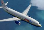
Boeing 737-800 Arkefly/Miami Air Textures
(Category: FSX > Civil Jets)
8.63Mb (760 downloads)
Arkefly/Miami Air textures for the default B737-800. It has a yellow stripe with a deep blue underbody. Created by Club508.
Posted Aug 27, 2011 10:54 by Club508
FS2004 Aerodrome de Bex (Bex Airfield) - LSGB, Switzerland
(Category: FS2004 > Scenery)
0.09Mb (889 downloads)
This small Swiss airport was forgotten in FS. I have created a basic reproduction using "Airport Design Editor" and pictures I took of the airfield. The buildings aren't exact, even though I did place the hangars, restaurant and office in the right locations. The runway is real enough, with lights etc... Enjoy!
Posted Aug 27, 2011 10:34 by Alexis Chevrie
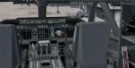
FSX Vertical Speed Gauge with Audio Fixed
(Category: FS Gauges > FS Gauges)
0.19Mb (1908 downloads)
FSX Vertical Speed Gauge with audio callouts. A V-Speed gauge, that when installed into an aircraft panel will calculate the V1, V2 and V3 take of speeds for civilian aircraft, regardless of load or flap settings. The readout will be displayed in an easy to read format in the 2D cockpit, and also includes aural sounds for 80 knots, V1, Vrotate, and V2 speeds, at which point the VSI should show a positive rate of climb. Original gauge for FS2004 by Jacob Larsen (JEL), and modified for FSX by Anthony Eades. The first installation instructions for the V-Speed gauge "Fsx_jelair04vsp" were incomplete. This meant that the aural sounds were not activated. This download will correct that problem.
Posted Aug 27, 2011 06:37 by Anthony Eades
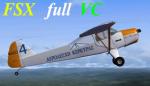
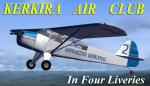
FSX Auster Package - 5 Corfu Air Club in 4 Liveries
(Category: FSX > Props)
10.77Mb (4186 downloads)
FSX Taylorcraft Auster 5 AEROLESHI KERKIRAS (Corfu Air Club)Package in 4 Liveries and full VC!.
One the best trainers you can get. Take off at about 70 meters and glide to approach as low as 30 mph .
This repaint of Kerkira Air Club was created especially for my Kerkira and Othonoi
(LGOT)Scenery due to Fanari Airport Short runway (1100 ft with overrun of 250 ft).
This Scenery will be released soon.Many thanks to Bjorn Bucher for the model .
There are four repaints of Red,Sky Blue,Orange and Yellow with Numbers 1-4 in this package.
This is a Complete freeware package including fully animated parts VC and 2d Panel and Sound.
Textures Repaint in DDS 5, repacking and Testing for FSX by: Yiannis Katehis Tsetsas
Posted Aug 27, 2011 05:49 by YIANNIS KATEHIS TSETSAS
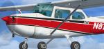
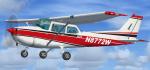
FSX default Cessna 172 repaint N8772W
(Category: FSX > Props)
23.82Mb (1253 downloads)
FSX default Cessna 172SP Skyhawk repaint textures
for the fictional N8772W, a red and white Skyhawk
trimmed in black. Includes both 1024 x 1024 and
2048 x 2048 size textures, 32 bit with no mips
for clarity. Install one, or the other,
or both at once if you wish. Easy installation.
Repaint by Tom Tiedman.
Posted Aug 27, 2011 05:43 by Tom Tiedman
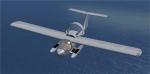
Stingray Prototype Package
(Category: FSX > Props)
13.73Mb (10097 downloads)
Stingray Prototype Package. A nice and fun little aircraft with nice details like fully animated folding wings, good VC and a great handling, nice top speed too. Simple to install with auto installer. Includes manual.
Posted Aug 27, 2011 05:32 by Darnell Metcalf
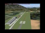
Randall Airport, New York, Scenery Package
(Category: FSX > Scenery)
19.26Mb (1927 downloads)
Randall Airport, Middletown, New York. I have completely rebuilt my Randall Airport. This package now contains photoscenery, SLOPING RUNWAY, and accurately recreated airport scenery with custom buildings. Follow the instructions in the readme.
Posted Aug 26, 2011 13:45 by Scenery Dude
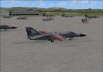
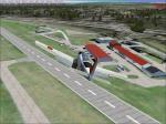
Pigs Down Under, Australian Airbase Scenery
(Category: FSX > Scenery)
4.27Mb (1183 downloads)
This is a simple upgrade to Australian Airbases Amberly and East Sales. It adds Military Combat and Cargo parking spots, Static F-111G aircraft, AI F-111C, F-111G and EF-111A aircraft and flight plans. Each AI aircraft has its own tail number and is addressed by ATC with that tail number. Installer has option to add AI aircraft only if you already have an add-on scenery package for these airbases.
Posted Aug 26, 2011 10:30 by Steve Hess
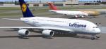
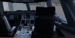
Lufthansa Airbus A380-800 Package
(Category: FSX > Civil Jets)
28.49Mb (17622 downloads)
Lufthansa Airbus A380-800 package for FSX. Package includes the great added VC by 'Dennis' and the glass fix (thank you 'fuzzfly'! Other credits go to the great talent of Project Airbus team for the wonderful model and John Lauwrence for great repaint. I tried to just make this as an update only, but decided it was too clumsy for many users. For this reason I have included the whole package. If there is any objection I will upload the update only. Uploaded by Chris Evans.
Posted Aug 26, 2011 08:38 by Chris Evans