


All Files > Page 1914
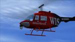
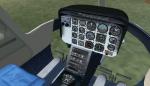
Bell 206B III JetRanger TV News Update and Expansion Package
(Category: FS2004 > Helicopters)
15.16Mb (3385 downloads)
This is a scratch built revision of the default Bell 206B III JetRanger using Gmax. Features highly detailed exterior and virtual cockpit, maximum moving parts, interactive VC, dynamic shine, and reflective textures.This package updates the original TV model which had a bad texture map in the upper wirecutter and adds 3 additional TV News models/textures including the never been released WIS-TV Newshawk version as built and painted by Owen Hewitt
Posted Aug 20, 2011 02:22 by Eagle Rotorcraft Simulations
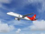
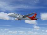
Airbus A319-112 & A320-214 Shenzhen Airlines
(Category: FSX > Civil Jets)
26.13Mb (3527 downloads)
Project Airbus Shenzhen Airlines Airbus A319-112 & A320-214 Complete Package for FSX. The two jets demonstrated are B-6159 "City of Zhengzhou" and B-6550 "City of Lushan". Aircraft Models by Project Airbus with Panel,Sound & Virtual Cockpit from the default A321. Shenzhen Airlines textures by He Lingyuan,China. An Operation Manual written by Project Airbus Members is also included.
Posted Aug 19, 2011 23:35 by He Lingyuan
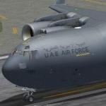
UAE Air Force Virtuavia C17 Textures
(Category: FS2004 > Payware)
9.00Mb (2224 downloads)
This texture depicts the first C17 delivered to the United Arab Emirates Air Force, number 1223 (10-0401).
This texture is an adaptation of the Qatari Emiri Air Force . Requires the payware C-17 from Virtuavia.
Posted Aug 19, 2011 14:52 by Andy Shields
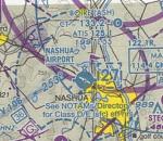
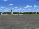
FSX Biore/Nashua Airport, NH, Reworked/Photoscenery
(Category: FSX > Scenery)
19.41Mb (557 downloads)
Airport reworked to real world specs, including all taxiways, parking, hangars, all real buildings on airport grounds,
photoscenery, and GA planes in parking spaces. Built using Airport Design Editor X, SBuilderX, and the default FSX SDK. Nashua Municipal Airport, also known as Boire Field, is a public airport located three miles (5 km) northwest of the central business district (CBD) of Nashua, a city in Hillsborough County, New Hampshire, USA.
Posted Aug 19, 2011 12:29 by FlierForLife
JetBLue Airbus A320-232
(Category: FSX > Civil Jets)
14.51Mb (3914 downloads)
JetBlue's Airbus A320-232 N562JB "Name' Blue, JetBlue" An A320 That Fly's To St. Marteen. Very Detailed Exterior With Wing Views Dynamic Performance with A321 Default Panel And Sound. Uses the model by Ifdg. No VC
Posted Aug 19, 2011 09:04 by Sean Mooney
FS9/FSX Static Aircraft .mdl Maker ("SAMM")
(Category: FSX > Utilities)
0.54Mb (2895 downloads)
Tired of having to program AI (and suffer the overhead) just to have some "eye candy" sitting around your airport. No more! Static Aircraft .mdl Maker ("SAMM") will convert just about any FS8 or FS9 flyable or AI aircraft into a FS9 scenery model. (FSX will display most of these models satisfactorily.) Just "point" SAMM to the aircraft you wish to convert, decide where to save the scenery file and, presto, "eye candy". Most aircraft will convert using SAMM's default settings. Where, the static model is not quite right using default settings or if you want to make your static models as efficient as possible, SAMM includes a set of tools to help you. This re-release is to facilitate future updates from http://stuff4fs.com. Current users will be automatically updated. Previous version had 1195 downloads.
Posted Aug 18, 2011 18:33 by Don Grovestine
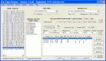
FS2004/FSX AI Flight Planner Version 2
(Category: FSX > Utilities)
1.56Mb (13928 downloads)
AI Flight Planner is a fully-integrated, comprehensive AI flight planning system for both FS9 and FSX. It can use either TTools-format text files or compiled MSFS traffic files as source data. Among its unique features are: departure and arrival times may be specified using local time, airports specified using either ICAO or IATA codes, similar legs in weekly flight plans created automatically, comprehensive error checking and traffic file validation and conversion. Version 2 adds a full range of flight plan and repaint installion capabilities as well as several other new functions. These new capabilities were developed in cooperation with AIG (Alpha-India Group). While intended to meet AIG's specific requirements, AIFP version 2 remains a general purpose tool that may be used to install anyone's flight plans and repaint packages. This re-release of Version 2 is to facilitate future updates from http://stuff4fs.com. Current users of Version 2 will be automatically updated. Previous version had 2736 downloads.
Posted Aug 18, 2011 18:23 by Don Grovestine
Augsburg Airways to Tempelhof
(Category: FSX > Missions)
5.78Mb (1205 downloads)
Beta testing release!
This is a simple flight from Augsburg to Berlin. This mission requires aircraft from premier aircraft design. Add your own board music.I did not manage to compile the reward so I included the .xml file If somebody is able to compile it please send it to me so I can upload a complete package.Thanks. Created using fsx mission editor
Posted Aug 18, 2011 16:40 by David_H
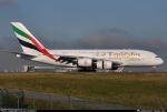
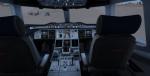
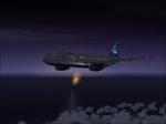
Emirates Airbus A380-800 with Real Cockpit
(Category: FSX > Civil Jets)
32.59Mb (23455 downloads)
Emirates Airbus A380-800 with a new virtual cockpit. Project Airbus presents the Airbus A380-800. Features include dynamic wingflex (with input from several new variables), accurate LAF simulation, parallel bogies, drooping control surfaces, hardcoded double strobes, and over 40 other custom xml parts.
Posted Aug 18, 2011 12:56 by dennis
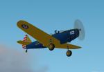
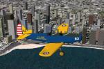
Fs2004 Fairchild PT-19 US Army Air Corp
(Category: FS2004 > Vintage)
0.78Mb (687 downloads)
A repaint of Daniel and Denis Da Silva's PT-19 for FS2002/FS2004 in the livery of a restored example.
You can fly from either 2d cockpit and has a full range of moving parts. Repaint by Don Brynelsen based on a real PT-19 I saw at an Airshow
Posted Aug 18, 2011 12:30 by Don Brynelsen