


All Files > Page 1915
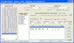
FS2004/FSX AI Flight Planner Version 2
(Category: FSX > Utilities)
1.56Mb (13928 downloads)
AI Flight Planner is a fully-integrated, comprehensive AI flight planning system for both FS9 and FSX. It can use either TTools-format text files or compiled MSFS traffic files as source data. Among its unique features are: departure and arrival times may be specified using local time, airports specified using either ICAO or IATA codes, similar legs in weekly flight plans created automatically, comprehensive error checking and traffic file validation and conversion. Version 2 adds a full range of flight plan and repaint installion capabilities as well as several other new functions. These new capabilities were developed in cooperation with AIG (Alpha-India Group). While intended to meet AIG's specific requirements, AIFP version 2 remains a general purpose tool that may be used to install anyone's flight plans and repaint packages. This re-release of Version 2 is to facilitate future updates from http://stuff4fs.com. Current users of Version 2 will be automatically updated. Previous version had 2736 downloads.
Posted Aug 18, 2011 18:23 by Don Grovestine
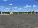
Augsburg Airways to Tempelhof
(Category: FSX > Missions)
5.78Mb (1205 downloads)
Beta testing release!
This is a simple flight from Augsburg to Berlin. This mission requires aircraft from premier aircraft design. Add your own board music.I did not manage to compile the reward so I included the .xml file If somebody is able to compile it please send it to me so I can upload a complete package.Thanks. Created using fsx mission editor
Posted Aug 18, 2011 16:40 by David_H
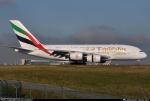
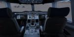
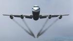
Emirates Airbus A380-800 with Real Cockpit
(Category: FSX > Civil Jets)
32.59Mb (23455 downloads)
Emirates Airbus A380-800 with a new virtual cockpit. Project Airbus presents the Airbus A380-800. Features include dynamic wingflex (with input from several new variables), accurate LAF simulation, parallel bogies, drooping control surfaces, hardcoded double strobes, and over 40 other custom xml parts.
Posted Aug 18, 2011 12:56 by dennis
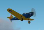
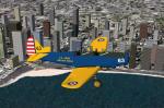
Fs2004 Fairchild PT-19 US Army Air Corp
(Category: FS2004 > Vintage)
0.78Mb (687 downloads)
A repaint of Daniel and Denis Da Silva's PT-19 for FS2002/FS2004 in the livery of a restored example.
You can fly from either 2d cockpit and has a full range of moving parts. Repaint by Don Brynelsen based on a real PT-19 I saw at an Airshow
Posted Aug 18, 2011 12:30 by Don Brynelsen
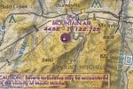
FSX High Altitude STOL Resort Scenery
(Category: FSX > Scenery)
0.01Mb (684 downloads)
-This STOL Resort Scenery makes for a challenging experience. The field is at high altitude (4100), has a short 2,700 ft runway, and has trees surrounding the runway on all sides.
ONly to add to it, the runway is on the vey top of a mounitain, so your visual approach skills will be challenged. Airport made using default FSX SDK.
Posted Aug 18, 2011 09:44 by FlierForLife
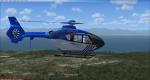
FSX Eurocopter EC-135 Dutch Police Texture
(Category: FSX > Helicopters)
1.15Mb (3288 downloads)
Dutch Police textures for the Heiko Richter EC-135 updated for FSX by Danny Garnier.
Required files:
required file
Posted Aug 18, 2011 09:14 by Club508
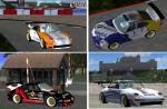
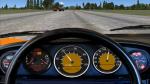
FSX Porsche 911 GT2 with 4 Textures Sets
(Category: FSX > Misc)
6.29Mb (6891 downloads)
FSX Porsche 911 GT2 from the year 1998 (993). Four textures sets are included. The 3D-model and the basic textures (beta version) are made by Jessy Corrales.
Photographical 2-d panel, original Porsche racing sound and 4 sets of repainted textures by Erwin Welker.
Posted Aug 18, 2011 07:27 by Erwin Welker
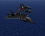

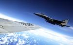
The Ghosts Of Razgriz Textures Collection
(Category: FSX > Military)
6.17Mb (3435 downloads)
A collection of three repaints from the game Ace Combat 5: The Unsung War, These aircraft are painted as the "Ghosts of Razgriz" seen at the end of the game. The aircraft in this pack are the Default F-18, Dino Cattaneo's F-14D, and the IRIS F-22A.
Posted Aug 18, 2011 00:46 by Ryan Calhoun
FSX Convair 990A Engine Smoke Fix
(Category: FSX > Civil Jets)
0.24Mb (2126 downloads)
By request, an FSX Convair 990A engine smoke
coordinates fix for the freeware FSX Historic
Jetliners Group (HJG) Convair 990A
(419Convair_990A.zip) which you must have
previously installed in FSX. Corrects the
misplacement of engine smoke on all
four engine exhaust ports. Can be used with
the existing HJG thicker, heavier smoke,
or gives you the option of a thinner, lighter
engine smoke. More screenshots for
thick smoke vs. thin smoke comparison in the
"Zip file preview" section. Easy installation.
By Tom Tiedman
Required files:
required file
Posted Aug 17, 2011 18:18 by Tom Tiedman
Iris F-15C & D Flight Dynamics Update
(Category: FSX > Military)
0.01Mb (2932 downloads)
(Link corrected) Iris F-15C & D Flight Dynamics Update. You need the F-15C and D by iris modified for fsx.
This changes the handling so that the F-15 will become slightly less agile than the
F-16, being closer to reality.
Required files:
required file
Posted Aug 17, 2011 17:15 by GPEO Designs Snake