


All Files > Page 1902
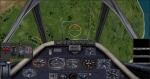
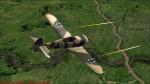
CFS2/FS2004 FW190A-C 2D Panel
(Category: CFS2 > Panels)
4.21Mb (510 downloads)
This is a modded panel from a download I had for years. I refined the bitmaps and rarranged the gauges to more acurately portray the FW190A-4 I've been working on.
Gauges are included from JWB,MAPE,and VW and stock. Watch for my FW190 on the payware downloads.
Posted Sep 3, 2011 00:54 by vincent farnham
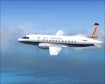
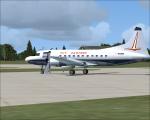
Eastern 1961 CV440 Textures
(Category: FS2004 > Vintage)
3.72Mb (606 downloads)
FS9/FSX Eastern 1961 "Silver Falcon" textures for Tom Gibson/ Greg Pepper Convair 440.
Textures by Gary Harper. These textures depict N9306 about 1961.
Note: Use in FSX will require a panel modification. Add a 2d FSX panel!
Required files:
required file
Posted Sep 3, 2011 00:32 by Gary Harper
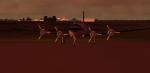
UPDATE-to "He went North to the Swamps" Mission
(Category: FSX > Missions)
0.05Mb (693 downloads)
This is an important Update to the Scenery and Texture directory of this Flight Adventure. You will not find Joe without them!!!
Required files:
required file
Posted Sep 3, 2011 00:24 by Gera Godoy Canova
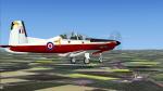
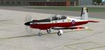
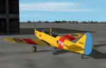
Iris Pilatus PC-9 - RAF Trainer Fictional Textures
(Category: FSX > Props)
4.65Mb (569 downloads)
Textures for the ex payware Iris Pilatus PC-9 - RAF TRAINER livery.
Fictional repaint by Dave Gore (fooflyer) using the IRIS PRO Series PC-9 paintkit by DAVID BRICE.
Required files:
required file
Posted Sep 2, 2011 10:01 by Dave Gore fooflyer
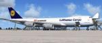
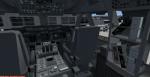
Boeing 747-823F Lufthansa Cargo with VC
(Category: FSX > Civil Jets)
28.45Mb (9406 downloads)
Boeing 747-823F Lufthansa Cargo. VC and other edits to make it work in FSX. Used edited version of the default B747-400 VC. Project Opensky Freighter 747-823F model. Opening cargo doors on nose and both sides with service vehicles. Opening Passenger (L1) door: Shift + E ( Opening door ) Opening Cargo Doors: Shift + E then quickly 2 Opening Passenger (L2) door: Shift + E then quickly 3 Opening Bulk Cargo Door: Shift + E then quickly 4. Lufthansa Cargo textures by Stefan Bree. FSX portover by Chris Evans.
Posted Sep 2, 2011 01:06 by Chris Evans
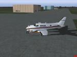
Beechcraft -C90B-Airborne-Critical-Care
(Category: FS2004 > Props)
6.10Mb (2218 downloads)
Airborne Critical Care was from Smithfield, NC located at KJNX. This business was a medical transport from about 2005 till 2007. Model by Dee Waldron. Panel by Michael Verlin. Textures by J.B. Barbour
Posted Sep 1, 2011 21:12 by J.B. Barbour
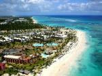

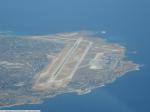
Punta Cana Airport, Dominican Republic Update
(Category: FS2004 > Scenery)
0.03Mb (4187 downloads)
Punta Cana Airport, Dominican Republic, with the new runway now included.
Posted Sep 1, 2011 17:45 by Alberto Thomas - Costa Rica
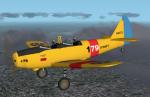
FS2004 US Navy PT-19 Textures
(Category: FS2004 > Vintage)
0.35Mb (467 downloads)
My idea of what a Fairchild PT-19 trainer might look like in US Navy colors based on Harm's Stearman from the TV show JAG. Textures only, you need Denis Da Silva's original PT-19 or my US version of it to use.
Required files:
required file
Posted Sep 1, 2011 13:29 by Don Brynelsen
Palermo Punta Raisi Intl Airport, Italy, Update
(Category: FSX > Scenery)
3.75Mb (3965 downloads)
Palermo Punta Raisi Intl Airport-Update. This is the update of the previous Palermo P.Raisi (previous version had 1678 downloads). The plan file is revised, and there are new custom objects
Posted Sep 1, 2011 11:29 by Skara Scenery
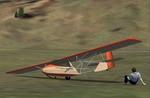
FS2004 Hol's Der Teufel Glider (updated)
(Category: FS2004 > Gliders and Ultralites)
0.26Mb (1257 downloads)
FS2004 Hol's Der Teufel Glider (updated)
A German training sailplane designed by Lippisch.
The plane served the first Hungarian Glider Club
MOVERO also in 1929 without instruments.
The start mode was " toy-catapult " .
FS model by Naoki Uehara.
Accurate flight dynamics, polar datas, repaint,
panel by George Csillag.
Posted Sep 1, 2011 08:59 by George Csillag