


All Files > Page 1901
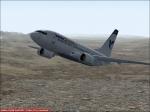
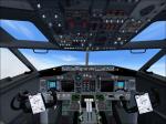
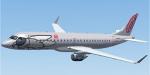
FS2004 Boeing 737-700 IranAir Textures only
(Category: FS2004 > Civil Jets)
3.40Mb (1508 downloads)
FS2004 Boeing 737-700 Iran Air Textures Only. Requires the 737 Experience v1.1 by Moach. Repaint by amin heyrani nobari.
Required files:
required file
Posted Sep 9, 2011 00:27 by amin heyrani nobari
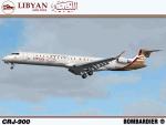
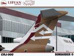
Libyan Arab Airlines NC, Bombardier CRJ-900 (5A-LAD)
(Category: FS2004 > Civil Jets)
11.96Mb (2809 downloads)
I am proud to present this CRJ-900 in the excellent Project Opensky CRJ-900 V3 model in the beautiful Libyan Arab Airlines livery. This airframe, bearing registration 5A-LAD, is one of 5 CRJ9's in the Libyan Arab fleet and occasionally makes flights between Tripoli International (HLLT) and London Heathrow (EGLL), attesting to the range capabilities of this narrow-body aircraft handling Libyan Arab's low volume international routes. This is a detailed repaint with custom textures. All logos including the Arabic rendition of "Libyan Arab Airlines" are hand painted. The repainted textures in this package are 32-bit with no mipmaps for best clarity and quality. This is a complete installation package; version 2008.1.1 of the Project Opensky CRJ-900 V3 model is included. A special thanks to Chris Conrad, a fellow simmer who inspired this project.
Posted Sep 8, 2011 14:54 by Jeffrey S. Bryner
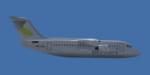
British Aerospace BAe146-200 Sky Work Airlines Textures
(Category: FSX > Civil Jets)
1.06Mb (489 downloads)
FSX/FS9 Sky Work Airlines British Aerospace BAe146-200. Textures only; requires the "Premier Aircraft Design BAe 146-200". Read the "ReadMe.txt" for further information. By Christopher Schenk.
Posted Sep 8, 2011 10:27 by Christopher Schenk
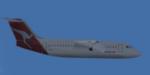
British Aerospace BAe146-200 Qantas Textures
(Category: FSX > Civil Jets)
1.09Mb (1200 downloads)
FSX/FS9 Qantas British Aerospace BAe146-200. Textures only; requires the "Premier Aircraft Design BAe 146-200". Read the "ReadMe.txt" for further information. By Christopher Schenk.
Posted Sep 8, 2011 10:27 by Christopher Schenk
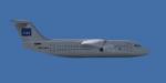
British Aerospace BAe146-200 Scandinavian Airlines Textures
(Category: FSX > Civil Jets)
1.06Mb (531 downloads)
FSX/FS9 Scandinavian Airlines British Aerospace BAe146-200. Textures only; requires the "Premier Aircraft Design BAe 146-200". Read the "ReadMe.txt" for further information. By Christopher Schenk.
Posted Sep 8, 2011 10:25 by Christopher Schenk
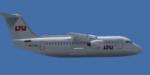
British Aerospace BAe146-200 LTU Textures
(Category: FSX > Civil Jets)
1.06Mb (344 downloads)
FSX/FS9 LTU British Aerospace BAe146-200. Textures only; requires the "Premier Aircraft Design BAe 146-200". Read the "ReadMe.txt" for further information. By Christopher Schenk.
Posted Sep 8, 2011 10:24 by Christopher Schenk

British Aerospace BAe146-200 Lufthansa Regional Textures
(Category: FSX > Civil Jets)
1.08Mb (2605 downloads)
FSX/FS9 Lufthansa Regional British Aerospace BAe146-200. Textures only; requires the "Premier Aircraft Design BAe 146-200". Read the "ReadMe.txt" for further information. By Christopher Schenk.
Posted Sep 8, 2011 10:23 by Christopher Schenk
Embraer ERJ-190 FlyNIKI Textures
(Category: FSX > Civil Jets)
0.98Mb (2035 downloads)
FSX/FS9 FlyNIKI Embraer ERJ-190, I-ADJM. Textures only; requires the "Premier Aircraft Design ERJ-190". Read the "ReadMe.txt" for further information. By Christopher Schenk.
Required files:
required file
Posted Sep 8, 2011 10:03 by Christopher Schenk
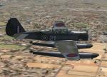
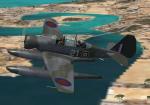
Northrop N3PB floatplane
(Category: FSX > Vintage)
4.99Mb (2010 downloads)
FSX/FS2004 Northrop N3PB floatplane
Northrop N-3PB of No. 330 (Norwegian) Squadron RAF. The Squadron was formed at Reykjavik on 25 April 1941 from Norwegian personnel, who had managed to escape from Norway and then undergone training in Canada. They initially flew with RAF Sunderland crews but in May they flew with the 24 aircraft ordered by the Norwegian government.GMAX mdl by A.F.Scrub.
Posted Sep 8, 2011 10:01 by A.F.Scrub
North American Airlines Callsigns
(Category: FSX > Misc)
0.00Mb (827 downloads)
Callsigns for airlines from North America and Canada.
Posted Sep 8, 2011 09:59 by eldar