


All Files > Page 2883
FS2004
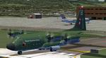
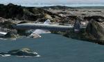
Lockheed C-130H Hercules Royal Nepalese Army (Air Service)
(Category: FS2004 > Military)
2.08Mb (7841 downloads)
FS2004
Lockheed C-130H Hercules Royal Nepalese Army (Air Service).
This model comes with the realistic C-130 panel & sounds and
is also setup for smoke trails. For FS2004 only. Painted By
Cristiano Magnani and Repainted by Praz Rimal. 2.1MB
Posted Aug 15, 2009 04:06 by archive
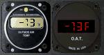
Elec Intl and UMA OAT
(Category: FS Gauges > FS Gauges)
0.17Mb (1187 downloads)
Two other stand alone XML digital OAT indicators for FS2004 and FSX. By Pierre Fasseaux
Posted Aug 15, 2009 04:04 by Pierre Fasseaux
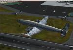
Connie PP-VDF VARIG Textures
(Category: FS2004 > Vintage)
4.41Mb (1167 downloads)
Textures of VARIG PP-VDF Lockheed Super G Constellation "Intercontinental" based on the original textures by Manfred Jahn.
It requires the great model package of the L-1049G Super Constellation with tip tanks.
Required files:
required file
Posted Aug 14, 2009 22:54 by Luiz Foernges
Connie PP-YSA T VARIG extures
(Category: FS2004 > Vintage)
3.88Mb (819 downloads)
This is repaint of the VARIG L-1049H/01-03-159 PP-YSA, s/n 4833, Lockheed Super H Constellation "Intercontinental" based on the original textures by Manfred Jahn.
It was originally a REAL Airlines aircraft. Later it was exported as N563E.
It requires the great model package of the L-1049H Super Constellation.
Required files:
required file
Posted Aug 14, 2009 22:49 by Luiz foernges
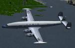
Connie PP-VDC VARIG Textures
(Category: FS2004 > Vintage)
4.12Mb (564 downloads)
This is a repaint of the VARIG PP-VDC Lockheed Super G Constellation based on the original textures by Manfred Jahn.
It requires the great model package of the L-1049G Super Constellation no tip tanks.
Required files:
required file
Posted Aug 14, 2009 22:44 by Luiz Foernges
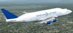
Boeing 747-400 Dreamlifter
(Category: FS2004 > Civil Jets)
9.04Mb (11474 downloads)
Boeing 747-400 Dreamlifter. Original model by Project Opensky.
Posted Aug 14, 2009 17:13 by repaintings masw
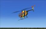
Hughes 500 Magnum PI Update/fix
(Category: FSX > Helicopters)
1.12Mb (3492 downloads)
This model was included in a fs2004 scenery pack. Fixed the the engine wouldn't run in free flight. Works in both fs2004 and fsx with (Bjorn Buchner's) great Hughes 500d helicopter and with the highly detailed Magnum PI scheme repaint by: Peter M. Ridge.
Posted Aug 14, 2009 16:26 by caleb blanzy /megagamer44
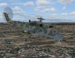
MI24V Hind
(Category: FSX > Helicopters)
33.02Mb (15245 downloads)
Mil Mi 24 V Full VC Cockpit By Tim Conrad Updated By Nor-Cal
Textures by Mike Pearson and Gregory Paul.
Posted Aug 14, 2009 15:14 by dominikx
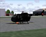
Bo-105 Swiss Civil Textures
(Category: FS2004 > Helicopters)
0.84Mb (572 downloads)
Bo-105 Swiss civil textures only for the Bo-105 by Guther Krame
Required files:
required file
Posted Aug 14, 2009 10:26 by benimix

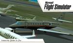
Cessna Citation Sovereign PR-SPR
(Category: FS2004 > Civil Jets)
9.88Mb (3206 downloads)
This is the Cessna Citation Sovereign of Alex Guedes ,registre PR-SPR, Texture By Gustavo La Cruz, Model and panel included. No VC.
Posted Aug 14, 2009 02:27 by Gustavo La Cruz