All Files > Page 4850

CFS Scenery Macros "German Planes
(Category: FS Design > Scenery Design Objects)
0.44Mb (215 downloads)
CFS
Scenery Macros "German Planes - API Macros" Version 1.0
for Combat Flight Simulator. This archive contains new additional
Static German Planes Macros for Airport 2.xx for creating
Scenery for Combat Flight Simulator, converted from freeware
fliyable versions. I am mainly included training, transport,
civilian and fighter planes, for different purpose of the
airports (civilian or military) created for the CFS1 flightsimmers.
. Edmundo Abad. 451K
Posted Jun 23, 2008 14:18 by archive

CFS Scenery Macros - Italian Planes Macros
(Category: FS Design > Scenery Design Objects)
0.89Mb (181 downloads)
CFS
Scenery Macros - Italian Planes Macros for Airport 2.xx
for creating Scenery for Combat Flight Simulator, converted
from fliyable versions of I Soliti Quattro Gatti crew.Version
2.0 for Combat Flight Simulator. This archive contains new
additional Static Italian Planes Macros for Airport 2.xx for
creating Scenery for Combat Flight Simulator, converted from
fliyable versions of I Soliti Quattro Gatti crew. Edmundo
Abad. 917K
Posted Jun 23, 2008 14:18 by archive

FS2000-2002 Static airport API macros. Thatched buildings set
(Category: FS Design > Scenery Design Objects)
0.38Mb (474 downloads)
FS2000-2002
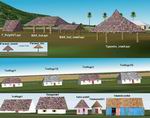
Static airport API macros. Thatched buildings set,19
apis.A set of parasols, gazebos, stilt houses, water villas,
irish cottages, cuban houses and more thatched-roof structures.
Suitable for many parts of the world. For scenery designers
only. by Jorge Pagano. 389K
Posted Jun 23, 2008 14:18 by archive

Airport Building with Tower API Macro.
(Category: FS Design > Scenery Design Objects)
0.20Mb (764 downloads)
Airport
Building with Tower API Macro.
for Flight Simulator Scenery Design. For use with any design
program that uses 'API' files for scenery objects. Damian
Siman. 208K
Posted Jun 23, 2008 14:18 by archive

FS2004 Rubber tired construction crane complete with night textures.
(Category: FS Design > Scenery Design Objects)
0.30Mb (379 downloads)
FS2004
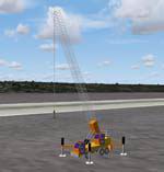
Rubber tired construction crane complete with night textures.
API macro This API was made using NovaSim by Rafael Garcia
Sanches. I have used it with Airport 3.0 build 192 to make
scenery and test this API file .For scenery designers only.
By Scott Hendrix. 310K
Posted Jun 23, 2008 14:18 by archive

FS2004 House with night textures API macro
(Category: FS Design > Scenery Design Objects)
1.67Mb (547 downloads)
FS2004
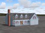
House with night textures API macro This
is just a nice little house with an attached garage, complete
with night textures. This API was made using NovaSim by Rafael
Garcia Sanches. I have used it with Airport 3.0 build 192
to make scenery and test it. By Scott Hendrix 1.65MB
Posted Jun 23, 2008 14:18 by archive

FS2004 Three construction cranes API macros
(Category: FS Design > Scenery Design Objects)
0.64Mb (490 downloads)
FS2004
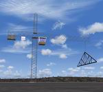
Three construction cranes API macros Three
construction cranes, one that is stationary, one that turns
and one that turns with a roof truss on the hook. They all
have night textures and lights. They where made using NovaSim
by Rafael Garcia Sanches. I have used it with Airport 3.0
build 192 to make scenery and test them. By Scott Hendrix
554KB
Posted Jun 23, 2008 14:18 by archive
FS2002/2004 Small Bridge API.
(Category: FS Design > Scenery Design Objects)
0.16Mb (169 downloads)
FS2002/2004
Small Bridge API.
An API with a small bridge. (copy is authorized only between
FS users, modification are prohibited). API by Gaël LE BRIS
- Distributed by COGITO. 161K
Posted Jun 23, 2008 14:18 by archive
FS2002/2004 Small Office Building API.
(Category: FS Design > Scenery Design Objects)
0.02Mb (267 downloads)
FS2002/2004
Small Office Building API. An
API with a small building. (copy is authorized only between
FS users, modification are prohibited). API by Gaël LE BRIS
- Distributed by COGITO. 21K
Posted Jun 23, 2008 14:18 by archive
FS2002/2004 Lighthouse API
(Category: FS Design > Scenery Design Objects)
0.26Mb (247 downloads)
FS2002/2004
Lighthouse API.
An API with a lighthouse (Treizien, Brittany-Fr). (copy is
authorized only between FS users, modification are prohibited).
API by Gaël LE BRIS - Distributed by COGITO. 271 K
Posted Jun 23, 2008 14:18 by archive


