


All Files > Page 521
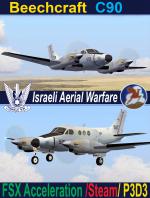

FSX/Steam/P3D3 IAF Beech C90 Upgraded.
(Category: FSX > Military)
56.43Mb (3531 downloads)
FSX/Steam/P3D3 IAF Beechcraft C90. This is an upgraded photoreal livery with completely new flying dynamics, new 2D panels and revised interior/exterior textures. Israeli Aerial Warfare Part of IAF used several aircraft of the King Air C90 and C200 series. There are two precision photoreal 2d panels. The V.C.imitation and the High Visibility. They include custom gauges,2 Diferent types of GPS an imitation weather radar and my new moving 2D yokes. There is no V.C. but I think you will be more than satisfied with the 2D V.C.imitation. There are 2 liveries of mate and gloss finish.If you want to use the model as an AI (traffic) there is a seperate AI configuration file included. Textures are in DXT 2048 px.format for clarity. Model by Henry Tomkiewicz & Dee Waldron. All upgrades done by Yiannis Katehis Tsetsas 2019.
Posted Oct 10, 2019 15:04 by Yiannis Katehis Tsetsas
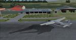
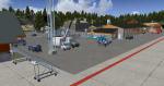
FSX/FSX-SE KSNY Sidney Nebraska USA
(Category: FSX > Scenery)
1.23Mb (259 downloads)
FSX/FSX-SE Scenery--KSNY Sidney Nebraska USA. The scenery is my redesign of the KSNY default airport file at Sidney, NE. At the airport I added some new and additional buildings, static vehicles and aircraft and more parking. The default airport lacked static vehicles, and some additional parking. Sidney is the home of the original Cabela's Outdoor stores and its headquarters prior to being purchased by Bass Pro Shops. Sidney sits on I-80 in western Nebraska and is not too far from Cheyenne, Wy and Denver, CO. I added some representation of the type of business that are at the I-80 interchange where you exit to go to the Cabela's store. To the south I added some business, hospital, and elevators along with warehouses. I put some static trains in the same area to represent the coal and tank car train traffic common to the area. When you fly around the area, I think you will enjoy the added scenery objects that liven up the area. By Dick Mohatt.
Posted Oct 10, 2019 08:48 by uploader
.jpg-thumb.jpg)
.jpg-thumb.jpg)
FSX/Accel//P3dv3 Two Pilotable Full-Rigged Tallships
(Category: FSX > Misc)
11.46Mb (546 downloads)
FSX/Accel//P3dv3 Pilotable full-rigged tallships Danmark and Sorlandet. This are traditional sail training vessels from the thirtees. Both beautyful ladies are still in service sailing with a little main crew and about eighty trainees. Both ai-ships are made by Henrik Nielsen and belongs to his huge ai-fleet traffic package "Global_AI_Ship_Traffic_V2.zip" which contains almost 1100 AI ships and AI ship traffic routes for the entire globe for P3D and FSX. This pilotable versions has a 2D panel, virtual decks and mast views, alltogether about twenty cameras which let you explore the detailed ship. The modifications for a pilotable boat and the camera and effect configuration is made by Erwin Welker
Required files:
required file
Posted Oct 9, 2019 04:09 by Erwin Welker
P3D/FSX ENFG_Fagernes/Leirin, Norway BUGFIX for P3DV4 and FSX
(Category: Prepar3d > Scenery)
14.92Mb (211 downloads)
This is just a bugfix for my ENFG scenery wich eliminates an issue with crashing on the apron if the crash detection is activated. This bugfix works in FSX and P3DV4.
Required files:
required file
Posted Oct 9, 2019 02:11 by Wolfgang Allers
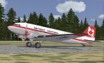
FSX/P3D Northwest Territorial Airways DC-3 textures
(Category: FSX > Vintage)
42.75Mb (242 downloads)
FSX/P3D Northwest Territorial Airways DC-3 textures for Manfred Jahn and team C-47 v3.12.
Northwest Territorial Airways textures by Gary Harper.
Required files:
required file
Posted Oct 8, 2019 21:55 by Gary Harper
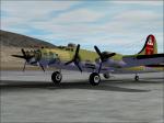
B-17 Flying Fortress Nine-0-Nine Memorial Download
(Category: FS2004 > Vintage)
11.41Mb (1767 downloads)
In memory of the fatal crash of Nine-0-Nine I repainted the B-17 giving FULL credit to the aircraft designer/creator. Model by Alphasim.
I added a black stripe on the right wing next to the "A" logo, includes stripe under wing as well.
I also added a memorial with 7 lit candles on the right side front fuselage representing the 7 lives lost on that horrific day, includes the date.
RIP 9-0-9 and thank you for serving our country for so many years. May all rest in eternal peace
Posted Oct 8, 2019 10:05 by Georgette Kostopoulos

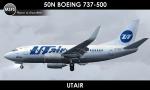
50 North Boeing 737-500 Utair Textures
(Category: FSX > Payware)
10.66Mb (108 downloads)
Textures for the payware FS9/FSX 50North Boeing 737-500 in UTair Aviation old colors livery. Repaint by Sergey Gleba. Paint Kit by Denis Minaev. Link to my products on SimMarket: http://secure.simmarket.com/paintsim.mhtml
Posted Oct 8, 2019 02:16 by Sergey Gleba aka serg09
Photorealistic Arusha Airport, Tanzania
(Category: FSX > Scenery)
100.81Mb (474 downloads)
[2019] Arusha Airport Tanzania newest scenery upgraded from stock version.
Posted Oct 6, 2019 04:18 by Peter Mbirima
P3D/FSX ENFG_Fagernes/Leirin, Norway for P3DV4
(Category: Prepar3d > Scenery)
245.14Mb (548 downloads)
The airport ENFG is situated about 4 kilometers northeast of the city of Fagernes in the municipal of Nord-Aurdal, Oppland, about 120 miles northeast from Oslo. The altitude of ENFG is 822 m / 2,697 ft. The airport is very close to the imposant rocks of Jutunheimen.
The senery has a photo background that covers all four seasons: spring, summer, autumn and winter. The surroundings are made via new landclasses which fit mostly the reality. Also all lakes and rivers are updated.
The buildings in this scenery are mostly taken from the fantastic XPlane scenery made by Hans Kristian Braaten Olsen, who kindly gave me permission to use his buildings in this scenery. I prepared them for FSX and partly reworked them a bit.
Posted Oct 6, 2019 02:49 by Wolfgang Allers
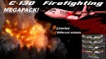
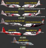
P3D/FSX C-130 Aerial Firefighting Repaint Megapack
(Category: Prepar3d > Military)
21.40Mb (1105 downloads)
This package was repainted for either the stock P3D CaptainSim C-130s or the payware C-130X package for FSX/P3D aircraft. The pack includes nearly all operator liveries to fly the C-130 in aerial firefighting missions in the USA and Australia in the last 5 years. This repaint package includes 9 liveries and covers 2 different visual models. Mainly the C-130H or Model.C-130H and the L-100-30 (382G) or Model.12 in the aircraft.cfgs. The pack includes repaints for Coulson Group's T-131 in US livery(2019), T-390 (T-131 essentially just renumbered for Australia) in Emergency Management Victoria, Australia (2018). Now former Coulson T-132 in US livery and New South Wales RFS, Australia. Coulson T-134 in it's brief bare metal or, "rat rod" livery, as well as it's current livery (2019). Now ex-USFS T-116. Soon to be active CAL FIRE T-118. Lastly, USAF MAFFS 9 of the 152nd AW Nevada Air National Guard. If you do not have the C-130X pack in P3D all aircraft except T-132 will be able to show up in the Sim, CS' C-130X is however, entirely required for FSX users. Repaints by: Nicholas Mitchell
Posted Oct 4, 2019 21:14 by Nicholas Mitchell