


All Files > Page 1689

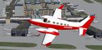
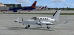
FSX Cessna 414A Chancellor red and white N4869R Textures
(Category: FSX > Props)
2.06Mb (1048 downloads)
An FSX red and white N4869R repaint texture for the Premier Aircraft Design
Cessna 414A Chancellor, which you must have previously installed in FSX.
Easy installation, screenshots enclosed. Repaint by Tom Tiedman.
Required files:
required file
Posted May 31, 2012 04:45 by Tom Tiedman
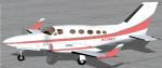
FSX Cessna 414A Chancellor pink, gray, and white N3768T Textures
(Category: FSX > Props)
1.70Mb (341 downloads)
An FSX pink, gray, and white N3768T repaint texture for the Premier Aircraft Design
Cessna 414A Chancellor, which you must have previously installed in FSX.
Easy installation, screenshots enclosed. Repaint by Tom Tiedman.
Required files:
required file
Posted May 31, 2012 04:42 by Tom Tiedman

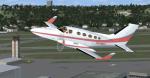
FSX Cessna 414A Chancellor green and white N7435Y Textures
(Category: FSX > Props)
1.54Mb (612 downloads)
An FSX green and white N7435Y repaint texture for the Premier Aircraft Design
Cessna 414A Chancellor, which you must have previously installed in FSX.
Easy installation, screenshots enclosed. Repaint by Tom Tiedman.
Required files:
required file
Posted May 31, 2012 04:40 by Tom Tiedman


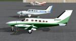
FSX Cessna 414A Chancellor red and white N7692J Texture
(Category: FSX > Props)
1.47Mb (534 downloads)
An FSX red and white N7692J repaint texture for the Premier Aircraft Design
Cessna 414A Chancellor, which you must have previously installed in FSX.
Easy installation, screenshots enclosed. Repaint by Tom Tiedman.
Required files:
required file
Posted May 31, 2012 04:38 by Tom Tiedman

FSX Cessna 414A Chancellor blank white Textures
(Category: FSX > Props)
1.50Mb (449 downloads)
An FSX blank white paintable repaint texture for the Premier Aircraft Design
Cessna 414A Chancellor, which you must have previously installed in FSX.
Easy installation, screenshots enclosed. Repaint by Tom Tiedman.
Required files:
required file
Posted May 31, 2012 04:34 by Tom Tiedman
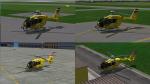
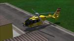
EC-135 OAMTC Texture Pack
(Category: FS2004 > Helicopters)
92.71Mb (604 downloads)
ÖAMTC texture-pack for the Icaro EC-135 package.
Required files:
required file
Posted May 30, 2012 20:20 by benimix - Benedikt Fröhlich


Jungle Merchant...Jungle Flying DeLuxe
(Category: FSX > Missions)
7.32Mb (2165 downloads)
"Dear Sir...You have inherited the one aircraft "Amazonas Air Freight Airways" from your ex Air Force buddy Siverton Ecceter or "Chewing gum Gogo", he flew over the hotizon yesterday after getting drenched in the "Mother of all Thunderstorms" as some heavy rain showers are known here in Bolivia. You get a Beechcraft 99 with a big pod in the fuselage underside. You also get his "Merchant Route" which is valid for one more year. His widow, Iliana, is waiting for you in their home base airport in Tarija. She will be your manager so all you will have to do is fly the turbo and pay off the bank before they get it!!!..Iliana will be your secretary and show you around, she is only 29 years old but sure knows the airline and its clients very well, so it should be a piece of cake for you....You lucky dog!!!!"...Yours Truly: Efrarin Mocoso; Barrister, Lawyer et All.....
Posted May 30, 2012 16:46 by Gera Godoy Canova

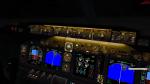
Boeing 737-800 Gauge - Black Background v 4
(Category: FSX > Panels)
2.62Mb (3365 downloads)
This is the default FSX Boeing 737-800 gauge recolored to give a black background instead of blue on the instrument screens. Backup your original gauge and simply place this gauge inside the panel folder of your 737 using the default B737_800.CAB.
Posted May 30, 2012 14:04 by kraleks
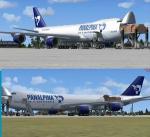
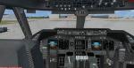
Boeing 747-8F Panalpina Atlas Air Package
(Category: FSX > Civil Jets)
30.03Mb (3885 downloads)
Project Opensky - Boeing 747-8F Panalpina (Atlas Air) N850GT. Atlas Air Cargo has
placed two new Boeing 747-8 freighter aircraft with Swiss freight consolidator
Panalpina Air.
Added the Posky native FSX Boeing 747-8 cargo model. Updated with the default B747 VC
and 2d panel.
VC and other edits to make it work in FSX. Used edited version of the default B747-400
VC. Project Opensky Freighter 747-823F model. Opening cargo doors. Includes ground
services (Views - Instrument Panel - Posky Utilities). Panalpina textures by unknown.
FSX portover by Chris Evans.
Posted May 30, 2012 11:36 by Chris Evans
L.A./Ontario Intl. Airport, California, Upgrade
(Category: FSX > Scenery)
0.09Mb (669 downloads)
L.A./Ontario Intl Airport in California. Includes the T1, T2, 3, T4 terminals, plus the Fedex, and UPS aprons, runways, and all taxiways aligned to the MSE photoreal base. Includes a version for use with MegaSceneryX - Southern California.
Posted May 30, 2012 00:01 by Jim Hill