


All Files > Page 4316
FS2004
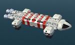
"Starship Enterprise" Upgraded
(Category: FS2004 > Misc)
1.98Mb (10636 downloads)
FS2004
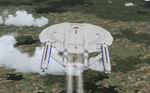
"Starship Enterprise" Upgraded This
upgrade adds nav lights, glowing engine and main body parts
to look more like the TV Enterprise. This is the latest in the
line of federation starships. The first starship capable of
reaching warp 5. From the TV series Enterprise, Captained by
J. Archer. This is the first in line of many Star Trec fame
spacecraft that I will be making.Model by Chris Herring built
in FSDS v3. 2.2MB
Posted Jun 23, 2008 14:27 by archive
FS2004
BMW 760 LI.
(Category: FS2004 > Misc)
1.20Mb (15049 downloads)
FS2004
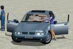
BMW 760 LI.
Includes fuinctional interior, opening doors. By Mitsuya Hamaguchi.
1.2MB
Posted Jun 23, 2008 14:27 by archive
FS2004
Nissan Skyline Beta
(Category: FS2004 > Misc)
23.42Mb (3757 downloads)
FS2004
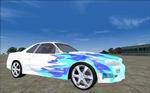
Nissan Skyline Beta
This is a test version of the full package that will be released
in either late August or early September of 2006. It is intended
to bring feedback regarding almost all aspects of the Nissan's
dynamics. Further information will be on the "Read Me" file
enclosed within the beta. Jessy Corrales. 24MB
Posted Jun 23, 2008 14:27 by archive

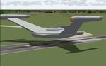
FS2004
"USS Voyager NCC 74656"
(Category: FS2004 > Misc)
1.78Mb (8132 downloads)
FS2004
"USS Voyager NCC 74656" This
model contains animated wings, they raise and lower just like
the TV version. The animated shuttle bay door will reveal a
shuttle inside ready for departure. Built in FSDS By Chris Herring.
1.8MB
Posted Jun 23, 2008 14:27 by archive
FS2004
Ultra Realistic Envmap File - Metalic Reflections Mod.
(Category: FS2004 > Misc)
0.14Mb (4632 downloads)
FS2004
Ultra Realistic Envmap File - Metalic Reflections Mod.
This a new remake of my old envmap file for fs2004 which is
probably the most realistic one on the net. It was made with
the aid of an actual photo of a landscape and then edited with
Photoshop the result? a highly realistic envmap file which shows
every detail of the sky being reflected on mettalic surfaces
right down to the clouds. Pedro Padilla. 143K
Posted Jun 23, 2008 14:27 by archive
FS2004
"Romulan Bird of Prey"
(Category: FS2004 > Misc)
1.48Mb (3526 downloads)
FS2004
"Romulan Bird of Prey"
. The Romulan Battle Cruiser Bird of prey. Model by Chris Herring
built in FSDS v3. 1.5MB
Posted Jun 23, 2008 14:27 by archive
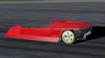
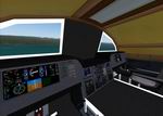
FS2004/2002
X1F Endeavor Jet Turbine Powered Concept Car.
(Category: FS2004 > Misc)
5.69Mb (4798 downloads)
FS2004/2002
X1F Endeavor Jet Turbine Powered Concept Car.
Features opening doors, opening engine compartment, turbine
jet engine, Virtual Cockpit, animated features, reflective and
shine textures, and illuminated VC instrumentation. This is
a fun little vehicle that can take you about the scenery of
Flight Simulator with a bit of pizzaz! If you like exotic, sleek
cars and you dont want to haul your entire aircraft down main
street of Las Vegas to watch the fire works, then you might
want one of these. This is created from an actual concept car.
Config file by Bill and Lynn Lyons. Vehicle done in Gmax. By
William Ortis, Lionheart Creations Ltd. 5.8MB
Posted Jun 23, 2008 14:27 by archive
FS2004
Hovercraft SRN
(Category: FS2004 > Misc)
1.48Mb (9591 downloads)
FS2004
Hovercraft SRN.
The hull goes up and down by the engine a start a stop. Mitsuya
Hamaguchi. 1.5MB
Posted Jun 23, 2008 14:27 by archive
FS2004
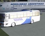
Aerolineas Argentinas/Austral Official Bus transport
(Category: FS2004 > Misc)
0.79Mb (6948 downloads)
FS2004
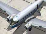
Aerolineas Argentinas/Austral Official Bus transport.
: Aerolineas Argentinas/Austral Hama´s busv3 transport, texture´s
only. Aerolineas Argentinas have some of this bus to transport
the passengers of his flights between the gate and the aircraft.
Model and flight dinamycs by Mitsuya Hamaguchi, repainted by
Alfredo José Gelmini. 808K
Posted Jun 23, 2008 14:27 by archive
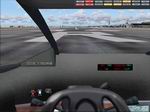
FS2004
Eagle
(Category: FS2004 > Misc)
13.01Mb (6881 downloads)
FS2004
Eagle The
Eagle is an aircraft taken from the TV-series "Space 1999".
The Eagle has VSTOL capabilities. It can take of and land at
speeds of 25-35 kias! The flight charact- eristics are nearly
helicopter-like at low speeds and 100% plane-like at speeds
above ~120 kias. FS2004, dynamic virtual cockpit, 5 versions,
opening doors, pod can be lowered, moving parts, panel with
custom gauges, custom sound, please read the flight manual!
by Eugene Heyart. 13.3MB
Posted Jun 23, 2008 14:27 by archive