


All Files > Page 4967
FSX
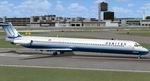
MD81 Add-on Textures pack
(Category: FSX > Civil Jets)
26.50Mb (8204 downloads)
FSX
MD81 Add-on Textures pack.
Here are some add ons for the MD81 SAS Package V1 (above). Included
the aircraft config so all you have to do is place my aircraft.cfg
with the 1 that came with the SAS package. This will give you
: Delta, United, Us Air, American, Maridiana & Aerlinas
Argentinas. Fred Miller. 27MB
Posted Jun 23, 2008 14:17 by archive
FSX
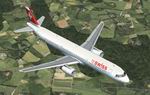
Airbus A321 Swiss Textures only
(Category: FSX > Civil Jets)
3.19Mb (5630 downloads)
FSX
Airbus A321 Swiss Textures only.
Repaint for the FSX default Airbus A321 in colors of the "Swiss
International Airline". Created by Dominik Annen. 3.2MB
Posted Jun 23, 2008 14:17 by archive
FSX
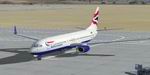
Boeing 737-800 British Airways Textures only
(Category: FSX > Civil Jets)
3.08Mb (9811 downloads)
FSX
Boeing 737-800 British Airways Textures only.
Repaint for the FSX default Boeing 737-800 in colors of the
"British Airways". 3.1MB
Posted Jun 23, 2008 14:17 by archive
FSX
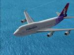
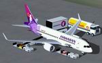
Boeing 747-400 Hawaiian Textures only
(Category: FSX > Civil Jets)
1.85Mb (3331 downloads)
FSX
Boeing 747-400 Hawaiian Textures only.
For the default FSX 747. Created by Ichiro Yamamoto. 1.9MBK
Posted Jun 23, 2008 14:17 by archive
FSX
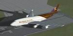
Boeing 747-400 UPS Textures only
(Category: FSX > Civil Jets)
0.66Mb (6377 downloads)
FSX
Boeing 747-400 UPS Textures only.
For the default FSX 747. Created by Ruiqi Chen. 681K
Posted Jun 23, 2008 14:17 by archive
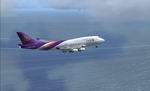
FSX
Default Boeing 747-400 Thai livery Textures
(Category: FSX > Civil Jets)
3.02Mb (5104 downloads)
FSX
Default Boeing 747-400 Thai livery Textures
: Hariphunchai HS-TGJ Livery, including hires Night textures.
Repaint by: Jathedar. 3.1MB
Posted Jun 23, 2008 14:17 by archive
FSX
Boeing 707-120 Package
(Category: FSX > Civil Jets)
36.21Mb (16313 downloads)
FSX
Boeing 707-120 Package. This is HJG'S FS2004 HJG Boeing
707-120 v6 converted to FSX. The aircraft.cfg has been totally
redone as has the .air file. Smoke has been redone to match
each engine. For those of you who have Shockwave's 3D landing
lights you will also have them here. There are eight liveries
in this package and each one is beautiful. The nav lights have
been redone to be more realistic. Package by David Grindele.
37MB
Posted Jun 23, 2008 14:17 by archive
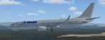
FSX
Boeing 737-800 Air Slovakia textures only
(Category: FSX > Civil Jets)
1.12Mb (1036 downloads)
FSX
Boeing 737-800 Air Slovakia textures only
for the default 838-800. 1.1MB
Posted Jun 23, 2008 14:17 by archive
FSX
Bombardier CSeries 110 Hawaiian Airlines
(Category: FSX > Civil Jets)
1.54Mb (4180 downloads)
FSX
Bombardier CSeries 110 Hawaiian Airlines
standard version and optional LR version, including a new Animated
Ground Servicing (AGS). Model design and paint by: Camil Valiquette.
1.6MB
Posted Jun 23, 2008 14:17 by archive
FSX
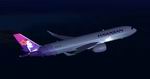
Airbus A350-800 XWB Hawaiian Airlines
(Category: FSX > Civil Jets)
1.42Mb (3364 downloads)
FSX
Airbus A350-800 XWB Hawaiian Airlines
, including a new Animated Ground Servicing (AGS). Model design
and paint by: Camil Valiquette. 1.4MB
Posted Jun 23, 2008 14:17 by archive