


All Files > Page 1293
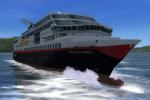
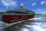
FSX Quadruplepack Pilotable Hurtigruten Ships Package
(Category: FSX > Misc)
14.12Mb (2645 downloads)
FSX Quadruple pack pilotable Hurtigruten ships. Hurtigruten is the famous Norwegian postal, passenger and ferry coastal line. It was, and sometime it is until now, the only infrastructure for some remote villages along the long coast of Norway. The package consists of the modern liners Trollfjord and Midnatsol and the ferries Stavangerfjord and Bergensfjord. This pretty FS-modells with night lighting are made by Henrik Nielsen and belongs to his addon "130 AI Ships and AI Ship Traffic.zip", which brings traffic into harbors and empty sea. The pilotable versions provides a 2D-panel with photorealistical navigation bridge, sounds and ship effects. Seven camera views let you explore the decks. Features for pilotable versions with navigation bridge as panel and added views by Erwin Welker
Posted Apr 16, 2014 03:37 by Erwin Welker
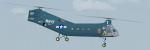
Piasecki H-21/HRP-2 Updated Package
(Category: FSX > Helicopters)
12.43Mb (3018 downloads)
This is an update to the Mick Posch FS2004 USAF Piasecki H-21C Helicopter. The 2D panel has been re-gauged for FSX using a photo of an actual H-21 instrument panel. This package includes ten (four Air Force, three Army, and three Navy) textures, with thumbnails, by various authors. 2D panel only, no VC panel.
Posted Apr 15, 2014 19:53 by Michael E. Roberts
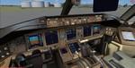
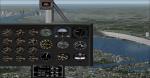
P3d v3 VC window textures patch for the FSX Project Opensky/Skyspirit Boeing 777 series
(Category: Prepar3d > Civil Jets)
4.42Mb (3960 downloads)
P3d v3 VC window textures patch for the FSX Project Opensky/Skyspirit Boeing 777 series.
This will fix the opaque windows if using the FSX Boeing 777-300 or 200 series from Project Opensky or Skyspirit in Prepared 3D v3. (also OK in FSX) (not P3D v4)
Required files:
required file
Posted Apr 15, 2014 04:35 by Pete Daly
LFEB Trelivan, France
(Category: FSX > Scenery)
37.78Mb (1414 downloads)
Dinan - Trelivan Airfield (ICAO: LFEB) is an aerodrome civil, open to public air traffic (CAP), located in the commune of Trelivan 3 km West-South-West of Dinan, in the Cotes-d'Armor.(22) France.
It is used for the practice of leisure and tourism (light aviation and aeromodelling) activities.
For FSX Acceleration only.
Posted Apr 15, 2014 04:29 by Viggenas Marcus

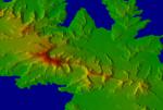
10M Mesh for Guadalupe Island
(Category: FSX > Terrain Mesh)
0.31Mb (625 downloads)
10M mesh for Guadalupe Island or Isla Guadalupe - a volcanic island located 241 kilometres (150 mi) off the west coast of Mexico's Baja California peninsula and some 400 kilometres (250 mi) southwest of the city of Ensenada in Baja California state, in the Pacific Ocean.
http://www.youtube.com/juan30005
http://www.facebook.com/FSXFULL
Required files:
required file
Posted Apr 14, 2014 22:32 by juan30005

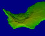
10M Mesh for South Georgia and the South Sandwich Islands
(Category: FSX > Terrain Mesh)
1.06Mb (521 downloads)
FSX 10M Mesh for "Isla Georgia del Sur"
South Georgia and the South Sandwich Islands (SGSSI) is a British overseas territory in the southern Atlantic Ocean. It is a remote and inhospitable collection of islands, consisting of South Georgia and a chain of smaller islands, known as the South Sandwich Islands.
http://www.youtube.com/juan30005
http://www.facebook.com/FSXFULL
Posted Apr 14, 2014 18:48 by juan30005
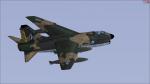
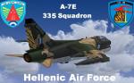
FSX Razbam A-7E HAF 335 Squadron 159645 Textures
(Category: FSX > Payware)
21.20Mb (662 downloads)
This is an extra texture addon for the payware Razbam A-7E and A-7D Corsair II model,containing
the Hellenic Air Force's A-7E of the 335 Squadron "Tiger" with a tiger painted scheme rudder.
Posted Apr 14, 2014 06:13 by Theofilos HAF
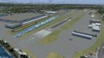
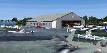
KRNT- Renton Municipal Airport, Seattle, V1
(Category: FSX > Scenery)
13.56Mb (1291 downloads)
This is a redo of KRNT located in the Seattle, Washington Area. KRNT is a major general aviation service airport, and also serves as the roll off point for new 737 aircraft from the Boeing plant located on the east side of the field. Lots of eye candy to make this airport a lot more interesting to fly into with small GA aircraft. NOTE! WILL NOT WORK WITH AI TRAFFIC!
Prepared with ADEx using FSX SP2.
Posted Apr 13, 2014 21:48 by Mike Pare
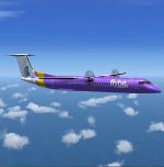

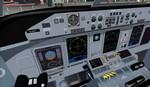
Flybe Bombardier DHC8-Q400
(Category: FSX > Props)
21.36Mb (13894 downloads)
This aircraft is another success story for Bombardier, it is well liked by airlines and passengers and with 480 orders so far it is the most successful variant of the Dash-8. On short haul routes the the Q400 combines the gate to gate journey times of a jet with the lower operating costs of a turboprop. 75 seat advanced twin turbo-prop regional airliner. Revised model (April 2014) with full moving parts, doors with airstair and animated pilots. Accurate and pleasant flight dynamics. Fully modelled interior. Full documentation including manuals and check/ref lists. Custom 'glass cockpit' and VC with digital gauges, custom sounds. Complete package for FSX. This model is painted in the new (2014) livery of Flybe who operate more Q400's than any other airline.
By Jean-Pierre Brisard and Bob May - Premier Aircraft Design.
Posted Apr 13, 2014 04:08 by Bob May (PAD)

Flybe Bombardier DHC8-Q400
(Category: FS2004 > Props)
21.20Mb (4059 downloads)
This aircraft is another success story for Bombardier, it is well liked by airlines and passengers and with 480 orders so far it is the most successful variant of the Dash-8. On short haul routes the the Q400 combines the gate to gate journey times of a jet with the lower operating costs of a turboprop. 75 seat advanced twin turbo-prop regional airliner. Revised model with full moving parts, doors with airstair and animated pilots. Accurate and pleasant flight dynamics. Fully modelled interior. Full documentation including manuals and check/ref lists. Custom 'glass cockpit' and VC with digital gauges, custom sounds. Complete package for FS2004. This model is painted in the new (2014) livery of Flybe who operate more Q400's than any other airline.
By Jean-Pierre Brisard and Bob May - Premier Aircraft Design.
Posted Apr 13, 2014 04:03 by Bob May (PAD)