


All Files > Page 1345
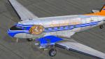
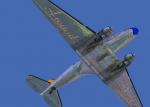
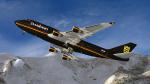
FSX Douglas C-47 Skytrain V2, Around the World Textures
(Category: FSX > Vintage)
51.14Mb (734 downloads)
FSX textures only "Around The World" Pack, three texture paints for FSX Douglas C-47 Skytrain V2. included personalized virtual cockpit paint. Repaint by Hani Michal.
Required files:
required file
Posted Dec 26, 2013 19:16 by Hani Michal
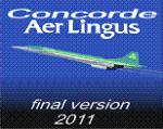
FS9/FSX Concorde Aer Lingus Textures
(Category: FSX > Civil Jets)
7.91Mb (1863 downloads)
This file contains only Aer Lingus texture for the FS9/FSX Concorde Final Version-A-2011 Updated version.
Requires CF2011A-2.zip. By Libardo Guzman.
Required files:
required file
Posted Dec 26, 2013 14:00 by archive
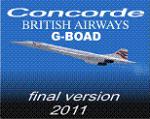
FS9/FSX Concorde British Airways G-BOAD Textures
(Category: FSX > Civil Jets)
8.09Mb (3932 downloads)
This file contains only British G-BOAD texture for the FS9/FSX Concorde Final Version-A-2011 Updated version. Requires CF2011A-2.zip.. By Libardo Guzman.
Required files:
required file
Posted Dec 26, 2013 13:57 by archive
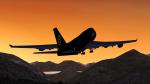
Swabian Airlines (fictional) Boeing 747-400 Textures
(Category: FSX > Civil Jets)
7.06Mb (488 downloads)
Swabian Airlines (fictional) textures for the default FSX Boeing 747.
Posted Dec 26, 2013 11:04 by Nils N.
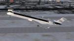
Air Transport Germany (fictional) CRJ700 Textures
(Category: FSX > Civil Jets)
7.36Mb (304 downloads)
ATG fictional) textures for the default FSX CRJ700.
Posted Dec 26, 2013 10:57 by Nils N.
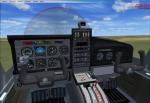
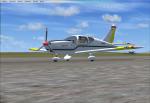
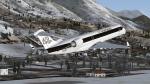
Tobago TB-10 TPI Curug Flying School Textures
(Category: FSX > Props)
0.76Mb (406 downloads)
Updates for Premier Aircraft Design Tobago TB-10 STPI Curug Flying School livery. Added Red color on the propeller. And also gray color for the VC texture as Tobago TB-10 STPI Curug Flying School livery in
the real world. Repaint by Tubagus Hardika.
Required files:
required file
Posted Dec 26, 2013 08:21 by Gizz
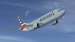
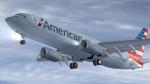
American Airlines New Logo texture for FSX B737-800
(Category: FSX > Civil Jets)
13.50Mb (4283 downloads)
American Airlines new logo had a mixed reception, some hating it with others loving it. Gone is the mirror shine fuselage replaced with a grey - military 'flat'paint finish. This is a High Definition 'texture only' repaint for the FSX default B737-800. To fly in Hi Def follow the simple instructions included in the download.
Posted Dec 26, 2013 02:10 by Paul Davies
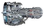
Airbus A320 Family IAE V2500
(Category: FS Sounds > Flight Simulator Sounds)
140.34Mb (8030 downloads)
SkyHigh Audio Simulations is proud to present our brand new Airbus A320 Family IAE V2500 sound pack for FSX! This add-on features configurations for three interior POV options such as cockpit, front cabin, and rear cabin. FSX's sound cone technology has been extensively used to provide as much of a realistic sound experience as possible in the exterior view. The A320 aircraft family's famous Pneumatic Transfer Unit 'barking' noise has been implemented in the start up sound, gear up sound, and engine shut down sound. Along with these features, SkyHigh Audio Simulations' usual touches have been added such as using audio recordings only from A320 IAE aircraft as source files to provide a fully authentic sound experience for the simmer.
Posted Dec 25, 2013 17:53 by Adam Murphy

Abacus AH-1G Cobra C/2/20 ARA, Early 1971 Textures
(Category: FS2004 > Payware)
3.04Mb (119 downloads)
Textures only for the payware Abacus Premier Collection AH-1G Cobra gunship. Sounds of Silence 68-17504 was an AH-1G that flew with C/2/20 ARA, Early 1971.
Textures only By Lloyd Snake36Bravo Goldston with permission from Abacus and Adam Howe.
Posted Dec 25, 2013 16:57 by Lloyd "Snake36Bravo" Goldston
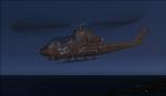
Abacus AH-1G Cobra 'Sound of Silence' C/2/20 ARA Vietnam Textures
(Category: FS2004 > Payware)
3.04Mb (81 downloads)
Textures only for the payware Abacus Premier Collection AH-1G Cobra gunship. 'Sound of Silence" was an AH-1G Cobra that flew with C/2/20 ARA in Vietnam. The unit was famously known as Blue Max and featured the Pour Le Merit on the doghouse. The textures are photo real having come directly from high resolution scans.
Hope you enjoy them. Lloyd 'Snake36Bravo' Goldston
Posted Dec 25, 2013 10:51 by Lloyd "Snake36Bravo" Goldston