


All Files > Page 1438
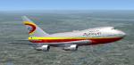
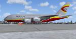
Platinum Airways Boeing 747SP FSX
(Category: FSX > Civil Jets)
10.30Mb (2304 downloads)
Full model of the Boeing 747-SP in Platinum Airway's new
fleet, for FSX only. Platinum is an open-skies virtual airline for FSX, FS9,
and X-Plane. Visit us today at platinumairways.org. Model by POSKY, paint by Alwyn Neil, installer by Vic Ayers. No VC
Posted Jul 26, 2013 21:52 by Harrison B
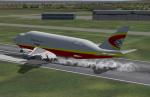
Platinum Airways Boeing 747-400LCF Dreamlifter FSX
(Category: FSX > Civil Jets)
9.34Mb (3087 downloads)
Full model of the Boeing 747-400LCF in Platinum Airway's
new fleet, for FSX only. Platinum is an open-skies virtual airline for FSX,
FS9, and X-Plane. Visit us today at platinumairways.org. Model by POSKY, paint by Alwyn Neil, installer by Vic Ayers. No VC.
Posted Jul 26, 2013 21:49 by Harrison B
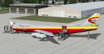
Platinum Airways Boeing 747-800F FSX
(Category: FSX > Civil Jets)
20.51Mb (1422 downloads)
Package includes: Full model of the Boeing 747-8F in Platinum Airway's new
fleet, for FSX only. Platinum is an open-skies virtual airline for FSX, FS9,
and X-Plane. Visit us today at platinumairways.org. Model by POSKY, paint by Alwyn Neil, installer by Vic Ayers. No VC
Posted Jul 26, 2013 21:46 by Harrison B
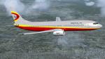
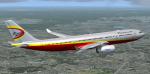
Platinum Airways Boeing 737-800 FSX
(Category: FSX > Civil Jets)
16.76Mb (1376 downloads)
Full model of the Boeing 737-800 in Platinum Airway's new
fleet, for FSX only. Platinum is an open-skies virtual airline for FSX, FS9,
and X-Plane. Visit us today at platinumairways.org. Model by POSKY, paint by Alwyn Neil, installer by Vic Ayers. No VC.
Posted Jul 26, 2013 21:42 by Harrison B
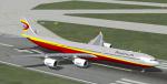
Platinum Airways Airbus A380-800 FSX
(Category: FSX > Civil Jets)
32.16Mb (6300 downloads)
Full model of the Airbus A380-800 in Platinum Airway's new fleet, for FSX only. Platinum is an open-skies virtual airline for FSX, FS9, and X-Plane. Visit us today at platinumairways.org. Model by Project Airbus, paint by Alwyn Neil, installer by Vic Ayers.
Posted Jul 26, 2013 21:40 by Harrison B
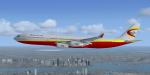
Platinum Airways Airbus A340-600 FSX
(Category: FSX > Civil Jets)
30.70Mb (6212 downloads)
Full model of the Airbus A340-600 in Platinum Airway's new
fleet, for FSX only. Platinum is an open-skies virtual airline for FSX, FS9,
and X-Plane. Visit us today at platinumairways.org. Model by Thomas Ruth, paint by Alwyn Neil, installer by Vic Ayers. No VC.
Posted Jul 26, 2013 21:36 by Harrison B
Platinum Airways Airbus A340-300 FSX
(Category: FSX > Civil Jets)
49.31Mb (2101 downloads)
Full model of the Airbus A340-300 in Platinum Airway's new
fleet, for FSX only. Platinum is an open-skies virtual airline for FSX, FS9,
and X-Plane. Visit us today at platinumairways.org. Model by Thomas Ruth, paint by Alwyn Neil, installer by Vic Ayers. No VC.
Posted Jul 26, 2013 21:33 by Harrison B
Platinum Airways Airbus A330-200 FSX
(Category: FSX > Civil Jets)
25.08Mb (2695 downloads)
Full model of the Airbus A330-200 in Platinum Airway's new fleet, for FSX only. Platinum is an open-skies virtual airline for FSX, FS9, and X-Plane. Visit us today at platinumairways.org. Model by Project Airbus, paint by Alwyn Neil, installer by Vic Ayers. No VC.
Posted Jul 26, 2013 21:28 by Harrison B
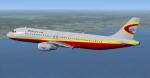
Platinum Airways Airbus A320-200 FSX
(Category: FSX > Civil Jets)
14.65Mb (1211 downloads)
Full model of the Airbus A320-200 in Platinum Airway's new fleet, for FSX only. Platinum is an open-skies virtual airline for FSX, FS9, and X-Plane. Visit us today at platinumairways.org. Model by Project Airbus, paint by Alwyn Neil, installer by Vic Ayers. No VC.
Posted Jul 26, 2013 21:24 by Harrison B
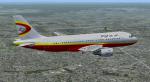
Platinum Airways Airbus A319-100 FSX
(Category: FSX > Civil Jets)
15.23Mb (1173 downloads)
Full model of the Airbus A319-100 in Platinum Airway's new fleet, for FSX only. Platinum is an open-skies virtual airline for FSX, FS9, and X-Plane. Visit us today at platinumairways.org. Model by Project Airbus, paint by Alwyn Neil, installer by Vic Ayers.
Posted Jul 26, 2013 21:18 by Harrison B