


All Files > Page 1609
Gaza Yasser Arafat International Airport, Palestine, Lights Upgrade
(Category: FSX > Scenery)
0.00Mb (386 downloads)
Gaza Yasser Arafat International Airport Lights Upgrade LVGZ, Palestine. This is a very simple upgrade that adds PAPI4 visual guide slopes to both runways and ALSF1 approach lights.
Posted Oct 2, 2012 20:52 by L.M.
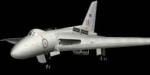
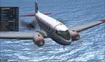
Avro 698 VX770 (Beta model)
(Category: FSX > Military)
11.81Mb (762 downloads)
Avro 698 prototype VX770 model only, with default 737-800 panel and sound. Fully working animation and better modeling to represent the original which was quite unique (shorter, different wings, different airbrakes etc). This is a big improvement on my earlier version. Enjoy. Doug Sleigh
Posted Oct 2, 2012 11:47 by Doug Sleigh
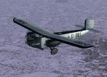
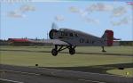
Rohrbach Roland
(Category: FSX > Vintage)
12.29Mb (1883 downloads)
Ralf Kreibich's great Rohrbach Roland now for FSX Acceleration. ALL credits are for him!! The aircraft has full VC, I also put in a minipanel, but there's NO mainpanel. 2 Different textures, Lufthansa and Iberia. All necessary gauges included. Enjoy!
Posted Oct 2, 2012 07:58 by erik hertzberger
Extra Junkers W-34 Wheels Textures
(Category: FSX > Vintage)
11.28Mb (698 downloads)
Extra textures for Ralf Kreibich's great Junkers W-34 wheels planes (as updated by me for FSX-Acceleration). Guinea Airlines, Canadian Pacific Airlines, Lufthansa and Swedish Air Force. Thumbnails included. Enjoy!
Required files:
required file
Posted Oct 2, 2012 07:53 by erik hertzberger
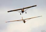
FSX RCAC 2 Aircraft Pack
(Category: FSX > Props)
12.55Mb (2415 downloads)
Royal Canadian Air Cadet Package consisting of Wolfgang Piper's Schweizer SGS 2-33A and the LIC (Long Island Classics) Bellanca Scout, repainted by Taylor Giannelia
Posted Oct 1, 2012 20:14 by Taylor Giannelia
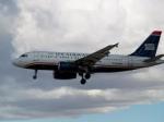
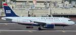
US Airways A319 Twin Package
(Category: FSX > Civil Jets)
44.75Mb (6925 downloads)
An Airbus A319 in the current US Airways livery with both IAE and CFM models. Has the default A321 VC and panel, with a custom sound set.
Posted Oct 1, 2012 18:35 by Russell Irwin
FS2004/FSX RealEngine v1.4 Aircraft Limitations
(Category: FSX > Utilities)
1.83Mb (2513 downloads)
RealEngine v1.4 fails systems and engines of piston aircraft if operating limitations are exceeded. Limitations modeled: MP / RPM / power, CHT, Oil Temp, Oil Press, Lean/Rich roughness, Spark Plug Fouling, Gear/Flaps Overspeed. Added vs v1.1/1.2: Easier configuration, realistic CHT Model, Mini Status Panel. Can be fully configured for individual aircraft. By Gunter Teson1.
Posted Oct 1, 2012 16:06 by Gunter teson1

Royal Jordanian Airlines A320
(Category: FSX > Civil Jets)
41.26Mb (3963 downloads)
Project Airbus A320 in Royal Jordanian Airline livery plus VC.
Painted by Stephen Browning
Posted Oct 1, 2012 16:05 by Stephen Browning
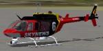

Bell 206L Longranger SkyNews 6 Textures
(Category: FSX > Helicopters)
3.42Mb (1245 downloads)
The 206L Sky News 6 is a real world helicopter from Northeastern Oklahoma. This is a repaint for the Bell 206L Longranger by: Alan Devins
Required files:
required file
Posted Oct 1, 2012 11:35 by Jerry Green
Flight Simulator X Service Pack 2
(Category: FSX > Misc)
164.53Mb (44473 downloads)
Flight Simulator X Service Pack 2.
Microsoft no longer hosts this update and many users will continue to need it into the future so Simviation is now hosting the file.
English
FSX Service Pack 2 addresses these post-release customer concerns (see the Readme file for details):
Multiplayer compatibility with FSX: Acceleration
DirectX 10 preview
IMPORTANT: If you have already installed Flight Simulator X: Acceleration expansion pack, do not install Service Pack 2.
IMPORTANT: You must install Service Pack 1 before installing Service Pack 2.
Notes:
Service Pack 2 does not include the code updates required to use the new Flight Simulator X: Acceleration aircraft. You must purchase and install Flight Simulator X: Acceleration to use those aircraft.
After you have installed Service Pack 2, you will be able to play multiplayer games only with users who have installed either Service Pack 2 or Flight SimulatorX: Acceleration.
Flight Simulator X Service Pack 1 addresses these post-release customer concerns:
Activation and installation
Third-party add-on issues
Performance enhancements
Content issues
IMPORTANT: If you have already installed the Flight Simulator X: Acceleration expansion pack, do not install Service Pack 1. NOT REQUIRED IF YOU HAVE FSX ACCELERATION OR ACCELERATION EXPANSION PACK!
Posted Sep 30, 2012 19:22 by admin