


All Files > Page 1628
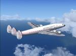
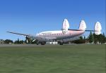
Standard Airways Constellation Textures
(Category: FSX > Vintage)
3.79Mb (437 downloads)
FSX Standard Airways textures for L-1049G Super Constellation by Manfred Jahn.
Requires L1049G.zip and L1049G_U.zip for aircraft.
Textures by Gary Harper.
Required files:
required file
Posted Sep 4, 2012 04:19 by Gary Harper
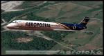
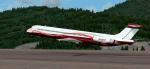
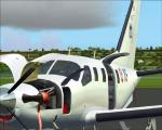
Flight 1 Super 80 Pro Aeropostal Textures
(Category: FSX > Payware)
5.19Mb (642 downloads)
Textures for the paywareSuper 80 Pro from Flight 1 and Coolsky, Aeropostal (El Varguense) Reg. YV444T Flight Simulator X
Posted Sep 4, 2012 04:19 by Trino Rojas
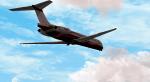
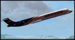
Flight 1 Super 80 Pro N168CF Textures
(Category: FSX > Payware)
5.03Mb (127 downloads)
High definition textures for the payware Flight 1 and Coolsky Super 80 Pro Reg N168CF, for Flight Simulator X
Posted Sep 4, 2012 04:12 by Trino Rojas
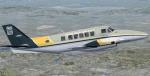
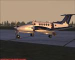
FSX Beech 99 /C99 Wagair Textures
(Category: FSX > Props)
1.07Mb (750 downloads)
FSX repaint only for Premier Aircraft Design Beechcraft 99 (C99). Wagair (Waglisla Airlines). Repaint for FSX by Enrique Medal.
File needed for FSX: beech99_4_x.zip
(I guess this repaints can be used in the FS9 version of this aircraft)
Required files:
required file
Posted Sep 4, 2012 03:41 by Enrique Medal
FSX ASTER_imp GDEMv2 30m mesh for Kiribati & Johnston atoll
(Category: FSX > Terrain Mesh)
1.29Mb (557 downloads)
"imp" means imperfect, as other mesh I have already processed is of areas that have very little vegetation cover - over the land, or has large urban areas.
This "imp" mesh will include some slight discrepancies of altitude (in the case of forested areas - by a magnitude sometimes of +15 metres-depending on how tall the trees are, in the jungle or forest canopy) over urban areas, or areas with a lot of vegetation cover - due to the limitations of the ASTER satellites infra red scanning cameras, and the software used to process the DEM data.
Areas where there is little vegetation cover, or non urban areas, the terrain should have truer values.
But I feel this ASTER DEM data is so good - why let it all go to waste - especially flying over lovely Pacific islands?
So you FSX users out there will have to take all this into account when using this mesh.
Grateful thanks to ERSDAC, and NASA for making this data freely available to the public.
ASTER GDEM
Copyright (c) 2009 - 2011 Earth Remote Sensing Data Analysis Center (ERSDAC) All rights reserved.
ASTER GDEM is a product of METI and NASA.
Posted Sep 4, 2012 03:33 by Wayne Evans
Spike's FS2004 Australia Taxiway Fixes 2
(Category: FS2004 > Scenery)
0.20Mb (532 downloads)
Spike's FS2004 Australia Taxiway Fixes Vol.2. Adds more taxiway fixes to another 97 airfields and some tweaks to airports in pack 1. This is best used with "Spike’s FS2004 Australia Taxiway fixes 1".
These airports have not been modified from their stock layout, only the taxiways have been fixed. Includes international and major airports in Australia
Posted Sep 4, 2012 01:23 by Spike
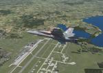
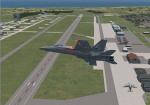
Misawa Air Base, Japan
(Category: FSX > Scenery)
6.86Mb (1976 downloads)
Watch the air base transform into full property coverage that includes more life-like flightline and taxiways, new models for true-to-life hangers, terminals, and key buildings, including the Main Gate, Exchange buildings, 9 story apartment buildings, and key elements at the Security Hill Antenna farm. See the gigantic FLR-9 (Elephant Cage) antenna and Echeleon radomes. The taxiways, polys, and roadways were corrected and updated via background image tracing in the ADE tool. The area of the Air base tripled in size. See also attached civil installations of the Misawa Airport and the Misawa Aeronautical Museum on the east end of the runway.Also take note of the Misawa AMC Terminal and added forest polygons. The scenery looks best under the summer season. This is my first release of the air base.
Posted Sep 3, 2012 14:11 by Sam Sanders
FSX ASTER_imp GDEMv2 30m mesh for Marshall Islands
(Category: FSX > Terrain Mesh)
0.88Mb (596 downloads)
"imp" means imperfect, as other mesh I have already processed is of areas that have very little vegetation cover - over the land, or has large urban areas.
This "imp" mesh will include some slight discrepancies of altitude (in the case of forested areas - by a magnitude sometimes of +15 metres-depending on how tall the trees are, in the jungle or forest canopy) over urban areas, or areas with a lot of vegetation cover - due to the limitations of the ASTER satellites infra red scanning cameras, and the software used to process the DEM data.
Areas where there is little vegetation cover, or non urban areas, the terrain should have truer values.
But I feel this ASTER DEM data is so good - why let it all go to waste - especially flying over lovely Pacific islands?
So you FSX users out there will have to take all this into account when using this mesh.
Grateful thanks to ERSDAC, and NASA for making this data freely available to the public.
ASTER GDEM
Copyright (c) 2009 - 2011 Earth Remote Sensing Data Analysis Center (ERSDAC) All rights reserved.
ASTER GDEM is a product of METI and NASA.
Posted Sep 3, 2012 12:21 by Wayne Evans
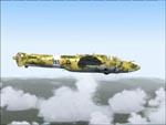
C.R.D.A. Cant Z1014 & Z512 Fix
(Category: FS2004 > Vintage)
0.13Mb (487 downloads)
FS2004- C.R.D.A.Cant Z1014 Bomber & Z512 Float Plane
Fix. For use with giuz1014_z512.zip
Includes missing wheel textures.
Sorry for the inconvenience
Required files:
required file
Posted Sep 3, 2012 04:56 by FRANCESCO GIULI
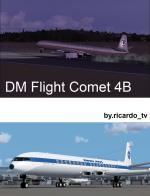

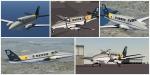
DH Comet 4 Multi Livery Package Updated for FSX
(Category: FSX > Civil Jets)
44.54Mb (13204 downloads)
Special update from DM flight simulations DH Commet package to work in FSX. New lights, smoke effects, engine configurations, views, and HD textures.
De Havilland Comet 4B was the first passenger jet to operate. accident. Pan Am had planned to buy the Comet 3 & 4 but the crash drove them to the 707. So here is the Clipper of the seas with more liveries of major airlines at that time plus some others
Air France, American Airlines, BEA, British Airways, BOAC, East African, KLM, Lufthansa, Olympic Airways, PAN AM and Bare Metal(paintkit).
The comet 4B can fly with max 81 passenger, 2.800 nmi at FL420 at a cursing speed of M.79. Please read the IMPORTANT readme file for help or question.
Textures and update by ricardo_tv. Model, VC and Livery's by DM Flight Sim.
Enjoy
Posted Sep 2, 2012 21:18 by ricardo_tv