


All Files > Page 1632
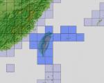
FSX Bahrain Airfield Locator
(Category: FS Navigation > Flight Simulator Navigation)
2.61Mb (102 downloads)
Tested on Windows XP and Windows 7.
This download adds airfield markers and ICAO id's found in FSX, and overlays them on Google Earth.
This file is for Bahrain.
There is also a seperate file with a list of basic airfield location details.
i.e: EGBB Birmingham Airport. Birmingham. N52* 27.23' W1* 44.88' alt325.
Also the tidying "My places" in Google Earth, file.
Other locator files to follow.
by Carl Vokes
Posted Aug 27, 2012 11:26 by carl vokes
FSX ASTER_imp GDEMv2 30m mesh for Taiwan
(Category: FSX > Terrain Mesh)
18.33Mb (1068 downloads)
"imp" means imperfect, as other mesh I have already processed is of areas that have very little vegetation cover - over the land, or has large urban areas.
This "imp" mesh will include some slight discrepancies of altitude (in the case of forested areas - by a magnitude sometimes of +15 metres-depending on how tall the trees are, in the jungle or forest canopy) over urban areas, or areas with a lot of vegetation cover - due to the limitations of the ASTER satellites infra red scanning cameras, and the software used to process the DEM data.
Areas where there is little vegetation cover, or non urban areas, the terrain should have truer values.
But I feel this ASTER DEM data is so good - why let it all go to waste - especially flying over lovely Pacific islands?
So you FSX users out there will have to take all this into account when using this mesh.
Grateful thanks to ERSDAC, and NASA for making this data freely available to the public.
ASTER GDEM
Copyright (c) 2009 - 2011 Earth Remote Sensing Data Analysis Center (ERSDAC) All rights reserved.
ASTER GDEM is a product of METI and NASA.
Posted Aug 27, 2012 08:46 by Wayne Evans
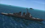
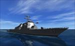
FSX DDG-51 Arlegh Burke Guided Missile Destroyers
(Category: FSX > Misc)
5.07Mb (7949 downloads)
4 FSX native AI DDG-51 'flight1' guided missile destroyers, for use with AICarriers2 utility , or other AI traffic compilers. USS John Paul Jones, USS Stethem, USS Decatur and USS Higgins.All with landable helidecks.
Posted Aug 27, 2012 06:15 by Lazarus Starkweather

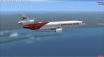
FSX Dana Air McDonnell Douglas DC-10-40D Textures V2
(Category: FSX > Civil Jets)
10.98Mb (2198 downloads)
FSX Dana Air McDonnell Douglas DC-10-40D Version 2 updated, registration number 5N-SRS, repaint for the Thomas Ruth + Eric Cantu McDonnell Douglas DC-10 PackageV2. Textures only. Requires Thomas Ruth + Eric Cantu McDonnell Douglas DC-10 PackageV2.
Required files:
required file
Posted Aug 26, 2012 20:22 by T.Marson
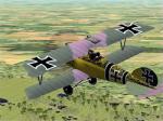
Albatros D V Sachsenberg
(Category: CFS2 > Aircraft)
1.21Mb (456 downloads)
Repaint- Albatros DV Sachsenberg Skin for Aerocrate's Albatros DV
By John Fortin (AKA Polar_Lion)
The repaint is of Gotthard Sachsenberg Albatros D V of mid 1917.
Original Aircraft: Gary Aumaugher and Model by David Eckert
This download requires the Aerocrate's Albatros D.V aircraft available here:
http://www.aerocrate.com/documents/Alb_DV.zip
Posted Aug 26, 2012 14:33 by John P Fortin
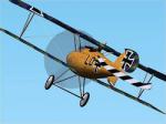
Albatros D V Osterkamp
(Category: CFS2 > Aircraft)
1.16Mb (595 downloads)
Repaint- Albatros DV Osterkamp Skin for Aerocrate's Albatros DV
By John Fortin(AKA Polar_Lion)
The repaint is of Theo Osterkamps Albatros D V of 1917. As there are no pictures, this is a fictional texture based on two descriptions of his aircraft.
"Albatros D.V from July 1917 had mauve /green wings and horizontal stab. The fuselage natural wood stippled with mauve/green. Two black fuselage bands with thin white edges. Yellow spinner and forward cowling. Black(?) wheel centres and the serial number D.2130/17 with a small 24 above serial number."
"Theo Osterkamp painted a Maltese cross and two black strips on his D.V D.2130/17 which then looked like a wasp."
Original Aircraft: Gary Aumaugher and Model by David Eckert
This download requires the Aerocrate's Albatros D.V aircraft available here:
http://www.aerocrate.com/documents/Alb_DV.zip
Posted Aug 26, 2012 14:29 by John P Fortin
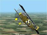
Albatros D V Udet
(Category: CFS2 > Aircraft)
1.26Mb (691 downloads)
Repaint- Albatros DV Udet Skin for Aerocrate's Albatros DV
By John Fortin(AKA Polar_Lion)
The repaint is of Ernst Udet's Albatros D V of his Jasta 37 bird in September of 1917. This maybe the plane in which he had his duel with Georges Guynemer.
Original Aircraft: Gary Aumaugher and Model by David Eckert
This download requires the Aerocrate's Albatros D.V aircraft available here:
http://www.aerocrate.com/documents/Alb_DV.zip
Posted Aug 26, 2012 14:17 by John P Fortin
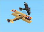
WWIDOA1917-GvO
(Category: CFS2 > Missions & Campaigns)
0.04Mb (537 downloads)
Mission - World War I Duel of Aces 1917 - Guynemer vs Osterkamp.
By John P Fortin (aka Polar_Lion)
Its about the day Guynemer spared Osterkamp's life. Georges Guynemer was already a french ace with almost 50 confirmed kills. Osterkamp had only recently become and ace. Guynemer isn't credited with this victory due to the lack of witnesses.
Even though Guynemer was alone during the duel, for the stories sake, you will be flying wing for Guynemer. You will be flying a SPAD S7 out of Bergues Bierne, just south of Dunkirk. The fight will take place over Roulers.
Posted Aug 26, 2012 14:02 by John P Fortin
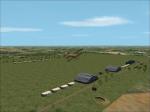
WWI1917Aerodromes
(Category: CFS2 > Scenery)
5.99Mb (759 downloads)
CFS2 WWI 1917 Airbases and GSL Scenery-
By John P. Fortin (aka Polar_Lion)
Here are eight new airbases for WWI. There are three near the Ypres area of Flanders. Two south of Verdun. One in the Somme area. Finally the last two are west of Flanders in the sub-prefecture of Pas-de-Calais. In all there are four ally and four german. You will need all of the Aerocrate scenery and aircraft which you can get from here.
Scenery:
http://aerocrate.com/addon.html
Aircraft:
http://aerocrate.com/aircraft.html
Posted Aug 26, 2012 13:55 by John P Fortin
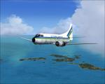

Air Florida Commuter Martin 404 textures
(Category: FS2004 > Vintage)
2.44Mb (409 downloads)
FS9/FSX Air Florida Commuter textures for Martin 404 by Dee Waldron
Requires the model by Dee Waldron. Textures by Gary Harper.
Required files:
required file
Posted Aug 26, 2012 00:52 by Gary Harper